Cruising Guide to the Philippines
For Yachtsmen
By Conant M. Webb
Draft of 06/16/09
Webb - Cruising Guide to the Phillippines
Page 2
INTRODUCTION
The Philippines is the second largest archipelago in the world after Indonesia, with around 7,000
islands. Relatively few yachts cruise here, but there seem to be more every year. In most areas it
is still rare to run across another yacht. There are pristine coral reefs, turquoise bays and snug
anchorages, as well as more metropolitan delights. The Filipino people are very friendly and
sometimes embarrassingly hospitable. Their culture is a unique mixture of indigenous, Spanish,
Asian and American. Philippine charts are inexpensive and reasonably good. English is widely
(although not universally) spoken. The cost of living is very reasonable.
This book is intended to meet the particular needs of the cruising yachtsman with a boat in the
10-20 meter range. It supplements (but is not intended to replace) conventional navigational
materials, a discussion of which can be found below on page 16.
I have tried to make this book accurate, but responsibility for the safety of your vessel and its
crew must remain yours alone.
CONVENTIONS IN THIS BOOK
Coordinates are given for various features to help you find them on a chart, not for uncritical use
with GPS. In most cases the position is approximate, and is only given to the nearest whole
minute. Where coordinates are expressed more exactly, in decimal minutes or minutes and
seconds, the relevant chart is mentioned or WGS 84 is the datum used. See the References
section (page 157) for specific details of the chart edition used. Be very wary of applying
coordinates from one chart to another, as charted features may not be at the same coordinates on
different charts. If possible, positions are usually best transferred by range and bearing from a
well-defined landmark.
Bearings are true and, where precision is intended, are expressed in degrees from 000° (North) to
359°, measured clockwise. Less exact bearings are expressed by the names or initials of points of
the compass.
Depths, heights and distances are given in nautical miles (nm), feet (ft), meters (m), or fathoms
(fm), generally intending to be consistent with the current Philippine chart of the area. A
conversion chart appears in Appendix A (page 141).
Buoys, lights and other aids to navigation in the Philippines are not as reliably maintained as
those in wealthier nations. Never assume that they will be as charted.
Geographical points appear in the Gazetteer (page 127). The Index (page 140) contains references
to other subjects.
A RANT ABOUT GPS, ELECTRONIC CHARTS AND THE LIKE
Modern navigation tools can create dangerous overconfidence, especially in the inexperienced
and unwary. The devices can and do fail, usually at a very inconvenient time. Expect it. Even
more dangerous is failing to understand the limitations of your navigation. GPS may give you
an incredibly accurate fix, but that's only half of the problem. There can be uncertainties in the
location of charted features, either in relation to the datum set on your GPS or because of older
charting methods. Some modern charts of the Philippines are based on surveys as old as the 19th
century, and most are based on pre-GPS surveys. A few areas remain unsurveyed.
Most Philippine charts do not indicate the datum used and correction factors for use with GPS
are only given on some of the most recent new editions. Given the possibility of divergence
between GPS positions and charted positions because of datum shift, and the age of some of the
Draft of 16 June, 2009 16:14
Filcru16.doc
Revision 9
© 2002-09 Conant M. Webb. All rights reserved.
Please send comments and corrections to [email protected].
Webb - Cruising Guide to the Phillippines
Page 3
surveys, it is at least as foolish to rely solely on GPS in the Philippines as anywhere else in the
world. If you don't understand what a datum is, this is particularly true.
It is essential to navigate using several independent means of fixing your position as much as
practicable. Keep a reasonable dead reckoning plot, and don't get careless. Keeping ahead of
the boat and taking reasonable precautions while still able to have been the basis of good
seamanship for thousands of years and fundamentally nothing has changed. No matter what the
salesmen would like you to think, having a chandler's dream inventory on board (preferably
orange, electronic or both) doesn't make you safe. If it creates overconfidence, it has the opposite
effect.
AUTHOR'S NOTE
This is very much a work in progress. Only some portions are complete. There are undoubtedly
errors and things missed in the rest. Things change, or I got it wrong in the first place. My
apologies in advance. Be careful about trusting any single source of information, including this.
I would be very grateful for any corrections or comments. It can take a little time to catch up
with me, but any of the following will eventually get there: in care of the Puerto Galera Yacht
Club, (Puerto Galera Yacht Club, Sto. Niño, Puerto Galera, Oriental Mindoro, PO Box 30450), or
via Email at co_webb@hotmail.com
Please email me if the date on this draft seems old – I intend to keep updating it, and if you are
willing to give me comments, I am willing to give you a new draft at the cost of reproduction.
One cruiser I asked for help violently objected. He seemed to think it was immoral to 'exploit'
the Filipinos by disseminating this sort of information, and that it would inevitably lead to the
debauchery of its people, overdevelopment, and destruction. Aside from it being fairly obvious
that Filipinos are perfectly capable of debauchery, overdevelopment and destruction without
assistance, I doubt this modest effort will have much effect on the number of yachts visiting the
Philippines. It will be many, many years before the Philippines has the sort of crowded sailing
like Phuket, the Caribbean or the Med.
Like most sailing directions, this is full of warnings and descriptions of hazards. My first priority
has been to help you avoid trouble, so there has been a tendency to focus on the negative. The
good points of the Philippines will be obvious to the yachtsman at his first visit. A surprising
number wind up staying more or less permanently.
Draft of 16 June, 2009 16:14
Filcru16.doc
Revision 9
© 2002-09 Conant M. Webb. All rights reserved.
Please send comments and corrections to [email protected].
Webb - Cruising Guide to the Phillippines
Page 4
ACKNOWLEDGMENTS
The Philippines are too large for any individual to write a complete cruising guide exclusively
from his own experience.
Leslie Pickard and other members of the Manila Yacht Club prepared a photocopied cruising
guide to the Philippines in 1986-7 covering W Luzon as far North as San Fernando, the
Calamains and NW Palawan, Mindoro and parts of the Sibuyan Sea. It includes photocopied
sections of the charts for the anchorages described. It was a valuable pioneering work, and a
useful reference in beginning this effort.
Most important have been interviews with fellow yachties who let me pick their brains:
Name Boat(s)
Gordon Chica Amo
Shane Scott Akila, Blidö
Carl Broquvist Chom II
Olaf Tomforde
Fitz & Trish Columbus
Mary & Terry Iverson Valkyrie
Mike Bjornback Taranui II
Mike Tucker Tayana Lady
Russ Hughes Karis
R. John Skinner Naiche
Dan Green Kalia, Mahi Mahi
Many thanks for their willingness to be interrogated about their movements, sometimes at
length. Thanks also to those who preferred not to be identified. While the aforementioned must
share in the credit for accurate information, the blame for errors must remain the Author's.
Thanks also to Beth of the Harbor Point Bistro on Muelle Pier, Puerto Galera for allowing me to
camp out for days at a time writing. Thanks also to Sven.
Draft of 16 June, 2009 16:14
Filcru16.doc
Revision 9
© 2002-09 Conant M. Webb. All rights reserved.
Please send comments and corrections to [email protected].
Webb - Cruising Guide to the Phillippines
Page 5
CONTENTS
Draft of 16 June, 2009 16:14
Filcru16.doc
Introduction 2
Conventions in this Book 2
A Rant 2
Author’s Note 3
Acknowledgements 4
Cruising High Points 8
Certain Considerations About the Philippines 8
The People of the Philippines 10
History 10
The Current Situation 11
Language 11
Filipino English 13
Gestures 13
Cultural Issues 14
Cruising Considerations 15
The Boat and Her Gear 15
Navigation Publications 16
Weather 19
Typhoons 20
Definitions 20
Structure 21
Development and Movement 23
Frequency 24
Signs of an Approaching Typhoon 24
Tactics 25
Typhoon Refuges 28
Weather Forecasts 29
El Ninõ and la Nina 31
Tides and Currents 31
Coral Waters 32
Biology 32
Navigation In Coral 33
Fishing Methods 35
Passages To and From the Philippines 35
Regulations 37
Ports of Entry 37
Immigration and Visas 39
Corruption 39
Crime 39
Hustles 39
Insurgencies 40
Piracy 44
Health 45
Medical Kit 45
Hazardous Marine Life 45
Emergencies 47
Self Reliance 48
SAR 48
Mayday Procedures 48
Hyperbaric Chambers 48
Overhaul and Repair Facilities 48
Yacht Charter 49
The Regions 50
Northwest Region 51
Manila Bay 51
Marivales to Lingayen Gulf 52
Lingayen Gulf to Cape Bojeador 58
Northeast Region 63
Luzon North Coast 63
Luzon Strait 64
Luzon East Coast 65
West Central -Southwest Luzon; Mindoro; Sibuyan Sea; N
and W Panay, Burias, Ticao and Masbate;
69
Luzon - Manila To Cape Santiago 69
Verde Island Passage Area
East Central Region 88
Revision 9
© 2002-09 Conant M. Webb. All rights reserved.
Please send comments and corrections to [email protected].

Webb - Cruising Guide to the Phillippines
Page 6
Draft of 16 June, 2009 16:14
Filcru16.doc
Southeast Region - Mindanao and the Sulu Archipelago 105
Southwest Region
Palawan, Calamian Group, Balabac Strait, Dangerous Ground
and Islands of the Sulu Sea
111
Revision 9
© 2002-09 Conant M. Webb. All rights reserved.
Please send comments and corrections to [email protected].
Webb - Cruising Guide to the Phillippines
Page 7
CHARTLETS
Draft of 16 June, 2009 16:14
Filcru16.doc
Geographical Distribution of Major Languages 11
How to find the NIMRA chart sales office in Manila [to Come]
Typhoon Refuges 28
Routes to and From the Philippines 35
Regions 50
Northwestern Region 51
Northeastern Region 63
West Central Region 69
Mactan Wreck 78 [To Come]
East Central Region
Southeastern Region
Southwestern Region 111
Location of the Philippines
Port Carmen, Cebu
Puerto Galera, Mindoro 73
Boracay I 81
TABLES
Comparative Languages 12
Saffir/Simpson Hurricane Scale 23
Frequency of Typhoons Crossing the Philippines 24
Latitudes of Typhoon Formation 24
Diurnal Barometer Corrections 24
Typhoon Refuges 28
Gazetteer 127
APPENDICES
A - Distance Conversion 141
B - Seconds to Decimal Degrees 143
C - Northwest Pacific Typhoon Names 144
D - JMH Radiofax Schedule 145
E - BMF Radiofax Schedule 148
F - AXI Radiofax Schedule 150
G - Internet Links 151
Revision 9
© 2002-09 Conant M. Webb. All rights reserved.
Please send comments and corrections to [email protected].
Webb - Cruising Guide to the Phillippines
Page 8
CRUISING HIGH POINTS
Many parts of the Philippines rarely see a cruising yacht. Exploring can be very rewarding. The
most popular cruising areas are probably the Culion group and the northern end of Palawan,
and the area from Manila and Subic down to the Sibuyan and Visayan seas. There is a fair
amount of yacht traffic back and forth from Hong Kong, and some yachts travelling East to West
via the Surigao and San Bernadino Straits.
The northern end of Palawan, especially around El Nido and the adjacent islands of Culion,
Coron and Busuanga consistently get very high praise from cruisers. The Southern end of
Surigao has much of the same sort of limestone towers, natural arches and pure white beaches as
the Palawan area, but is smaller and less popular.
[Still need to think about this -- Suggestions needed!]
CERTAIN CONSIDERATIONS ABOUT THE PHILIPPINES
There are a few things that always come up in general discussion about cruising in the
Philippines.
Typhoons
Typhoons do not have to be a terrible worry if you pay attention and take timely action. As in
many areas of the world, you will occasionally have to spend some time in a sheltered anchorage
waiting for the weather to moderate or waiting to see which direction a developing storm will
take. In all seasons it is essential to keep an eye on the weather and know what your plan will be
if a typhoon threatens. Good preparation and timely action are your best defenses. See page 20
for a more detailed discussion.
Fish Aggregating Devices (FADS)
FADs (Payao in Tagalog, gacket in Visayan, balsas in Ilonggo) are buoys put in deep water to
attract valuable pelagic species of fish, especially tuna. In Philippine waters these range from
low bamboo rafts fairly close inshore to steel rafts or cylinders as large as 3-4 m in diameter and
5-10 m long. The largest ones may be anchored in water up to 5,000 m deep, and can be 60 miles
or more offshore. They are not lit at night, and have no radar reflector, although some have a
palm frond. Other than good watch keeping, there's not too much that can be done about this
problem. It's the single greatest risk of cruising in the Philippines.
Fishing Bangkas
The local double outrigger boats are generally called 'bangkas', regardless of whether they are
propelled by paddle, sail, small gasoline engine or diesel. Sizes range from barely large enough
for one person to well over 100 feet. They are generally poor radar targets. Most do not have
running lights. Some only carry a cigarette lighter a flashlight. In some areas the larger ones
have some semblance of running lights but the pattern and placement only resemble the rules of
the road requirements vaguely. For night fishing, some of the larger ones have powerful arrays
of floodlights and some of the smallet ones use pressure kerosene lamps.
They can be found well offshore, routinely asfar as 50-75 miles, usually in groups around good
fishing spots like shoals. Sometimes there is no obvious reason for their location. At night, an
unlit bangka who sees your running lights and believes you may run them down will use their
lighter or turn on their flashlight (if they have one that works). When you alter course to avoid
Draft of 16 June, 2009 16:14
Filcru16.doc
Revision 9
© 2002-09 Conant M. Webb. All rights reserved.
Please send comments and corrections to [email protected].
Webb - Cruising Guide to the Phillippines
Page 9
the ones you can see, the bangkas you are now heading for will use theirs. It can be very
frustrating.
I generally try to avoid making inshore passages in the Philippines at night when there is no
moon or in order to reduce the risk of colliding with bangkas or the bigger FADs.
See page 35 for a more detailed discussion of local fishing methods.
Crime and Politically Motivated Violence
There is crime in the Philippines like anywhere else. Given the degree of poverty in which the
majority of Filipinos live, it is remarkable how little there is. Urban areas are worse than rural
areas. By and large it's not a major problem for the cruiser. Before going to urban areas there are
a few ingenious scams it's good to be aware of, discussed on page 39.
There are several rural and urban insurgencies in the Philippines that proclaim political
motivation, some of whose actions seem at least partially driven by economics. The politically
motivated groups are generally not interested in yachts.
As a general matter the Muslim insurgencies are confined to western Mindanao and the Sulu
Archipelago, and the communist insurgents tend to be in the mountains rather than the seaside.
See [historical section to come] for a discussion of their development and page 40 about the
situation as of this writing. The situation in the Philippines can be fairly fluid, so it is sensible to
pay attention to the media. I find the Internet to very helpful tool to keep abreast of Philippine
affairs. You can also check whether your consulate has issued any warnings for the Philippines.
Disease and Health
In the Philippines, like anywhere in the world, especially developing countries, it is prudent to
take appropriate precautions against certain health risks. None are particularly onerous. The
quality and availability of medical care is highly variable, and it is sensible to be somewhat self
reliant. See page 45 for a more detailed discussion of these issues.
Draft of 16 June, 2009 16:14
Filcru16.doc
Revision 9
© 2002-09 Conant M. Webb. All rights reserved.
Please send comments and corrections to [email protected].
Webb - Cruising Guide to the Phillippines
Page 10
PEOPLE OF THE PHILIPPINES
HISTORY
Before European Contact
There are many descriptions of the Philippines by Europeans at the time they were "discovered".
The earlier history is less clear.
The land is mostly volcanic in origin, except for Palawan. Palawan was at one point connected
by land bridge to Borneo, but the rest of the Philippines were never connected with the Asian
mainland while humans were around. Humans were making significant sea crossings in and
from Southeast Asia as early as 40,000 years ago.
The earliest human remains found in the Philippines so far are part of a skull and jaw that were
buried outside Tabon Cave, Palawan. These bones are about 20,000 years old, Homo Sapiens (like
modern people), and seem to be of a woman with characteristics resembling Australian
aboriginal peoples or Philippine Negritos. Negritos live mostly in remote upland areas. They
tend to have darker skins, frizzy hair and are of relatively small stature compared to present day
lowlanders.
Austronesian speaking peoples probably began to arrive in the Philippines from Taiwan in
around 5,000 BC, bringing agriculture, metals, domesticated pigs and dogs, and a variety of other
technologies to the Philippines. There was undoubtedly also movement from the South and from
mainland Asia. The famous Ifugao rice terraces of central Luzon probably date back to about
2,000 years ago, roughly the time that the first cultivated varieties of rice appear. By the early
centuries of the Christian Epoch Austronesian speakers had spread by sea as far East as Easter
Island (Rapa Nui) and as far West as Madagascar. When Europeans arrived in the Philippines in
the 16
th
century, the Negritos were speaking Austronesian languages that were more closely
related to the nearest lowland group than to languages spoken by other Negritos elsewhere,
indicating that there had been prolonged contact and interchange between the Negritos and the
Austronesian speaking lowlanders. Older theories specified specific ‘waves’ of new arrivals to
the Philippines based on various types of artifacts supposedly associated with each wave, but
radiocarbon dating of organic matter has largely discredited these notions.
By the 9
th
century AD there was certainly fairly extensive trade between Vietnam and China and
some regions of the Philippines. Chinese and Vietnamese pottery of this period was found in
excavations in Butuan, Mindanao, along with the remains of two boats, one of which was 15
meters long, large enough to have carried out fairly extensive trading voyages. There seems to
be a clear reference to Butuan in the Chinese Sung Shih, or Sung Song, history of 1001 AD.
Most excavations after the 9
th
century in the Philippines can be dated by the styles of Chinese
pottery discovered. In many burials there are many pieces of pottery found with the body. We
can only speculate about why.
There were several indigenous forms of writing, one of which survives among the Mangyan
peoples of the highlands of Mindoro, and a similar one that survives among the Pala'wan
indigineous people of Palawan. Virtually no writing has survived from the pre-hispanic period,
and it is controversial how widespread literacy was. The ancient scripts are all similar. The
ancient Tagalog form, baybayin, had one symbol for each of 17 consonants, with diacritical marks
placed above or below each symbol to indicate the vowel associated with the consonant. This
seems to be related to Sanskrit or other ancient scripts used on the Indian subcontinent.
Draft of 16 June, 2009 16:14
Filcru16.doc
Revision 9
© 2002-09 Conant M. Webb. All rights reserved.
Please send comments and corrections to [email protected].

Webb - Cruising Guide to the Phillippines
Page 11
[More to come]
THE CURRENT SITUATION
[To come]
The Philippines are about 83% Roman Catholic, with about 9% Protestant, 5% Muslim and 3%
other.
LANGUAGE
Depending on where one draws the line
between a language and a dialect, there are as
many as 150 different languages in the
Philippines. The official languages are Engl
and Filipino. Filipino is essentially Tagalog
(pronounced tag-á-log) with some add
from other languages. Tagalog is the langu
of the Manila region and of films and television.
It has been mandatory in school since 1974, a
is fairly well understood in most places, muc
more commonly than English is. The others
have fairly strong geographic associations.
However, there have been substantial internal
migrations, including from rural areas to urba
ones and between the rest of the Philipp
Mindanao, depending on the ebb and flow of
fighting between government forces and
insurgents.
Draft of 16 June, 2009 16:14
Filcru16.doc
ish
itions
age
nd
h
n
ines and
The native languages of about 90% of Filipinos
are one of eight languages:
Tagalog - Central and Southern Luzon,
including Manila, Northern Mindoro, Lubang Is
and Marinduque I. About 14,850,000 first
language speakers (24% of the population). Tagalog is the foundation of Filipino, the 'National
Language', and is the major language of TV and movies. As such it is used to some degree by
many Filipinos (one estimate is an additional 24,000,0000) as a second language.
Cebuano - Eastern Negros, Cebu, and Bohol. About 15,230,000 speakers (24%).
Ilocano - Northwestern Luzon, La Union and Ilocos provinces, Cagayan Valley, Babuyan. ('The
right side of the Agno River', according to chauvinists') About 8,000,000 speakers (11% of the
population).
Ilonggo (Sometimes also called Hiligaynon) - Panay, Guimiras, Western Negros and some of the
surrounding islands. About 7,000,000 speakers (10%).
Bicolano - the Bicol region of Southern Luzon - from the East side of the Ragay Gulf to the San
Bernadino Strait, Southern Catanduanes, Masbate and some of the surrounding islands.
'Central' Bicolano is spoken by some 2,500,000; together with other closely related Bikol
languages about 4,000,000 or 7% of the population.
Waray - Northern and eastern Leyte and Samar. 3,000,000 or about 5% of the population.
Revision 9
© 2002-09 Conant M. Webb. All rights reserved.
Please send comments and corrections to [email protected].

Webb - Cruising Guide to the Phillippines
Page 12
Pampangeno - the Central valley of Luzon from the North part of Manila Bay to about Tarlac -
Pampangas Province, plus most of Bataan. 2,000,000 or about 2-3% of the population.
Pangasinan -Lingayan Gulf area. 2,000,000 or 2-3% of the population. Pangasinan Province,
Luzon.
The Visayan languages, Cebuano, Ilonggo and Waray, are more closely related to each other than
to the others. Ilocano and Pangasinan are likewise closer to each other than to the other six.
For a detailed breakdown counting 171 (168 living, 3 extinct) Philippine languages see
http://www.sil.org/ethnologue/countries/Phil.html. There are a variety of links to web sites
to help learn various Philippine languages in Appendix G.
Of the minority languages about ten are associated principally with the Muslim ethnic groups of
the South: Tausug, Maranao, Maguindanao, ….
[Insert English-Tagalog-Visayan sailing glossary as appendix?]
Almost all of the indigenous Philippine languages are classified as Malayo-Polynesian, related to
those spoken from Easter Island (Rapa Nui) and Hawaii through Indonesia and Malaysia to as
far West as Madagascar. This table shows the translations of some selected words in English and
six Malayo-Polynesian languages, giving some indication of the relationships:
English Tagalog Visayan Indonesian/M
alay
Fijian Hawaiian Marshallese
coconut
1
niyog lubi nyuir niu niu ni
die namatay patay mati mate make lot
eye mata mata mata mata maka maj
fish isda isda ikan ika i'a ek
five lima lima lima lima lima
lalaem
2
leaf dahon dahon daun drau lau bolok
mosquito lamok lamok nyamuk namu makika jokwajok
rain ulan ulan hujan uca ua wot
sky langit langit langit lagi lani lan
two dalawa duha dua rua lua ruo
wind hangin hangin angin lagi makani
an
3
yam ubi ubi ubi uvi uhi
iaam
4
Draft of 16 June, 2009 16:14
Filcru16.doc
1
In areas where the coconut is indigenous and important people tend to have many different
words relating to variety, stages of growth and so on. In Tagalog, for example, there are:
buko - nut ready for drinking
niyog - nut for making coconut milk
tubu - nut about to sprout, right for planting
makapuno - a small, yellow-orange variety of nut
2
But 'lima bukwi' for five hundred and 'lima dep' for five thousand.
Revision 9
© 2002-09 Conant M. Webb. All rights reserved.
Please send comments and corrections to [email protected].

Webb - Cruising Guide to the Phillippines
Page 13
There is an extensive wordlist comparison between Austonesian languages at
http://www.geocities.com/Tokyo/8908/firemount/austroframes.html. (Some classifications
use 'Austronesian' rather than 'Malayo-Polynesian'.)
[Tagalog alphabet has no letter C, and puts K in its place between B and D]
Despite 350 odd years of Spanish rule, Spanish is not an important language in the Philippines.
However, the Spanish period has had an impact on languages spoken in the Philippines. There
are many words of Spanish origin in most Philippine languages, and in most markets you will
hear spanish numbers used alongside local numbers. For a variety of reasons including the
relatively small number of Spaniards that ever were in the Philippines, the use of local languages
by the Catholic Church, and the tendency of the Spanish colonialists to return to Spain rather
than settle in the Philippines, Spanish did not survive the American introduction of education in
English during their occupation of the Philippines. In its pure form, Spanish is still spoken by a
few elite families, and a few Philippine universities required proficiency in Spanish until
relatively recently.
F
ILIPINO ENGLISH
The Philippines are promoted as the 'largest English speaking nation of Asia'. This presents a
very misleading impression. While one can get by pretty well speaking only English, only a very
small proportion of the population is fluent. Be wary of assuming that Filipinos from rural or
poor backgrounds understand you in English, even if they say they do. 'Do you understand?' is
a useless question most of the time, as the answer will be 'yes', even if the question is not
understood.
You will find that some English words used by Filipinos don't have quite the same meanings a
native English speaker would expect. [Examples... some trade names as generics e.g. colgate for
toothpaste, rayban for sunglasses... wait a while.... it's up to you.... dictionary for book, foreigner
for a person of european ancestry. A 'standby' is someone who stands by waiting for casual
employment; Someone who is a passenger on an available space basis is a 'chance passenger'. Be
careful about the tenses and genders used by Filipinos speaking English. ]
Gestures
Various gestures used in the Philippines have different meanings from what a westerner is used
to. Beckoning someone to come is done by raising the arm with the palm of the hand toward the
person and making a scooping motion downward with the hand and arm. The western style
gesture with the back of the hand toward the person is considered impolite and should be
avoided. When a Filipino raises both eyebrows it means "yes". This is particularly confusing
when the Filipino has his back to the foreigner. Filipinos point to things with their lips
sometimes. Pointing at a person with the finger is considered somewhat threatening, and
certainly impolite. A Filipino who doesn't understand something you've said will open his
mouth.
3
Marshallese uses one word, 'tomean', for 'to sail downwind with the sail on the South and the
outrigger on the North'. Marshallese canoes have single outriggers which are always kept to
windward. Like most single outrigger canoes, they are tacked by reversing direction.
4
Iaam is probably a loan word from English. The Marshalls are atolls, unsuitable for growing
yams.
Draft of 16 June, 2009 16:14
Filcru16.doc
Revision 9
© 2002-09 Conant M. Webb. All rights reserved.
Please send comments and corrections to [email protected].
Webb - Cruising Guide to the Phillippines
Page 14
CULTURAL ISSUES
This section is about culture in the sense anthropologists might use the word: the shared
attitudes Filipinos use to function within their society. Everyone does not share these attitudes,
but pretty much everyone is aware of them as norms. Of course, no individual can be relied on
to act the way this discussion suggests, but some generalizations may be useful.
For Filipinos the future is very uncertain. There is no social safety netfor the poor. In some form,
most people worry where the next meal is coming from. It may be whether they will still be
employed in some industrial or agricultural enterprise, whether the crops or fishing will be will
be good. There are typhoons, earthquakes, volcanic eruptions, floods, coups, riots, and
revolutions. Wealthier Filipinos worry about capricious government and insurgent action. In
the 20th century, the Philippines was invaded twice by the Americans and once by the Japanese,
there were four or five major counter insurgencies (two of which continue, although somewhat
reduced in scale), the Marcos period of authoritarianism and the subsequent EDSA coup. In this
century there has already been the semi-constitutional 'EDSA II' coup. In preceding centuries,
there were seaborne raiders from the South and massive changes in life and religion forced by
the Spanish. Some suggest this led to what some people call a 'culture of uncertainty': a cultural
assumption that unpredictable and dangerous things are likely to happen.
Family and other sorts of alliances are very important to most Filipinos. In addition to family,
these alliances can be centered on ethnolinguistic groups, friendship, various forms of
indebtedness (see ‘utang na loob’, below) and insurgent or criminal gangs. In politics and
business strong ties of loyalty between members of college fraternities are often very important.
It's often hard to say how important being 'Filipino' is to many Filipinos, especially in rural non-
Tagalog areas. Many will identify themselves as Ilongga, Ilokano, Cebuano, Tausog or whatever
before Filipino. Some of these social structures seem to be ways of compensating for a lack of
certainty about the future.
It is accepted in the Philippines that from baptism to death one needs godfathers for everything -- whether
to get justice, obtain a passport, or to carry on any kind of business.
- José Rizal, El Filibusterismo (1891)
Another compensating mechanism may be the cheerfulness that Filipinos are famous for.
Somehow, no matter how hard things are, Filipinos seem to be able to smile. "bahala na" is the
phrase - - something like the Vietnam grunt's 'don't mean nuthin', but not as bitter. Or
indo/Malay 'tidak ada apa' - a sense of cheerful fecklessness. What does it matter? Or, who
cares?
But there's a limit to the cheerfulness. Filipinos often have a sense of personal pride that seems
exaggerated to a Westerner, or at least to Northern European. There's both a Latin pride and
machismo and an Asian concept of 'face'. Very serious offense may be taken over what might
appear to be very minor to a Westerner. Sometimes Filipinos seem mercurial. They are not so
far from the Malays described by Joseph Conrad. Amuck is a word in most Philippine languages
as well as in Malay.
An important Filipino virtue is pakikisama - getting along together. It is undesirable culturally
to show anger or conflict. Public display of anger is dangerously close to amok. For the foreigner
in the Philippines, reacting to frustration with anger is almost never a successful approach. It
diminishes the status of the angry foreigner much more than it motivates the Filipino to do
anything other than avoid the foreigner in future.
Draft of 16 June, 2009 16:14
Filcru16.doc
Revision 9
© 2002-09 Conant M. Webb. All rights reserved.
Please send comments and corrections to [email protected].
Webb - Cruising Guide to the Phillippines
Page 15
Rumor and gossip
Witchcraft, faith healing and the like
Attitudes toward Foreigners - not uncommon for mothers to threaten their children with a
foreigner who will put them in a machine to render the grease out of their bodies. A
curious parallel with a Central American tale.
Directions and answers to questions - hiya requires that the question be answered, even if
the answer is unknown. Directions will never be detailed. Often the response will be
'doon' ('over there') and a vague wave of the hand
Palabas - showiness, hucksterisim, baffling 'em with bullshit
Hiya - literally means something like 'shame' but has a far more important role in the
culture than the Western concept. 'Walang hiya' ('without shame') is a far more
serious criticism than 'shameless hussy' would be. 'Shameless' even has a bit of an
archaic feel to it in English. Hiya has a sense of social conformity.
Companions for almost everything
Bayanihan
Utang na loob/ godfathers
Bakla
On Boatboys and Boatgirls- labor is so inexpensive that the practice for most resident boats
is to hire one or several people to look after the boat. Advances, loans, honesty,
ignorance, loyalty, support of the family
Modesty Standards
Don't flaunt wealth - but most Filipinos will assume that you're unimaginably wealthy
anyway. In the terms of the average Filipino, you probably are.
Remove shoes before entering a home.
Bula Bula]
CRUISING CONSIDERATIONS
THE BOAT AND HER GEAR
Obviously, the boat must be seaworthy enough for what you do with it. There are many good
discussions of seaworthiness in other places. I would add that offshore racing requirements are
bare minimums designed to attempt to restrain the overly competitive.
Ground tackle must be adequate, in the worst case, to ride out a typhoon. I carry three ordinary
size anchors and one extra large storm anchor. Chain is important to protect the rode against
chafe on coral or rocky bottoms, and to keep the pull on the anchor more parallel with the
bottom. Some long warps that can be run ashore or used when carrying out an anchor are very
handy. It is easy for improperly stowed warps to become horribly tangled, as they are not
needed often. The solution is frequent application of stops to a proper coil. Chafe is probably
more dangerous to a boat anchored in bad weather than the ultimate strength of the ground
tackle. It's a good idea to collect old hose, leather, stout fabric, and small stuff for serving.
Careful attention to the way your lines run is also important, as are properly designed chocks,
fair leads and bow rollers. Long rodes can be helpful at times when there is no option but to use
a deep anchorage.
The Philippines are tropical. Shade is important both at anchor and underway. Awnings to
protect the watch while underway and to cover most of the boat while at anchor make a
tremendous difference. These should be designed with an eye to collecting rainwater for
Draft of 16 June, 2009 16:14
Filcru16.doc
Revision 9
© 2002-09 Conant M. Webb. All rights reserved.
Please send comments and corrections to [email protected].
Webb - Cruising Guide to the Phillippines
Page 16
drinking. Below decks, good ventilation consistent with keeping the boat seaworthy is
important. Insect screens are necessary in calm weather in some anchorages.
Fuel and water containers are necessary, as there are few places to load fuel or water alongside.
Unfortunately the containers that are readily available in the Philippines tend to be very poorly
made. Bring some extras if you can.
In more remote parts of the Philippines there is usually only very basic medical care available. It
is sensible to be prepared to be fairly self reliant when faced with health problems. Many
modern drugs are available in the cities, but can sometimes be hard to find. It is quite common
for people in rural areas to ask yachtsmen for help with a wide range of medical problems. My
policy is to help when I am confident that I understand enough about the problem to be sure that
I am not going to cause harm. In addition to a fairly extensive medical kit, some good reference
works such as the Merck Manual and the WHO Ship Captain's Medical Guide are invaluable.
Spares, Spares and more Spares [NB outrageous duties will be charged on spares coming in from
overseas even if you're a yacht in transit] Impellers, outboard props and plugs, zincs Incidentally,
it's a poor idea to have a package to you labeled 'yacht in transit' in the Philippines. The word
'yacht' will make the customs people think that a bigger bribe can be extracted from you.
It is a good idea to have an accurate barometer on board to keep track of the pressure in your
area. It can give you one of the earliest and most reliable indications of an approaching storm. A
recording barometer (barograph) is convenient. I like weather fax, which can be done either with
a dedicated machine or a computer interfaced to a SSB radio.
Ratlines or mast steps can be helpful for visual navigation in coral.
Depth sounder
The quality of fuel available in the Philippines is highly variable. Dirt and water are frequently
present, and meticulous cleanliness and the use of good, large filters both when filling your tanks
and before the fuel comes from the tanks to the engine are crucial. Unfortunately this may not
prevent problems, so a good sump in each tank and good access hatches for tank cleaning are
desirable. If the boat size and budget allow, a day tank system can help deal with poor fuel. A
day tank is a relatively small fuel tank where fuel is stored for short term consumption. It is
filled from the main tanks, often through filters and is generally high and narrow with a good
sump for efficient settlement of sediment and water.
Liquid propane (LP) cooking gas is inexpensive and readily available. There are several
connections, including the one with a left hand tapered female thread on the bottle the same as is
used in the US, Australia and New Zealand. There may be some reluctance to refill your bottles,
but the deposit on the local ones is not prohibitive. It may make sense to be equipped to transfer
the gas to your own bottle if you require a particular size and shape bottle to fit your propane
locker.
Basic foodstuffs are readily available most everywhere in the Philippines. Some luxuries or
Western foods can be hard to find.
NAVIGATION PUBLICATIONS
There are three options for charts, pilots, light lists and tide tables for the Philippines. Philippine
(NAMRIA: National Mapping and Resource Information Authority), US (NIMA: National
Imagery and Mapping Agency), and British Admiralty (BA).
Charts
Draft of 16 June, 2009 16:14
Filcru16.doc
Revision 9
© 2002-09 Conant M. Webb. All rights reserved.
Please send comments and corrections to [email protected].

Webb - Cruising Guide to the Phillippines
Page 17
The US and Philippine chart coverage is similar, and often based on the same original surveys.
The numbering is different, as the Philippine numbers are based on the pre-independence US
Coast and Geodetic Survey numbers. US charts are generally better printed, but are more
expensive and lack some of the detailed coverage available in the Philippine portfolio. BA charts
are the most expensive, and do not have as detailed coverage as the US or Philippine charts. As
of November 1999, Philippine charts cost 250 pesos for black and white, 300 pesos for color. It
was then about 40 pesos to the US dollar.
Charts can be corrected by the appropriate nation's notices to mariners, although I have almost
never met a yachtsman who does so regularly. Philippine Notices to Mariners are published by
the NAMRIA Coast and Geodetic Survey Department, 421 Barraca Street, San Nicholas, Manila.
They are also available on the internet at http://www.namria.gov.ph under the heading
'publications'.
Tide Publications
The most convenient tide publication for the Philippines, by far, is NAMRIA's Tide and Current
Tables. It is very inexpensive (200 Pesos for the 2001 edition) and has more detailed coverage
than anything else. In the US system the Philippines is covered in pub. _, in the BA system by
Volume 3 of the Admiralty Tide Tables
Pilots and Sailing Directions
The NAMRIA Philippine Coast Pilot has a quirky charm. Someone who didn't quite understand
the problem did the last revision or two, but it was hard to destroy what had obviously been a
very solid piece of work. The US Philippine Islands Sailing Directions (Pub. 162) is less detailed,
and seems to have been based on the same original work. Pub 162 is supplemented by SD 120,
the North Pacific and Southeast Asia Planning Guide. The BA Philippine Islands Pilot (NP 33)
does not cover the West coast of Palawan or the West coast of Luzon. You need the China Sea
Pilot, Vol. II, (NP 31) for that. If you want coverage of the Luzon Channel, you need the China
Sea Pilot, Vol. III, (NP 32) too.
Light Lists
Light lists are of marginal value in the Philippines, as there are relatively few aids to navigation
and they are often poorly maintained. Certainly the mariner should be very cautious in their use.
In the Philippine system, there is no distinction made between the luminous and geographic
ranges of lights. The stated visible range assumes high tide and a 4.57 meter (15 foot) height of
eye. The US light list covering the Philippines is Publication 112. Its substance is available for
free on the internet at NIMA Digital Navigation Publications
http://164.214.12.145/pubs/, but it
seems to have a fair number of errors. In the British system the Philippines are covered in
Volume F of the Admiralty List of Lights. The ranges of lights in Pub. 112 follow the Philippine
convention.
Chart Agents in the Philippines
The main NAMRIA sales office is at 421 Baroque Street, San Nicolas, Biondo, Metro Manila. Tel
(63 2) 241 3494 to 97, fax (63 2) 242 2090, e-mail [email protected]. Philippine charts and
publications can also be ordered through NAMRIA's website. It has been said that Philippine
charts are difficult to obtain by mail. I have never tried. The other NAMRIA map sales offices
are at:
Lawton Avenue,
Fort Andres Bonifacio, Makati City, Manila
Tel (63 2) 810 4831-44 loc 240
DENR - FMS (Ext.) Building
Fort San Pedro, Iloilo City
Tel (63 33) 336 5480 or 329 2924
Draft of 16 June, 2009 16:14
Filcru16.doc
Revision 9
© 2002-09 Conant M. Webb. All rights reserved.
Please send comments and corrections to [email protected].

Webb - Cruising Guide to the Phillippines
Page 18
Fax (63 2) 810 5467
DENR - Forest Network Survey Party
Room A, 2
nd
Floor Florentino Bldg.
Gen. Luna St., San Fernando City, La Union
Tel (63 72) 888 4788
Room 301 Osmeña Bldg II
Osmeña Blvd., Cebu City
Tel (63 32) 412 1749
DENR-CAR CBFMO (Extension) Building
Casa Vallejo, Upper Session Road
Baguio City
Tel (63 74) 442 2754 or 442 4531
Sto. Niño Extension
Tacloban City
Tel (63 53) 321 3367/84
Technology Information Center
Central Luzon State University
Maharlika Hi-Way, Muños,
Nueva Ecija, Luzon
Tel (63 44) 456 0690
Operation Center, DENR Compound
Pasonica Park, Zamboanga City
Tel (63 62) 992 1738-9
DENR-PENRO Compound,
Barangay Santa Monica,
Puerto Princesa City, Palawan
Tel (63 48) 433 5638-9
Day Care Center Building
DENR Compound Macabalan (Puntod)
Cagayan de Oro City
Tel (63 88) 856 9050 or 856 4541
DENR Compound, Government Center
Rawis, Legazpi City
Tel (63 52) 482 0865
FRCD Building, DENR Compound
Lanang, Davao City
Tel (63 82) 233 01242 [sic]
Day Care Center Building
DENR Compound, Ambago
Butuan City
Tel (63 85) 226 4404
There is currently no BA agent in the Philippines.
There is one NIMA agent, who also sells Philippine and (often photocopied) BA charts -- Morbai
Maps and Charts. They have offices as follows:
Annex FEMII Bldg.
Soriano Ave. (Aduana St.)
Intramuros, Manila
(062) 02-5273233 / 5273227 / 527-
7971 to 82 loc. 272
Room 117 Mezzanine Floor
CDC Building
Osmeña Blvd.
Cebu City
Tel (032) 256 1864
Davao City
American President Lines Bldg.,
Km. 9, Airport Road cor. Sasa
(082) 234-7447
Cagayan de Oro City
Julio Pacana St., Licoan
Tel. No. MTI (088) 8561756
Pocketbell (125)9024675
Iloilo City
Tanza St., Timawa Zone 1
Tel. No. (033) 3381996
E.C. (201650-53) 261706
Zamboanga City
238 B San Jose Road
Tel. (062) 9924267
Puerto Princesa City
2nd Floor Olorga Bldg.
94-A Rizal Ave.
Tel. (048) 4336678
Batangas City
Rizal Ave., Sta. Clara
Tel. (043) 7232668
Draft of 16 June, 2009 16:14
Filcru16.doc
Revision 9
© 2002-09 Conant M. Webb. All rights reserved.
Please send comments and corrections to [email protected].

Webb - Cruising Guide to the Phillippines
Page 19
Bacolod City :
90-A Lacson - Taytung St.,
Tel. No. (034) 433-7329
As of September 1999, Morbai charged 950 pesos for NIMA, 1,300 pesos for BA and 250 pesos for
NAMRIA black and white charts. The peso was around 40 to the US dollar then.
Other Publications
Other publications you may want to consider having on board include:
Rules of the Road
Nautical Almanac
Sight Reduction Tables
International Code of Signals
Bowditch (Formally, the American Practical Navigator, published by NIMA.)
Chart No.1
List of Radio Signals (the Philippines is covered in Admiralty List of Radio Signals Vol. 3 Part 2,
NP 283(2)).
Pilot Charts
Chart Index(es)
Ocean Passages for the World
WEATHER -- TRADE WINDS, MONSOONS AND TYPHOONS
The weather of the Philippines is dominated by the interaction between the seasonal monsoons
of the Asian continent to the West and the trade winds of the Pacific Ocean to the East. Unlike
higher latitudes where there can be quite dramatic changes in a few days, the weather in the
Philippines tends to change slowly and is usually similar from day to day. Except for typhoons
and local squalls, of course. Other than at the peak of a monsoon, or in the vicinity of a tropical
cyclone, the winds tend to be light.
The topography of the Philippines has a substantial effect on local weather. Wind tends to be
funneled through gaps in hills or between higher islands. There are fairly predictable lees,
depending on the season. Generally, the Northeast monsoon has more pleasant weather for
cruising, although there can be nice periods and lousy periods during either season.
Trade winds are the North- and South- easterly winds that blow across oceans between about 30
°N and 30°S, on either side of the doldrums. The name comes from their reliable nature, essential
for commerce in the days of sail. They can be explained because equatorial regions get more sun
than higher latitudes, and because the earth turns on its axis. Because the sun is higher in the sky
in the tropics, the air at the surface gets warmer than the air in higher latitudes. The warmer, less
dense air is displaced upward by heavier, cooler air, which causes a surface flow from higher
latitudes towards lower latitudes. The earth rotates to the East under this flow, resulting in
northeast trade winds in the N and SE trade winds in the S. The turning effect of the earth's
rotation on these flows (and others) is known as the cirolis effect. The cirolis effect is the reason
that the winds around low pressure areas circulate clockwise in the Southern hemisphere and
counter clockwise in the Northern Hemisphere.
[Insert diagram?]
The specific area in the doldrums where the trades converge is nowadays usually called the inter
tropical convergence zone (ITCZ). Because much of the airflow is upward, the doldrums tend to
Draft of 16 June, 2009 16:14
Filcru16.doc
Revision 9
© 2002-09 Conant M. Webb. All rights reserved.
Please send comments and corrections to [email protected].
Webb - Cruising Guide to the Phillippines
Page 20
be areas of light, inconstant winds, sometimes accompanied by thunderstorms, (which can
substantially help a sailing passage across them). The ITCZ migrates seasonally North and
South, from the winter hemisphere to the summer hemisphere. In an average year the ITCZ
crosses the Philippines twice, reaching its Southern extreme (in the longitudes of the Philippines)
about 10-15° S in February. In July or so the ITCZ gets as far North as 25-30° N, between Taiwan
and Japan.
Monsoons are seasonal winds caused by differences in temperature between a continent and an
adjacent ocean. The word comes to English from the Portuguese monção, which is in turn from
Arabic mawsim ‘fixed season’. Indonesians use 'musim', which also means 'season'. Malays are
more likely to use 'monsun' for 'monsoon' and 'musim' for 'season'.
The Indian Ocean monsoon provided the sailing trade route between the Middle East and India
and the Indonesian archipelago used well before the beginning of the Christian epoch. Unlike
the trade winds, monsoons have the useful property of changing direction each year from winds
favorable for a passage in one direction to those favorable for a passage back.
Around the Philippines, the monsoons come from the interaction between the Asian continent
and the Indian and Pacific Oceans. In Northern Hemisphere summer, the Asian mainland warms
up faster than the sea, resulting in a flow of cooler, moist air from the sea to the land, bringing
monsoon rains. In winter the opposite happens, with cooler (but drier) air flowing from the
mainland out. In both cases the flow is deflected by the cirolis effect. In the Philippines, this
means there is a preponderance of Southwesterly winds from roughly May to October, and
Northeasterly winds from November to March. Both transition periods are essentially when the
ITCZ passes over the area, and are characterized by light, variable winds. The SW monsoon
tends to bring rain to the W coasts of the larger islands, while the NE season tends to be wet on
easterly slopes, and dry on W coasts. In Tagalog the NE monsoon is called 'amihan' and the SW
monsoon 'habagat'. Habagat is also called the Pirate Wind in some places, as it used to be the
wind that brought the Muslim raiders up from the South looking for slaves and plunder.
Typhoons
Concern about typhoons should not prevent anyone from cruising in the Philippines. Although
they can and do happen any time in the year, about 90% of Typhoons are from June to December.
There is usually several days warning of their formation and approach and there are many good
harbors of refuge.
Some definitions may be helpful:
'Typhoon' is used in the western part of the North Pacific for a severe tropical cyclone, one with
force 12 winds (averaging 64 knots) or more. Gusts are usually 30-50% higher. Exactly the same
thing is called a hurricane in the Eastern Pacific, the Atlantic and the Caribbean. Severe tropical
cyclones, including some with winds less than force 12, are called willy-willies in NW Australia
and cyclonic storms in the Indian Ocean. Typhoons can get larger and more powerful than
tropical cyclones in other parts of the world. Three sources are commonly suggested for the
origin of the name: (1) the Portuguese 'tufão' from Arabic 'tufan', 'smoke'; (2) the Greek tuphon
‘whirlwind’; and (3) the Cantonese 'tai-fung'or Mandarin 'ta-feng', both meaning ‘big wind’. In
Tagalog, a typhoon is called a baguio or bagyo, although 'baguio' is often used more loosely to
describe any windy storm or squall.
A cyclone is a closed atmospheric circulation rotating counterclockwise in the Northern
Hemisphere (clockwise in the Southern hemisphere). 'Cyclone', 'depression' and 'low' all mean
the same thing.
Draft of 16 June, 2009 16:14
Filcru16.doc
Revision 9
© 2002-09 Conant M. Webb. All rights reserved.
Please send comments and corrections to [email protected].

Webb - Cruising Guide to the Phillippines
Page 21
A tropical cyclone is a warm-core (center warmer than surrounding air); non-frontal cyclone
developing over tropical or sub tropical waters and having a definite organized circulation.
Tropical cyclones are classified by their intensity:
Tropical Disturbance: The weakest recognizable stage of a tropical cyclone, with little or no
rotary circulation at the earth's surface, although there is possibly some at higher levels in the
atmosphere. There may be one closed surface isobar or none at all, and no strong winds. It is
usually 100-300 miles in diameter, having maintained its identity for 24 hours or longer.
Tropical Depression ('TD'): The weak state of a tropical cyclone with a definite closed
circulation at the Earth's surface, and one or more closed isobars, with wind speeds less than 34
knots (Force 7 or less). U.S. forecasters use a one minute period to measure wind speeds, while
the Japanese use a ten minute period, and US forecasters generally do not report the existence of
a TD unless it has winds over force 6 (25 knots).
Tropical Storm ('TS'): A warm core tropical cyclone with closed surface isobars and sustained
wind speeds of 34-63 knots (Force 8-11). Japanese forecasters use the classification 'Severe
Tropical Storm' ('STS') for one with wind speeds of 48-63 knots (Force 10 and 11).
Typhoon ('T'): A warm core tropical cyclone with sustained wind speeds of 64 knots (Force 12)
or higher. U.S. forecasters use the classification 'Super Typhoon' for a typhoon with sustained
wind speeds of 130 knots or higher.
S
TRUCTURE
Exactly why some cyclones grow while others die out in the early stages is not completely
understood. Once developed, however, the gross structure of a typhoon is clear. At the surface
of the earth, the center of a typhoon has a very low barometric pressure. The central pressure
might be 960 hPa in an average typhoon. Low extremes are 870 hPa, recorded in typhoon Tip in
1979, and 877 hPa, recorded in 1958 about 750 nm East of Manila by a drop sonde from a
reconnaissance aircraft. At the center is the famous 'eye', a circular (usually) area some 10-15
miles in diameter with little wind and clear skies or very light cloud. It is analogous to the spiral
vortex that sometimes forms as water is running down a drain, but the other way up. The air in
the eye is warm and very humid. As it spirals upward the water condenses, releasing additional
heat to the air. The plume of air ascending above the eye may be as much as 8° C warmer than
the surrounding air. The major conversion of energy that drives the storm is the latent heat of
condensation released to the ascending air. For the storm to continue to exist there must be the
right upper level conditions to remove the warm air from the vicinity of the eye or it would cool
and allow the low to fill. High level winds play a part. The cyclonic circulation of the typhoon at
the surface gradually dissipates with height, being replaced at altitudes above 40,000 feet or so
by an anticyclonic circulation centered several hundred miles away from the eye of the storm.
Immediately surrounding the eye are the strongest winds in the typhoon, with torrential rain and
heavy cloud. The winds generally diminish as one moves away from the eye, in spiral bands of
rain and wind, separated, as one moves away from the center, by wider and wider areas of
relative calm. In an average typhoon the area of force 12 (64 kt) winds might extend over an area
around 100 nm in diameter, with gale force (33 kt) and above over 400 nm. In a large typhoon
these areas might be 200 and 600 miles across. In a few 'super' typhoons the area of force 12
winds has been 300 miles across with the area of gale force winds 1300 miles across.
The eye is usually circular, but fast moving storms sometimes have elliptical eyes with the
longest axis parallel to the direction of movement of the storm. Aircraft crews and radar have on
occasion observed rotating elliptical eyes, double eyes and even concentric eyes.
Draft of 16 June, 2009 16:14
Filcru16.doc
Revision 9
© 2002-09 Conant M. Webb. All rights reserved.
Please send comments and corrections to [email protected].

Webb - Cruising Guide to the Phillippines
Page 22
Wind
The maximum wind speeds in severe tropical cyclones are difficult to measure, as wind
recording devices tend to be blown away or destroyed by flying debris. Weather reconnaissance
aircraft often report wind speeds in the 130-150 knot range, and land stations have made
measurements as high as 150 knots. As a rough guide the maximum surface wind in a typhoon
can be estimated by the following formula:
V
max
= K√1010-P
c
Where:
V
max
= Maximum Velocity, in knots
K = a constant between 14 and 16; and
P
c
= the central pressure of the typhoon, in hPa.
In the Northern Hemisphere, the highest winds will be found on the right side of the cyclone
when facing in the direction the cyclone is moving. Because low pressure areas in the Northern
Hemisphere have counterclockwise circulations, motion of the cyclone adds to the wind velocity
to the right of the cyclone track and subtracts from the wind velocity on the left side.
Seas
The strong winds in a typhoon generate big seas. In an average typhoon seas of 35-40 feet are
common; in a big one they can be 45-50 feet. Waves of 60-90 feet have been reported. Seas will
obviously be much smaller if there is intervening land. The highest waves in a Northern
Hemisphere cyclone are found on the right side of the cyclone when facing in the direction the
cyclone is moving, because the winds are stronger and they have more time to push against the
waves since the storm and the waves are moving in the same direction. Seas in the vicinity of the
eye are very confused.
Because waves move out of the storm area at 40-50 knots, the swell generated by a tropical
cyclone will frequently be present hundreds of miles ahead of the storm. The swell from a
tropical cyclone usually has a relatively long period (time from crest to crest) of 15-30 seconds.
At sea, this swell can be your first warning that there is a storm in the vicinity.
Rain
Rainfall in typhoons is heavy. As described above, the rain forms in spiral bands around the
center of the storm until there is a ring of continuous torrential rain surrounding the eye. Rain is
particularly heavy over land, because air pushed up by the land cools and can hold less water.
One phenomenal example is 47 inches (1.19 meters) of rain in 24 hours recorded during a
typhoon in the Philippines in 1911.
Surge
The low pressure of a typhoon
over the sea creates a 'dome' of
water higher than sea level. At
sea, this is not noticeable, but as
the storm approaches a coastline
the water piles up, raising the sea
to levels that can be catastrophic
when combined with the heavy
rainfall, especially if the storm's
Categor
y
Central
Pressure
(hPa)
Winds
(Knots)
Storm Surge
Above
Normal (ft)
1 980 or more 64 - 82 4 - 5
2 965 - 979 83 - 98 6 - 8
3 945 - 964 99 - 121 9 - 12
4 920 - 944 122 - 135 13 - 18
5 Less than 920 above
135
over 18
Draft of 16 June, 2009 16:14
Filcru16.doc
Revision 9
© 2002-09 Conant M. Webb. All rights reserved.
Please send comments and corrections to [email protected].

Webb - Cruising Guide to the Phillippines
Page 23
landfall happens to coincide with high tide. The surge effect is worst on a low, concave coast
(like Bangladesh) because the surge is concentrated. The Saffir/Simpson Hurricane Scale, above,
was developed to predict storm surge.
D
EVELOPMENT AND MOVEMENT
Most tropical depressions do not develop into typhoons, and it is not easy to predict which ones
will. Nonetheless, there are some factors that seem necessary for their growth:
• A large enough area with sea surface temp over 26°C (78.8°F) (some would say 28°C). The
warm water must also be deep enough (e.g. 200 feet).
• Below normal pressure (under 1004 hPa) in low latitudes.
• An existing depression of some sort moving at less than 13 Kt.
• Easterly winds decreasing in speed with height but extending upward to at least 30,000 feet.
• Moderate to strong outflow at high altitude, but strong vertical wind shear in the
troposphere can 'blow the top off' the exhaust plume, causing the surface low to fill and the
storm to rapidly weaken.
• Tropical Cyclones do not form close to the equator, as the cirolis effect is too small -- Never
within 3° of the equator, and rarely within 5° of the equator.
The areas in the Western North Pacific and China Sea where tropical cyclones usually first reach
typhoon intensity migrates North and South during the year. In an average year, it is something
like this:
In the Western Pacific, the depressions that
eventually become typhoons are first
detected fairly evenly from 180° to the South
China Sea, with about 1/3 within about 500
nm of Guam. Because developing storms
generally move Eastward with the trades, the
locations they become typhoons are more
heavily concentrated in the area between
Guam and the Philippines, with a substantial
number in the South China Sea.
Period Latitude
January - April 3°-10° N
May - June 4°-12° N
July - August 9°-25 °N
September - Mid October 10°-20° N
Mid October - Mid
November
5°-17° N
Mid November - December 3°-12 °N
Movement
A textbook northern hemisphere tropical cyclone moves to the West or WNW in the trade wind
belt at 4-13 knots until it slows to 2-8 knots, 'recurves' to the N or NNE and then moves rapidly
off at 20-50 knots. Generally the storm will move in the direction of the 'steering' air currents it is
embedded in, meaning the pressure-weighted mean air flow from the surface to about 30,000 feet
and about 8° of latitude wide. The actual tracks of typhoons are far more variable than this
would suggest, however. They wander southward, make loops, stop and reverse course to the
East and do all sorts of unexpected things sometimes. Generally slower moving storms tend to
move more erratically.
In the case of tropical depressions, uncertainties in the location of the center can lead to what
seems to be very erratic motion.
A typical typhoon stays at typhoon intensity for 9-10 days; some only for a day or two, and a few
as long as a month. The reasons they die off are usually a little clearer than growth, as many go
ashore or into cold water.
Draft of 16 June, 2009 16:14
Filcru16.doc
Revision 9
© 2002-09 Conant M. Webb. All rights reserved.
Please send comments and corrections to [email protected].

Webb - Cruising Guide to the Phillippines
Page 24
FREQUENCY
In the Northwest Pacific as a whole, about 25-30 tropical cyclones reach storm stage each year, of
which 15-20 reach typhoon stage, perhaps five of which get big enough to have maximum winds
over 130 kts. The number of typhoons crossing the Philippines in an average year is something
like this:
Generally typhoons cross the Philippines in the North in
Summer and in the South in Winter.
Draft of 16 June, 2009 16:14
Filcru16.doc
SIGNS OF AN APPROACHING TYPHOON
In the 21st century one is likely to have first warning of the
formation or approach of a typhoon from some sort of weather
report (see page 29). However, reports have limitations, or may
not be timely. It remains useful to be able to recognize the
classic signs of an approaching typhoon yourself. As well as
warning of the proximity of a storm, your own observations
may help you to estimate its position and direction of travel.
If there is no intervening land, the first sign that a storm is in
the vicinity is often the characteristic long period (15-30 second)
swells, coming from the direction of the storm. Swells are
pushed out in all directions from the storm, but (in the
Northern Hemisphere) will be most pronounced when they come from the right hand side of the
direction of the storm's motion. The swells might be perceptible as far as a thousand miles from
a large storm.
Month Numbe
r
% of years'
Typhoons
Jan 0.6 3%
Feb 0.4 2%
Mar 0.4 2%
Apr 0.5 3%
May 0.6 3%
Jun 1.3 7%
Jul 3.1 16%
Aug 3.5 18%
Sep 2.8 14%
Oct 2.5 13%
Nov 2.6 13%
Dec 1.5 8%
An active band of thunderstorms may precede the storm by a couple of days. When the center of
the storm is 500-1,000 miles away, the ordinary daily pattern of weather changes. The
thunderstorms are gone, the sky is bright and cloudless, temperatures are above normal, and the
barometer rises a little. [I think this is from a subsidence of air from the upper level anticyclone.].
A corrected pressure 3 hPa below average that persists for a day or more should raise your
concerns. If it drops to 5 hPa below average, you should be deciding what action to take.
The following table gives the correction (in hPa) to be applied to account for daily (diurnal)
pressure variation around the Philippines:
A pressure drop of 3 or 4
hPa in 24 hours is a
convincing sign of the
approach of a serious
storm. As the pressure
begins to drop, the wind
may change to an unusual
direction. By then there
will be a few cumulus
clouds, not very high up.
About 3-600 miles from
the center of the storm,
cirrus clouds (high
altitude with a feathery
appearance) will typically
show up in the direction of the storm late in the afternoon or evening, followed in several hours
Local Latitude Local
Latitude
Time
0°-10°N 10°-20°
Time
0°-10°N
10°-20°N
0001 -0.6 -0.5 1200
-0.7 -0.5
0100 -0.1 -0.1 1300
0.0 +0.1
0200 +0.4 +0.4 1400
+0.7 +0.7
0300 +0.7 +0.7 1500
+1.3 +1.2
0400 +0.8 +0.7 1600
+1.5 +1.3
0500 +0.7 +0.5 1700
+1.5 +1.2
0600 +0.2 +0.1 1800
+1.1 +0.9
0700 -0.3 -0.4 1900
+0.5 +0.3
0800 -0.9 -0.8 2000
-0.2 -0.2
0900 -1.3 -1.2 2100
-0.7 -0.7
1000 -1.4 -1.2 2200
-1.0 -0.9
1100 -1.2 -1.0 2300
-0.9 -0.8
Revision 9
© 2002-09 Conant M. Webb. All rights reserved.
Please send comments and corrections to [email protected].

Webb - Cruising Guide to the Phillippines
Page 25
by cirrostratus clouds (a thin, milky haze at high altitude). There may be a ring around the sun
or moon, and the sky at sunrise or sunset has a lurid ruby or crimson color. The clouds lower
and thicken. Brief showers from tall cumulus clouds begin. The barometer begins to drop
unsteadily and more rapidly (over 1 hPa/hr), the showers become much heavier and the wind
increases markedly, to perhaps Force 6-8 (22-40 Kt). As the storm gets closer a towering black
wall of cloud, known as the 'bar' of the storm, becomes visible on the horizon. There may be a
darker portion of the bar that indicates the direction of the center of the storm. If the center of the
storm continues to approach, even higher winds and more intense rain will accompany it. The
pressure drop can be as fast as 40 hPa in 20 minutes in the neighborhood of the eye.
In the Northern Hemisphere, the half circle of a storm that is to the right of the storm's track is
called the dangerous semicircle because: (1) the wind is stronger and the seas higher than to the
left of the track, (2) the counterclockwise circulation of the storm means that the direction of
wind and sea tends to push a vessel toward the storm's track, and (3) if the storm recurves it will
turn right, towards a vessel in the dangerous semicircle. Actually, the quarter circles ahead of
the storm are the worrisome ones. The half circle of the storm on the left is called the navigable
semicircle, although there is a current trend to call it the 'less dangerous semicircle,' (as if one
needs a reminder that typhoons are dangerous). The navigable semicircle is a better place to be
than the dangerous semicircle for essentially the same reasons that the dangerous semicircle is
dangerous. In the navigable semicircle: (1) there is less wind and smaller seas, (2) the weather
tends to push the vessel away from the storm track, and (3) if the storm recurves it will move
away from the vessel. In the navigable semicircle, a vessel can keep the wind and sea broad on
its starboard quarter and go away from the track, while in the dangerous semicircle a vessel must
go to weather.
Weather reports are most helpful when the storm is far away. As the storm gets closer, weather
bulletins are less helpful because there can be important changes during the lag between
observation and reception of the report. Remember that in the Northern Hemisphere the
circulation around any low, including a typhoon, is counterclockwise. Therefore, if your back is
to the wind the center of the storm will be to your left. More exactly, while the center is several
hundred miles away the center will be 90°-135° from the wind direction. (I.e. the wind direction
plus
90°-135°) Perhaps 110° in front of the storm and 120°- 135° to its rear. Closer to the center
the wind blows more directly down the isobars so the center is closer to 90° from the wind.
There are wind shifts associated with squalls, so use the wind direction between the squalls.
A second technique is to observe changes in the wind direction. This also can be confounded by
the relatively brief changes associated with squalls. For a stationary vessel in the Northern
Hemisphere, wind shifting to the right indicates that the vessel is probably in the dangerous
semicircle. It is essential to consider the movement of your vessel with respect to the storm. For
example, a vessel moving rapidly away from the storm track or outrunning the storm (not too
difficult when the storm is moving slowly) will experience wind shifting to the left, regardless of
where it is. It may be prudent to stop long enough to discern the correct semicircle. If, while
stopped, the wind direction remains constant, it blows harder and the barometer falls, you are
close to immediately in front of the storm. If the wind direction is constant, its speed is falling,
and the barometer is rising, the storm is moving off.
T
ACTICS
For a yacht, the best place to be when a typhoon is in the vicinity is a good harbor. The worst
place is on a lee shore. Typhoons can be evaded sometimes when the storm is at a distance, or
even survived at sea when there is no alternative, but a storm doesn't tire as easily as the crew of
a small yacht, and you may not have the sea room you need. Don't forget that if there is no land
Draft of 16 June, 2009 16:14
Filcru16.doc
Revision 9
© 2002-09 Conant M. Webb. All rights reserved.
Please send comments and corrections to [email protected].

Webb - Cruising Guide to the Phillippines
Page 26
between you and the storm its swell may reach you well before the storm and slow your speed
substantially. Lastly, the storm may not go where you expect it.
The first problem is to decide what to do. Establish your position, and keep tracking the storm.
Think carefully about what you expect the storm to do, and what it might do. Taking into
account the changes in wind and sea conditions you anticipate, what are your alternatives given
your vessel and crew? A maneuvering board may be useful to solve the relative motion
problems. If it is impossible to get into an ideal harbor in time, it may be sensible to settle for a
less perfect harbor and sit out the storm ashore. It's better to lose the boat than to lose the boat
together with its crew. One of the worst mistakes you can make is to head for land when you
don't have time to reach harbor. You will want all the sea room you can get if the storm gets bad
before you are securely in harbor.
Surviving a Storm At Sea
It won't be pleasant, but a well found yacht and its crew have an excellent chance of surviving in
even mind boggling conditions if the crew doesn't panic and do something foolish. Like most
areas of seamanship, preparation is the key. If it appears that you are likely to be forced to ride
out a typhoon at sea, take all possible steps to prepare the boat and crew while you have time.
Secure ports, ventilators and hatches, strike all loose gear below and firmly lash everything in
place. Charge your batteries. Consider establishing a radio schedule if possible. Feed and rest
the crew. Distribute motion sickness medication before people get sick. Prepare food that can be
eaten without additional work. Close unnecessary sea cocks. Check the operation of bilge
pumps and pump the bilge. Prepare storm sails, warps, sea anchor or ground tackle as
appropriate. Check the condition of tools necessary to cut away the wreckage if dismasted. Do
not resort to alcohol or other drugs. Check safety harnesses, lifejackets, flashlights.
The exact tactics to use, whether running under storm sails or bare poles, heaving to, using a sea
anchor, dragging warps or a drogue, lying ahull or whatever depends on the conditions, your
crew and the configuration of the boat. It's a very good idea to try your various tactics out and
get some experience with your particular boat in less than survival situations.
Many yachts that were abandoned by their crews in bad weather are found after the storm to
have survived, sometimes drifting for months with open hatches and no functioning bilge pump.
You are never safer in a rubber life raft. Never, ever, abandon ship too early. Work to save the
boat. Evacuation by helicopter or to another vessel in rough weather is not as easy as the
inexperienced might think, and involves a significant risk to the rescued and, often, the rescuer.
Panic is the biggest risk.
Draft of 16 June, 2009 16:14
Filcru16.doc
Revision 9
© 2002-09 Conant M. Webb. All rights reserved.
Please send comments and corrections to [email protected].

Webb - Cruising Guide to the Phillippines
Page 27
Draft of 16 June, 2009 16:14
Filcru16.doc
Revision 9
© 2002-09 Conant M. Webb. All rights reserved.
Please send comments and corrections to [email protected].

Webb - Cruising Guide to the Phillippines
Page 28
TYPHOON REFUGES
The list is culled from as variety of sources, including charts, pilots and conversation. It is not
exclusive, and smaller yachts may be able to enter places not normally considered typhoon
shelters. The Author has visited every refuge with an entry under 'Quality', assessed as a
combination of shelter, holding ground, bottom contour and ease of access for those without
local knowledge.
They are arranged in the table from North to South.
Typhoon Refuges
Lat (N) Lon (E) Name No. Island Quality Page Charts (Phil)
18° 31' 122° 08'
Port San Vicente 1 Luzon (N) 64
4276
17° 19' 122° 23'
Port Dimalansan 2 Luzon (E) 65
17° 15' 122° 26'
Port Bicobian 3 Luzon (E) 65 4276
16° 26'
122° 13'
Diapitan Bay 4 Luzon (E) 65 4227
16° 24' 119° 54'
Bolinao 5 Luzon (W) Excellen
t
58
4238
16° 14' 122° 06'
Casigurian Bay 6 Luzon (E) 65 4278
16° 04' 120° 06' Port Sual 7 Luzon (W) 58 4239, 4209
15° 29' 119° 55' Port Matalvi 8 Luzon (W) Excellen
t
55
4266
14° 56' 121° 50'
Hook Bay 9 Polillo 65 4277
14° 50' 120° 14'
Subic Bay (Yacht Basin) 10 Luzon (SW) Good 53 4212
14° 43' 121° 56' Polillo Harbor 11 Polillo 66
14° 34' 120° 58'
Manila Yacht Basin 12 Luzon (SW) Good 52 4236A
14° 19' 122° 37'
Dahican Bay 13 Luzon (E) 66 4274
14° 11' 120° 35' Hamilo Cove 14 Luzon (SW) Good 69 4257
13° 58' 123° 39' Masamat Bay 15 Quinalasag 66
13° 56' 123° 32'
Lamit Bay 16 Luzon (E) 66 4271
13° 55' 122° 27' Viñas River 17 Luzon (SE) 86 4218 (Plan)
13° 49' 120° 12'
Port Tilic 18 Lubang 70 4338
13° 48' 123° 56' Pitogo Bay 19 Luzon (E) 67
13° 32' 121° 52' Port Balangacan 20 Marinduque 76 4453
13° 32' 122° 36' Port Pusgo 21 Luzon (SE) 86 4454
13° 31' 120° 57' Puerto Galera 22 Mindoro Excellen
t
73
4344
13° 30' 122° 04' Santa Cruz Hbr 23 Marinduque 77 4453
13° 25' 122° 07' Masagasai Bay 24 Marinduque 77 4453
13° 15' 123° 55'
Coal Harbor 25 Batan 66 4237
13° 08' 122° 58' Port Busing 26 Burias 87 4454
13° 07' 123° 02' Port Busianga 27 Burias 87 4218(?)
12° 55' 123° 55'
Sorsorgon Bay 28 Luzon (S) 88 4219
12° 52' 123° 42'
Port Panlatuan 29 Luzon (S) 88
12° 40' 123° 35'
Port San Miguel 30 San Miguel 87 4454
12° 35' 122° 16' Port Romblon 31 Romblon Fair 79 4453
12° 31' 123° 23' Port Barerra 32 Masbate 89 4412, 4455
12° 22' 121° 24' Soguicay Bay 33 Mindoro 75 4339
12° 22' 123° 37' Masbate Harbor 34 Masbate 89 4219, 4455
12° 18' 125° 21' Helm Harbor 35 Samar (E) 90
12° 17' 125° 23' San Ramon Bay 36 Samar (E) 90
12° 15' 121° 58' Looc Bay 37 Tablas 80 4339
12° 13' 123° 15' Nin Bay 38 Masbate 89 4412, 4455
12° 11' 119° 52'
Gutob Bay
113
12° 03' 120° 10'
Dipulao Cove 113
Draft of 16 June, 2009 16:14
Filcru16.doc
Revision 9
© 2002-09 Conant M. Webb. All rights reserved.
Please send comments and corrections to [email protected].
Webb - Cruising Guide to the Phillippines
Page 29
Draft of 16 June, 2009 16:14
Filcru16.doc
12° 00' 120° 12'
Coron Harbor 39 Busuanga 113 4351
11° 57' 123° 35' Port Cataingan 40 Masbate 89 4418, 4455
11° 56' 124° 27' Santo Nino Harbor 41 Santo Nino 91 4420, 4456
11° 46' 119° 58' Halsey Harbor 43 Culion 115 4342
11° 49' 124° 42'
Port Aguirre 42 Samar (W) 91 4420
11° 36' 122° 43' Capiz Bay/Port Capiz 44 Panay 82 4413
11° 35' 122° 29' Port Batan/New Washington 45 Panay 82 4413
11° 15' 125° 34' Matarinao Bay 46 Samar (E) 90
11° 14' 125° 32' Pambuhan Harbor 47 Samar (SE) 90 4467
11º 03' 124º 23' Palompon Leyte 92
11° 00' 119° 20' Port Cantaaba 48 Palawan 116 4316, 4349
10° 33' 122° 32' Santa Ana Bay 53 Guimaras Fair 95 4448, 4416
10° 25' 122° 31' Tandog I (South) 54 Guimaras Good 95 4416
10° 10' 124°22' Jau I Bohol ? 103
10° 09' 125° 36' Gaas Inlet Dinagat 107
10° 07' 119° 14' N&S Verde Is Palawan (E) 122
10° 07' 119° 14' N Verde I Palawan (E)
122
10° 05' 118° 12' Ulugan Bay / Oyster Inlet 56 Palawan 118 4318, 4366
10° 55' 119° 15'
Malampaya Sound 49 Palawan (W) 117 4316, 4349
10° 51' 121° 02'
Cuyo 50 Cuyo 124 4336
10° 50' 123° 34'
Danao River 51 Negros (NE) 96 4463
10° 42' 122° 35'
Iloilo River 52 Panay 89 4448
10° 18' 123° 54'
Cebu Harbor 55 Cebu 99 4446
09° 53' 123° 50' Calape Bay Bohol 104
09° 44' 118° 44'
Puerto Princessa 61 Palawan (E) 123 4343
09° 41' 126° 00'
Port Sibonga 62 Middle Bucas 107 4638
09° 34' 123° 08' South Bias Bay 58 Negros (E) 97 4430, 4466
09° 03' 123° 07' Port Bonbanon 60 Negros Excellen
t
98
09º 00' 125º 20' Nasipit 57 Mindanao (N) 106 4647
08º 08' 123º 51' Port Ozamiz 63 Mindanao (N) 106 4640
08º 00' 126º 26' Catarman Anchorage 64 Mindanao (E) 108 4627
07° 49' 117° 04'
Balabac Harbor 65 Balabac 125 4347
07º 35' 123º 05' Dumanquilas Bay 66 Mindanao (S) 109 4650
07º 31' 122º 26' Port Banga 67 Mindanao (S) 109 4651
07º 29' 122º 54' Port Sibulan 68 Mindanao (S) 109 4642
07º 23' 124º 11' Polloc Harbor 69 Mindanao (S) 109 4654
06º 56' 122º 11' Masinloc Anchorage 70 Mindanao (S) 109 4645
06º 51' 126º 14' Balete Bay 71 Mindanao (E) 108 4625
06° 42' 121° 58'
Port Isabela 72 Basilan 110 4543
06º 33' 124º 03' Port Lebak 73 Mindanao (S) 109 4653
06° 00' 121° 19'
Dalryrimple Harbor 74 Jolo 110 4541
05° 02' 119° 46' Port Bongao 75 Tawi Tawi 110 4546
Cabahan I Tablas ? 81
10º 35' 124º 02' Port Carmen Cebu 100 4427, 4465
Malag Bay
Mindanao (S) 109 4656
Weather Forecasts
Modern satellites and aviation have reduced the extent that forecasters need to rely on ship
reports, but comparing the weather maps for any particular time prepared by different agencies
demonstrates that the same information can be analyzed quite differently.
Weather forecasts and warnings reported in the Philippine media are hardly adequate.
Warnings tend to come late, aren't very detailed, and are usually in Tagalog. I highly
Revision 9
© 2002-09 Conant M. Webb. All rights reserved.
Please send comments and corrections to [email protected].

Webb - Cruising Guide to the Phillippines
Page 30
recommend a weather fax. While in the Philippines or in the Northern part of the South China
Sea, the most useful broadcasts are those of JMH, the station of the Japan Meteorological Agency,
Tokyo. The fax broadcasts of AXI, Darwin and BAF, Taipei are also sometimes useful. A second
best alternative is listening to NPM, the US Coast Guard voice station in Guam on SSB radio.
NPM broadcasts forecasts and warnings prepared by the US Joint Typhoon Warning Center,
(JTWC), now located at Pearl Harbor, Hawaii. Some find the toneless computer generated voice
of NPM depressing. A 'bare essentials' forecast and warnings is broadcast on WWV hourly.
Some swear by the ham radio nets, particularly Rowdy's Net at 0000Z on 14320 kHz.
Excellent forecasts and imagery are available on the internet. There is a list of links to the
internet on weather and other subjects relevant to cruising in the Philippines in Appendix G on
page 151.
There is a lot of uncertainty in predicting the path of a tropical cyclone. JMH expressly predicts a
circular zone of uncertainty for the storm's future positions. The average errors of JTWC in
predicting the 24-, 48-, and 72-hour positions of western North Pacific tropical cyclones are 116,
227 and 345 nm, respectively, over a 16-year period (1978-93). Measuring the accuracy of
forecasts this way has introduced another bias - a tendency for track forecasts to be 1 to 3 knots
too slow over the storm's life.
JTWC does not report a TD until it reaches 25 knot intensity, so it is not uncommon for other
agencies to report the presence of a TD before JTWC. The Japanese reported and predicted wind
strengths are generally lower than the U.S. ones because the Japanese use a longer period for
average wind speed (ten minutes instead of one minute) and differences between the algorithms
for predicting wind speed from satellite data.
Tropical cyclones originating West of 180° and East of the Malay Peninsula (100°E) are assigned
numbers from 01W to 99W by JTWC when they reach tropical depression stage, beginning with
the first tropical depression in each calendar year. Any hurricane which crosses 180° from the
East retains the Hawaiian name (and number xxE) assigned by the Central Pacific Hurricane
Center, Honolulu, but is redesignated a typhoon.
Starting January 1, 2000, there is an international list of names for tropical cyclones of storm
strength and above in the Western North Pacific. This should eliminate much of the confusion
that used to be caused by various nations using their own names, although PAGASA, the
Philippine forecasting agency, is still using a local list of names.
The new international names are listed in Appendix C on Page 144
P
HILIPPINE TYPHOON WARNINGS
The Philippine forecasting agency, PAGASA, uses the following signals for tropical cyclone
warnings. Generally, if signal No. 2 is declared for an area all shipping stops.
No.1
As a result of a tropical cyclone, winds of 16 - 32 knots may be expected in at least 36 hours or
intermittent rains may be expected within 36 hours. (When the tropical cyclone develops very
close to the locality - a shorter lead time of the occurrence of the winds will be specified in the
warning bulletin)
No.2
As a result of a tropical cyclone, winds of greater than 32 Kts and up to 54 Kts may be expected
in at least 24 hours.
Draft of 16 June, 2009 16:14
Filcru16.doc
Revision 9
© 2002-09 Conant M. Webb. All rights reserved.
Please send comments and corrections to [email protected].

Webb - Cruising Guide to the Phillippines
Page 31
No.3
As a result of a TROPICAL CYCLONE, winds greater than 54 Kts up to 100 kt may be expected
in at least 18 hours.
No.4
As a result of an intense typhoon, very strong winds of more than 100 kt may be expected in at
least 12 hours.
R
ADIO AND WEFAX SCHEDULES
Voice
Voice forecasts are broadcast at the following times and frequencies:
Station Format Location Frequencies
(kHz)
Time of
Forecast
(GMT)
Time of
Forecast
(Philippine)
NRV SSB (J3E) Guam 6501 (ITU 601),
13089 (ITU 1205)
0330,
0930,
1530,
2130
1130, 1730,
2330, 1530
WWVH HF Kauai, Hawaii 2500, 5000,
10000, 15000
49 minutes after each
hour
Ham
Rowdy's net has been an institution among SE Asian yachties for decades. Although on an
amateur frequency and run by some pretty serious hams, you will hear a lot of unusual call
signs. No Ham Nazis on this net!. The net is at 0000Z on 14320 kHz, upper sideband.
Occasionally if there is a lot of interference the net is moved to 14323 kHz. Rowdy or whomever
is running the net in his absence generally gives the weather at 0030Z.
Wefax
The full schedules of the fax broadcasts of JMH (Japan Meteorological Service, Tokyo), BMH
(ROC Meteorological service) and AXI (Meteo Australia, Darwin) are in Appendices D, E and F,
respectively.
El Ninõ and la Nina Years
[To come]
TIDES AND CURRENTS
Tides
There is a mixture of tide types in the Philippines. In areas relatively open to the Pacific Ocean,
such as Davao and Legaspi Port, the tides are semi-diurnal, with two high waters each day. In
San Fernando (La Union), and points North on the West Coast of Luzon, most of the time the
tides are diurnal, with one high water a day. Otherwise the tides are mixed diurnal and semi-
diurnal, having two high waters a day of close to equal height (semi-diurnal) a day or two after
the moon crosses the equator, with one high increasing in size and one decreasing until there is
only one high water a day (diurnal) a few days after the moon is at its maximum declination (N
or S). This is called a tropic tide. The greatest range of tide is usually when the moon is at its
maximum declination rather than at full or new moon.
Most Philippine charts and tide tables are based on a mean lower low water (MLLW) datum. It
should be remembered that at times low water can be below this level.
Draft of 16 June, 2009 16:14
Filcru16.doc
Revision 9
© 2002-09 Conant M. Webb. All rights reserved.
Please send comments and corrections to [email protected].

Webb - Cruising Guide to the Phillippines
Page 32
During the year the greatest range of tide occurs in June and December, and the least in March
and September.
Currents
TIDAL CURRENTS
O
CEAN CURRENTS
M
ONSOONAL CURRENTS
CORAL WATERS
Biology
The organisms that make up coral reef communities vary from reef to reef and have complex
interactions that are not completely understood. The most obvious element of a reef is usually
coral, but algeal deposits make up a significant portion of the calcium carbonate that makes up
the stony structure of a reef. Also important is debris including shells of crustaceans, snails,
mollusks, tube worms and so on, cemented together with algal secretions.
Reef building corals are animals of the phylum cnidaria (coelenterates in older literature) which
also includes sea anemones and jellyfish. Cnidarians are multi-celled animals with specialized
tissues including a simple nervous system. They are radially symmetrical with a central mouth
surrounded by tentacles equipped with stinging cells (nematocysts). The mouth of a cnidarian is
the only opening of its simple sac-like gut. Some reef building corals are a single organism (a
polyp), but most are colonies of many polyps budded off a single original polyp, connected by a
thin sheet of tissue. Colonies have interconnected nervous systems and may share other
functions. The calcium carbonate skeleton secreted by the coral polyps is in the form of a cup
around the polyp. As the polyp grows it continues to secrete its skeleton, building outward.
Almost all reef building corals contain symbiotic single celled brown photosynthetic organisms
called zooxanthelle.
Corals are polytrophic feeders, obtaining nourishment from a combination of (1) the organic
products of photosynthesis secreted by the zooxanthelle, (2) zooplankton captured by the
tentacles surrounding the mouth or by sheets of mucus secreted along the colony surface, and (3)
direct absorption of organic material from sea water. The relationship between the zooxanthelle
and the coral allows the coral to be very efficient in its use of nutrients.
C
ONDITIONS FOR GROWTH
Coral reefs flourish only in limited ranges of water temperature, depth, clarity, turbulence,
sedimentation, and salinity. There are no coral reefs in areas with water temperatures lower than
about 20° C (68°F) . The warmest water that can be tolerated by coral reefs depends on the
particular species of coral, but is usually 30°-35°C, but some reefs flourish in the Persian Gulf at
water temperatures around 40°C. In order for the zooxanthelle to get enough light, corals must
be in reasonably clear water, grow best in depths less than 25 m, and are rarely found deeper
than 50 m. Too much light, especially at the UV end of the spectrum, can also inhibit growth.
The optimal salinity for most coral is around 35 parts per thousand (seawater generally ranges
between 34-37 PPT) but some corals can temporarily tolerate fluctuations down to 18
parts/thousand or as high as 70 parts/ thousand. Turbulence such as wave action and surge can
physically break coral, selecting for more robust forms of colony, and areas with strong current
often have restricted growth.
E
COLOGY
Draft of 16 June, 2009 16:14
Filcru16.doc
[To come]
Revision 9
© 2002-09 Conant M. Webb. All rights reserved.
Please send comments and corrections to [email protected].

Webb - Cruising Guide to the Phillippines
Page 33
From the standpoint of food production, a square km of reef in good condition produces some 20
metric tons of fish each year. A square km of reef in poor condition produces less than five tons.
T
HREATS TO REEFS
Crown-of-Thorns Starfish
Among the predators that feed on coral is the Crown-of-Thorns Starfish (Acanthaster Planci),
which feeds by thrusting out its stomach and digesting polyps in situ. In the 1950s (about the
time that scuba gear began to become widely available) population explosions of the Crown-of-
Thorns were first observed on some reefs in the Pacific. For the next couple of decades, it was
believed that these population outbreaks threatened the reef as a whole, and were the result of
some ecological imbalance that would have tragic effects. Since then, some outbreaks have been
observed to stop eventually, allowing the reef to recover. It seems that the population dynamics
of the Crown-of-Thorns is not understood that well yet, and the earlier alarm was unnecessary.
Coral Bleaching
Coral bleaching is a symptom of other stresses rather than a problem in itself. Most of the
pigmentation of coral is in the zooxanthellae. Under certain adverse conditions the
zooxanthellae are lost, exposing the white calcium carbonate skeletons of the coral colony. The
stresses or environmental changes that may cause bleaching include disease, excess shade,
increased ultraviolet radiation, sedimentation, pollution, salinity changes, and temperature
increases as small as 3 degrees C. The exact mechanisms of bleaching and its causes are not
understood.
Sedimentation
Destructive fishing practices: Blast fishing and Cyanide Fishing
Mechanical damage: Storms, anchoring, dredging
Eutrophication
R
EEF TYPES
Darwin and all that.
Atoll
Patch
Fringing
Barrier
Navigation In Coral
Reef edges and coral heads often rise vertically from the bottom. Therefore, soundings change
very abruptly and cannot be relied on for warning of the presence of a reef. Charts may be
unreliable because of changes in the reef since the survey. The rate of change of depth over a reef
varies greatly and is not always predictable. The fastest changes are due to movement of sand
and rubble. In severe weather very significant changes can occur in a day or two. The branching
varieties of coral have the fastest growth rates, which can be on the order of one foot per year.
The more solid varieties might grow a third this fast.
In clear water under good lighting conditions visual navigation can be extremely reliable. The
best lighting is when the sun is fairly high in the sky, behind the observer. The higher the
observer can get the better. Often it is useful to put a reliable observer aloft or on the bow. It is
essential to establish a clear set of signals beforehand for the helmsman, including particularly
Draft of 16 June, 2009 16:14
Filcru16.doc
Revision 9
© 2002-09 Conant M. Webb. All rights reserved.
Please send comments and corrections to [email protected].
Webb - Cruising Guide to the Phillippines
Page 34
whether the lookout will point to obstructions or in the direction that the boat can safely be
steered.
Some find polarizing sunglasses useful. In any event, sunglasses must not have any tint that
interferes with the observer's perception of color.
Deep water generally appears dark blue, shading through lighter blues to turquoise, then yellow-
brown to darker brown as the depth decreases. Exactly what depth is associated with what color
varies with the water clarity and the color of the bottom. If the bottom is white sand, for
example, shallow water has a lighter blue color and there is no yellow or brown tint. Sometimes
what seems to be a shoal is only a patch of algae or grass on the bottom. If a shoal seems to be
moving, it is probably the shadow of a cloud or a school of fish. Water clarity can change for a
variety of reasons, including runoff from rains and the bottom getting stirred up by wave action.
In many areas close to high land, the water is cloudy on an ebbing tide, but clearer on the flood.
In very clear water one tends to underestimate depth.
Some swell can be useful, as it produces breakers on reef close to the surface and may create
changes in swell pattern over shallows. In a glassy calm visibility can be difficult because of
reflection off the surface.
In time, an attentive sailor can learn to see reefs and maneuver safely around them. Forward
looking depth sounders of various types can be helpful, but is essential that the user devote
enough time to learning the most accurate and effective way to use his particular unit. It is
equally essential to gain practical experience using such a device in controlled circumstances
before relying on it.
The hand lead is still (it appears in Egyptian stone carvings 5,000 years old) a valuable tool. In
murky water it gives the user a sense of the nature of the bottom, can be carried in a dinghy and
can be used to check depths at various points around the boat if aground or in close quarters. It
is not subject to electrical failure or calibration errors.
Minimize the potential for serious consequences from an error: proceed with bare steerage way
when in dubious situations, be aware of tides and currents, and always give lee shores a
generous margin, particularly if there is any swell.
Anchoring
Anchoring directly in coral should be avoided to reduce damage to the coral and because it is
very easy to foul your anchor. There is usually somewhere near a reef that it is possible to
anchor in mud or sand. Be cautious about your swinging room around coral. It's easy to be close
to a steep sided coral head (bommie) or reef edge and be unaware of it. In an area with
bommies, be careful that when swinging your rode doesn't get wound around and under
bommies and get fouled. Not only is this destructive to the coral and make it impossible to raise
anchor without diving, but it also can shorten the effective catenary to the point that it can no
longer absorb jerks on the line. Two anchors often make it possible to control your swing. Coral
can be very abrasive to a fiber rode, so I prefer to use chain where contact with coral is possible.
The greater weight of chain (and I use short link BBB chain) also allows for the same security
with less scope.
Another problem is a 'coral hardpan' bottom, where algal deposits of calcium carbonate have
made a smooth, level stone bottom that no anchor can hold on. The hardpan often has a thin
layer of sand on top of it, making it hard to distinguish from a nice sandy bottom. It is useful to
back down on your anchor to see if it is holding well. In some cases it may be helpful to use two
anchors in tandem (i.e. one after the other on the same rode, separated by 5-10 meters).
Draft of 16 June, 2009 16:14
Filcru16.doc
Revision 9
© 2002-09 Conant M. Webb. All rights reserved.
Please send comments and corrections to [email protected].
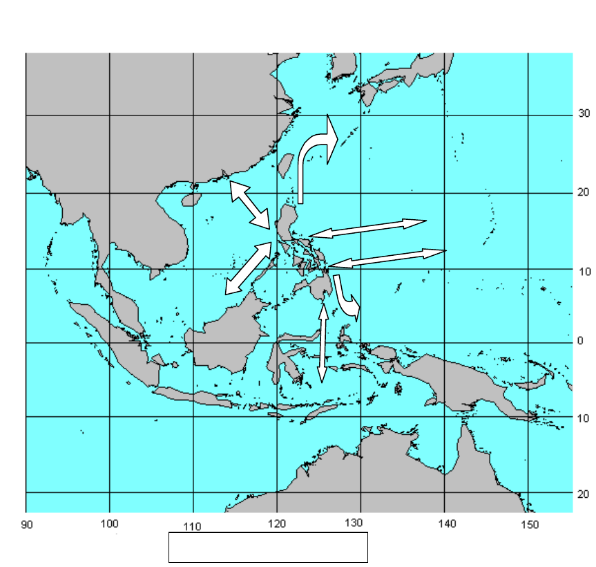
Webb - Cruising Guide to the Phillippines
Page 35
FISHING METHODS
[I need to insert a section in on the various sorts of fishing boats and gear in the Philippines --
both as a matter of interest and for safety:
- Bangkas trawling
- Use of lights and Payao
- Fish traps
- Impoundments for Bangus and other fish raising
- Pearl and other shellfish farms]
PASSAGES TO AND FROM THE PHILIPPINES
If under sail or low powered, it is better if at all possible to avoid trying to go against the wind
and associated currents of the trade winds or the
monsoon.
Routes to and From the Philippines
Draft of 16 June, 2009 16:14
Filcru16.doc
Revision 9
© 2002-09 Conant M. Webb. All rights reserved.
Please send comments and corrections to [email protected].

Webb - Cruising Guide to the Phillippines
Page 36
Hong Kong
This is a fairly common route. The South China Sea is notorious for its short, steep chop
and light airs. There is a lot of commercial and fishing traffic.
Many older charts do not show the offshore oil installations between 50 and 100 miles
offshore of Hong Kong, close to directly on the great circle from Hong Kong to Manila.
They are well lit and excellent radar targets.
To Hong Kong To Philippines
SW Monsoon (Apr-
Sept)
Easy passage from most
points. May wish to coast up
to Bolinao to reduce distance
of passage and potential
exposure to typhoons,
especially during the latter
part of the monsoon. Make
allowance for lee current.
Early in season, make
southing until past
Macclesfield Bank,
then make Easting.
Later in the season,
head as far to weather
as possible, expecting
to make landfall on
NW coast of Luzon,
then coast down. Can
be very time
consuming.
NE Monsoon (Nov-
Mar)
Coast as far N on W coast of
Luzon as Bolinao or even
Cape Bojeador for less severe
NE wind and swell. Beware
of Pratas Reef.
Head directly to
Bolinao or points
South allowing for lee
current.
Japan
It is possible to island hop between the Philippines and Japan with relatively few long legs at sea.
However, the Northern part of the Philippines, Luzon Strait, Taiwan and the southern islands of
Japan are typhoon alley during the summer and fall. Winter is an uncomfortable time to be
sailing as far north as Japan, so the best time for a passage is early in the Spring.
The Kurishiro Current gives a strong northward push on the passage to Japan. On the way
South it may be easier to go via the Marianas or Carolines.
To Japan To Philippines
SW Monsoon (Apr-
Sept)
The best time is in the early
spring, before there is a lot of
typhoon activity.
Consider going via the
Marianas.
NE Monsoon (Nov-
Mar)
A miserable time to try this
trip. Both adverse winds and
winter storms.
You may want to wait
for Spring.
Malaysia, Singapore
To Singapore To Philippines
SW Monsoon (Apr-
Sept)
NE Monsoon (Nov-
Mar)
Indonesia
Moluccas
Draft of 16 June, 2009 16:14
Filcru16.doc
Revision 9
© 2002-09 Conant M. Webb. All rights reserved.
Please send comments and corrections to [email protected].

Webb - Cruising Guide to the Phillippines
Page 37
Melaka Strait
To To Philippines
SW Monsoon (Apr-
Sept)
NE Monsoon (Nov-
Mar)
Belau, Guam, Carolines
To To Philippines
SW Monsoon (Apr-
Sept)
NE Monsoon (Nov-
Mar)
West Coast USA
Northern Route
Central route with Westerlies
To To Philippines
SW Monsoon (Apr-
Sept)
NE Monsoon (Nov-
Mar)
From Western Equatorial Pacific
REGULATIONS
Ports of Entry
The exact status of various ports changes from time to time, and things don't seem to work
according to rules anyway. You can clear in at any of the ports or subports below, but if you
have been in the Philippines or more than 21 days you are supposed to go to a district office at a
larger port to clear out.
In some instances it is preferable to travel overland from a good anchorage to a port of entry or
delay clearing in until you are at a port with a good reputation. I would avoid San Fernando and
Subic, for example. . If you are leaving the Philippines for Malaysia or Hong Kong, the
authorities there don't seem to much care whether you cleared out anyway.
Name Immigration
Office
Port(s) Island Province(s)
Immigration District I
San Fernando District Office Port of San Fernando Luzon La Union, Ilocos Sur
Laoag Field Office Laoag Airport Luzon Ilocos Norte, Abra, Kalinga-
Apayao
Dagupan Field Office Subport of Sual Luzon Pangasinan
Baguio Field Office Baguio City EPZ Luzon Benguet, Mountain Province
Immigration District II
Iligan District Office Luzon Isabela, Nueva Vizcaya, Quirino
Aparri Field Office Port of Aparri
Subport of Claveria
Luzon Cagayan, Ifugao
Basco Field Office Batanes
Immigration District III
Manila District Office Port of Manila
Cavite EPZ
Luzon Metro Manila (ex NAIA), Rizal,
Cavite, Bulacan
Draft of 16 June, 2009 16:14
Filcru16.doc
Revision 9
© 2002-09 Conant M. Webb. All rights reserved.
Please send comments and corrections to [email protected].
Webb - Cruising Guide to the Phillippines
Page 38
Marivales Field Office Bataan EPZ
Subport of Marivales
Subport of Limay
Luzon Bataan
Olongapo Field Office Subic Airport, SBF
Port of Subic, SBF
Subport of Limay
Luzon Zambales
Angeles Field Office Clark Airport
Clark Eco Zone
Luzon Pampanga,Tarlac
Cabanatuan Field Office Subport of Baler Nueva Ecija, Aurora
Immigration District IV
Batangas District Office Port of Batangas Luzon Batangas
Lucena Field Office Subport of Siain Quezon, Laguna
Calapan Field Office Mindoro Occidental and Oriental Mindoro
Boac Field Office Marinduqu
e
Marinduque
Puerto Princessa Field Office Subport of Puerto
Princessa
Palawan
Puerto Galera Officer from
Calapan 3
days a week
Mindoro
Immigration District V
Legazpi District Office Port of Legaspi
Subport of Tabaco
Subport of Jose
Panganiban
Luzon Albay, Sorsorgon, Masbate,
Northern Samar
Daet Field Office Camarines Norte, Camarines
Sur
Virac Field Office Subport of Virac Catanduan
es
Catanduanes
Immigration District VI
Iloilo District Office Port of Iloilo Panay Iloilo, Antique, Guimiras
Kalibo Field Office Panay Aklan
Bacolod Field Office Subport of
Pulupandan
Negros Negros Occidental
Immigration District
VII
Cebu City District Office Port of Cebu
Mactan EPZ
Cebu
Cebu Airport Cebu-Mactan Airport
Dumaguete Subport of
Dumaguete
Negros Negros Oriental, Siquijor
Tagbiliran Field Office Subport of Tagbiliran Bohol Bohol
Immigration District
VIII
Tacloban District Office
Port of Tacloban
Subport of Isabel
Leyte Leyte, Biliran
Maasin Field Office Subport of Maasin Leyte Southern Leyte
Catbalogan Field Office Subport of San Jose Samar Eastern Samar and Western
Samar
Immigration District IX
Zamboanga City District Office Port of Zamboanga
Zamboanga Airport
Subport of Basilan
Mindanao Zamboanga del Norte, Basilan
Pagadian Field Office Mindanao Zamboanga del Sur, Lanao del
Sur
Jolo Field Office Subport of Jolo
Bongao Border
Crossing Station
Sulu, Tawi-Tawi
Immigration District X
Cagayan de Oro
City
District Office Port of Cagayan de
Oro
Mindanao Misamis Oriental, Bukidnon,
Camiguin
Iligan Field Office Subport of Iligan Mindanao Lanao del Norte
Ozamis Field Office Subport of Ozamis Mindanao Misamis Occidental
Butuan Field Office Subport of
Nasipit/Masao
Mindanao Agusan del Norte, Agusan del
Sur
Surigao Field Office Port of Surigao Mindanao Surigao del Norte
Immigration District XI
Draft of 16 June, 2009 16:14
Filcru16.doc
Revision 9
© 2002-09 Conant M. Webb. All rights reserved.
Please send comments and corrections to [email protected].
Webb - Cruising Guide to the Phillippines
Page 39
Davao City District Office Port of Davao Mindanao Davao del Norte, Davao del Sur,
North Cotabato
General Santos City Field Office Subport of Dadingas Mindanao South Cotabato, Sarangani
Mati Field Office Subport of Mati Mindanao Davao Oriental
Cotabato Field Office Subport of Parang Mindanao Maguindanao, Sultan Kudurat
Immigration and Visas
Foreigners of most nationalities likely to be on a yacht are routinely granted a 21 day visitor's
permit on arrival in the Philippines. If you have an opportunity to visit a Philippine consulate
within 90 days before arriving in the Philippines it is possible to get a 59 day tourist visa for a
nominal fee. Visa and tourist permit extensions are available from immigration officers in either
class of port, in two month increments for a period of up to one year, upon payment of fees of
around 1,000 pesos per month. There is a larger fee at six months. There is also an additional fee
for 'express' treatment, which is not mandatory, although some immigration officials
occasionally claim it is.
Customs
There are relatively high tariffs on many items in the Philippines, often in order to preserve a
franchise for local interests. Tariffs are arbitrarily applied, often appearing to be an attempt to
generate bribes. It is usually best to avoid having to have spares and so forth shipped to you in
the Philippines. No duty is charged on vessels in transit, and in practice many yachts remain
indefinitely in the Philippines without any duty being assessed.
Corruption
Official corruption is unfortunately a fact of life in the Philippines. At the level most commonly
encountered by yachtsmen, customs and immigration officers will expect gratuities, usually at a
pretty modest rate. It is particularly a problem in places like Subic Bay or San Fernando, Luzon,
where the behavior of yachts arriving from Hong Kong has caused the going rate to be over ten
times that charged in other places. It's a difficult problem to respond to. If the bribes solicited are
modest, it's probably best to pay with a smile.
When the amounts get higher, it may be wise to object. Asking to see an official schedule of fees
may help, as may asking for the officials to show you their identification and requiring an official
receipt for all fees.
CRIME
Hustles
While the Philippines has its share of violent crime, the cruising yachtsman is far more likely to
encounter various sorts of fraud and deception. Rigged card games and investment
opportunities too good to be true are fairly common. Another trick is to induce the victim to
drink a beverage laced with a powerful animal tranquilizer. Usually the victim is found in a
stupor without watch and wallet.
A Filipino claiming to be a friend or acquaintance, sometimes the immigration officer who saw
you on arrival, may approach you intending to gain confidence for the execution of some
scheme. It is extremely unusual for a bona fide Philippine immigration officer to approach a
tourist on the street. If someone identifies himself to you as an immigration officer in a context
where it is possible that he is an imposter, it would be sensible to insist that they accompany you
to a police station before any discussions take place.
Draft of 16 June, 2009 16:14
Filcru16.doc
Revision 9
© 2002-09 Conant M. Webb. All rights reserved.
Please send comments and corrections to [email protected].

Webb - Cruising Guide to the Phillippines
Page 40
I was approached by a fellow claiming to be an immigration officer, who asserted that he had
been at the desk when I came to the Philippines by air. I had arrived by yacht, and cleared in
several hundred miles away. He proffered a surprisingly good-looking immigration identity
card, but disappeared very quickly when I suggested we stroll down the street to the police
station.
Moneychangers on the street who offer very favorable rates of exchange are usually highly
proficient at sleight of hand.
Lastly, there have been reported cases of foreigners being set up with bar girls who are under age
or who claimed that their customer raped them. Usually the problem is resolved by a sizable
payment.
Violent Crime
[Kidnappings]
[Boloings - generally crimes of passion]
Insurgencies
An important factor in the makeup of all insurgencies in the Philippines is their relationship with
the existing power structure. Much of Philippine politics is not ideological, but a struggle over
the spoils of power. Leaders of insurgents often form overt or covert alliances with political
factions, including the government. A number of prominent Philippine officeholders were coup
leaders or guerrilla leaders at some stages of their careers. Major landowners and businesses
must come to terms with local insurgents in some respect, and in some cases regionally powerful
figures find insurgents to be a useful foil against the authority of the central government.
For the cruising yachtsman, there is not much danger presented by the various insurgencies. It is
wise to stay away from areas that are in a state of unrest (and in some cases open warfare), but in
most of the country people live their lives with little interference.
Insurgencies in the Philippines fall into four somewhat overlapping classes:
1. Bandits seeking economic gain.
2. Communists seeking to change what they see as social inequities resulting from the present
social order, which they describe as semi-feudal neocolonialism.
3. Muslims seeking a better deal for their ethnic groups (it is well to remember that there are 10-
13 different ethno-linguistic groups in the Philippines who are predominantly Muslim, and
that there are often major schisms among members of the same ethnicity.)
4. Vigilantes and 'private armies' seeking to advance the interests of their sponsors, which may
be private parties or governmental agencies.
Particular groups sometimes have characteristics of several of these classes, and frequently
change in character. One example is the Huk survivors who changed from communist peasant
guerillas to gangsters deeply involved in prostitution and drug trafficking in Angeles City.
T
HE COMMUNISTS
In summer of 1920, after the Russian Revolution and as the civil war was winding down, the
Second Communist International Congress in Moscow adopted resolutions proposed by Lenin
and the Indian revolutionary M. N. Roy to promote communist revolution in industrialized
countries through their Asian colonies. The Second International saw British India as their
primary target for subversion, but by 1924 or so Comintern agents began to arrive in the
Draft of 16 June, 2009 16:14
Filcru16.doc
Revision 9
© 2002-09 Conant M. Webb. All rights reserved.
Please send comments and corrections to [email protected].

Webb - Cruising Guide to the Phillippines
Page 41
Philippines to spread the gospel according to Marx and Lenin. The first formal communist party
in the Philippines was formed in 1930 in Tondo. Its founders had previously been involved in
various socialist labor and peasant organizations, including the Philippine Labor Congress, a
union formally affiliated with the Red International of Communist Unions.
It would be a mistake, however, to see the various communist movements in the Philippines only
as part of Moscow (and, later, Beijing) - directed conspiracies. While there has clearly been aid of
various sorts from foreigners from time to time, the insurgencies have also drawn support from
nationalistic sentiment and unideological (or certainly non-communist) rebellion against
oppression. The Huks drew much of their support from rebellion against the Japanese and their
puppet forces, and, after the war, from peasant rebellion. The NPA could have never prospered
without Marcos' repression. Now, in 2001, the NPA seems to deliberately recruit among ethnic
minorities who feel (with some reason) that they do not get fair treatment.
Historical Sketch
With the Japanese invasion and rapid collapse of American and Filipino resistance in late 1941
and early 1942, the core of a communist inspired peasant resistance to landlords in central Luzon
formed the Hukbo ng Bayan Laban sa Hapon, (People's Anti-Japanese Army) also known as the
Hukbalahap or simply the Huks. The Huks fought hard against the Japanese, one of many
resistance movements in the Philippines. After the war the Huks were disarmed and treated as
bandits by the American military, unlike some other resistance forces that perhaps better
deserved such treatment.
After a brief foray into open participation in the political process ending with the badly flawed
1949 election, the Huks returned to guerilla war against the Philippine government in Central
Luzon. By the mid '50s, the Huks had been mostly suppressed by a combination of military
action and some modest land reform and relocation of landless Huks to Mindanao. The Huks
survived in some form until the late 1960s, and the founding of the New People's Army (NPA).
The NPA looked to China rather than Russia as its inspiration. It grew rapidly as Ferdinand
Marcos moved to more purely authoritarian rule in the early 1970s, but had severe setbacks in
the late 1970s as a result of effective military and police action. The NPA succeeded far better
than the Huks in bringing their activities to many parts of the Philippines, but badly lost support
after the EDSA revolution in 1986. There are still probably several thousand NPA fighters, and
there are still clashes between Philippine military and police forces and the NPA.
The NPA
NPA in 2001
The New People's Army (NPA) is the military wing of the Communist Party of the Philippines
(CPP). It is currently active in some rural areas, and seemed to be experiencing a mild
resurgence during the Estrada administration after its steady decline since the late 1980s. Some
of the resurgence is probably a result of government resources being diverted to Mindanao and
the Sulus for operations against MILF base areas and the Abu Sayyaf Group. Some is also
attributable to the failures of the Estrada government.
The NPA continues to attack police and military targets and to assassinate local government
officials. There may be some grounds for concern over several recent reports of NPA fighters
operating jointly with MILF forces in Mindanao, which may indicate the possibility of broader
cooperation. In 1999 the US State Department estimated the NPA's strength was between 6,000
and 8,000 fighters. NPA cadres have been reported to have 'infiltrated' recent demonstrations
calling for President Estrada to resign for the purpose of creating disruptions that would be
Draft of 16 June, 2009 16:14
Filcru16.doc
Revision 9
© 2002-09 Conant M. Webb. All rights reserved.
Please send comments and corrections to [email protected].

Webb - Cruising Guide to the Phillippines
Page 42
blamed on government forces, but no such disruptions seem to have occurred. [Add discussion
of the far left's participation in 'EDSA II' in contrast to their absence from EDSA I.]
Jose Maria Sison and Early Days
Jose Maria Sison was the founder and seems to remain the principal leader of the NPA from his
self imposed exile in the Netherlands. He was born in 1939 in Cafugao, Ilocos Sur. He studied
political science at the University of the Philippines where he began his radical leftist and
nationalist career. In 1959 he founded the Student Cultural Association of the University of the
Philippines (SCAUP), which was apparently intended to allow him to continue his involvement
in student politics. After his graduation with a BA cum laude in 1960 he was briefly employed by
UP as an instructor, but was dropped from the faculty for his political activities. In 1963 he
joined the old Communist Party of the Philippines (Partido Kommunista ng Pilipinas--PKP). The
PKP was then in decline in the wake of the failure of the Huk insurgency. Sison became head of
the PKP's youth department and founded the Kabataang Makabayan (KM). On October 24, 1966
Sison was involved in demonstrations against the Vietnam War and a summit meeting between
US president Lyndon Johnson and leaders of Australia, South Vietnam, South Korea, Thailand,
Malaysia and the Philippines. The demonstrations were violently suppressed by police, and
Sison and others were arrested.
By the late 1960's Sison campaigned for 'rectification' of the PKP 's ideology from Moscow to one
more in line with Beijing. The leadership (Lava) eventually expelled Sison and his followers
from the party.
Sison and a small group of followers formally founded what is now called the Communist party
of the Philippines (CPP) as the CPP (Maoist) on December 26, 1968, Mao's 75
th
birthday. The
schism was based on both Sison's personal enmity for Lava and other PKP leaders and
ideological factors. There were similar breaks from Moscow to Beijing among several communist
movements around the world at about this time. In early 1969 Bernado Buscayno ('Commander
Dante') became commander of the NPA by defecting to the CPP with his unit of some sixty
former Huk fighters. Some sources claim that the then-governor of Tarlac Province, Benigno
Acquino, jr., and/or Congressman Jose Yap were instrumental in introducing Buscayno to Sison,
and that 'Commander Dante's' renegade Huks had been used to intimidate voters on behalf of
Acquino and Yap.
Initially the NPA attempted to form a secure 'base area' in Tarlac Province of Central Luzon,
where the Huks had long been active and where Acquino was then governor. It has been
suggested that early funding and refuge was given the NPA by Benigno Acquino's in-laws on
their vast Hacienda Lusita in Tarlac province. In any event, the fledgling NPA made fairly rapid
progress in its first few months, increasing to perhaps 300 fighters.
The government had 'demilitarized' Tarlac province in November of 1968, believing that the
Huks had been suppressed. As word of NPA activities began to reach the government, it
thought it had another resurgence of the Huks to deal with, and in April of 1969 recommenced
counterinsurgency operations. In June documents were captured that showed that a new force
espousing a Maoist ideology was involved. The military redoubled its efforts, and the fledgling
NPA forces were nearly encircled and destroyed by the military. The survivors fled to the
mountainous Isabela Province in Northern Luzon to regroup.
The situation changed with the 'first quarter storm' demonstrations and riots of January - March
1970 in Manila. Sometimes characterized as 'an outpouring of popular anger' there was certainly
also an element of manipulation by Marcos' political opponents. It is still an open question who
was behind the two hand grenades thrown at the speakers' platform of the Liberal Party rally at
Plaza Miranda in downtown Manila in August 1971. Ten were killed and 66 wounded,
Draft of 16 June, 2009 16:14
Filcru16.doc
Revision 9
© 2002-09 Conant M. Webb. All rights reserved.
Please send comments and corrections to [email protected].

Webb - Cruising Guide to the Phillippines
Page 43
including virtually all of the Liberal Party leadership except for Benigno Acquino, who was late
attending the rally. Some claim Marcos was behind the grenading, and some claim the NPA was,
and that it had warned Acquino. Marcos suspended habeas corpus in response.
As the Marcos regime increased its repressive measures against any and all opposition,
culminating with the declaration of martial law in 1972, the NPA/CPP became one of the few
options for opponents of the regime. Unlike the peasant leadership that had characterized the
Huks, the NPA/CPP was able to recruit a fair number of university students. Sometimes these
sons and daughters of the middle and wealthier classes were shocked to discover how the vast
majority of rural Filipinos lived. By 1972 the NPA had grown to some 950-1,300 fighters.
The NPA had apparently approached the Chinese for material support as early as 1969, some of
which was forthcoming. On July 5, 1972 the fishing trawler M/V Karagatan was interrupted by
Philippine Constabulary forces while unloading arms on the East Coast of Isabela Province. In
the ensuing firefight, the NPA was able to save only about 200 of the 1200 Chinese-made M-14
rifles aboard. A second attempt came to grief in 1974 when its NPA crew put the Doña Andrea
aground on Pratas Reef while on their way to China. The crew was picked up by a Hong Kong
bound freighter, where the local authorities had no difficulty identifying them but quietly
handed them over to the Chinese. Marcos suppressed both incidents, but dispatched Imelda to
woo Chairman Mao and in 1975 negotiated an end to Chinese support for the NPA in exchange
for diplomatic recognition of Beijing.
In April 1973 the CPP founded the National Democratic Front (NDF) as a political front
organization. The NDF was intended to assist in generating grassroots support for the CPP by
forming alliances with various organizations with compatible aims to the CPP. Other front
organizations aimed at students, workers and the church were formed under the NDF umbrella.
The NDF's affiliation with the CPP was well known, forcing the NDF to remain underground.
Decentralization and Growth
Sison and Buscayno, were arrested and more than a dozen CPP and NPA leaders were captured
or killed during 1976 and 1977. This led to a deliberate policy of decentralized leadership among
the NPA, which proved reasonably effective.
The Huks had made few and relatively ineffectual efforts to establish operations in areas other
than central Luzon, allowing the government to concentrate its forces and destroy the insurgents.
Consequently, the NPA pursued a strategy of dispersing their efforts in various rural and poor
parts of the Philippines, principally Northern Luzon, Bicol, Samar and Northern Mindanao.
The 1980's - Purges and Peoples' Power
[To come]
The 1990's
Edsa II
Ideology
The CPP espouses a classical Maoist line, leaning heavily on Mao Zedong's writings, as adapted
for Philippine conditions largely by Sison in his book Philippine Society and Revolution,
published in 1970 under his first nom de guerre, Amado Guerrero. "Under the absolute
leadership of the Party, the NPA wages a protracted people's war, made possible and dictated by
the chronically crisis-ridden semicolonial and semifeudal conditions of the Philippines",
according to a 1994 article in what seems to be a quasi-official NPA website. The ultimate aim is
to overthrow the Republic of the Philippines (referred to as the US-Marcos, US-Acquino, US-
Ramos, or US-Estrada Regime, as appropriate) by "encircling the cities from the countryside and
Draft of 16 June, 2009 16:14
Filcru16.doc
Revision 9
© 2002-09 Conant M. Webb. All rights reserved.
Please send comments and corrections to [email protected].
Webb - Cruising Guide to the Phillippines
Page 44
accumulating strength until it becomes possible to wage nationwide offensives and seize the
cities." Presumably this is to be followed by the establishment of 'people's democracy' and
eventually the ‘pure communism’ that no communist government has yet been able to deliver.
Other Communist Groups
Alex Boncayo Brigade
[More to come on various communist lost commands]
[Muslim Groups]
Piracy
The entire Southeast Asian archipelago has provided an ideal environment for piracy for
centuries, and has a reputation that is likely to persist for a long while irrespective of the facts.
The blanket statements about all of the region being unsafe that one might hear at a yacht club
bar in Sydney, San Francisco or Auckland obviously need to be taken with a truckload of salt.
The well organized syndicates who have been responsible for the disappearance of tankers and
cargo vessels along with their crews in the last decade in Southeast Asia are uninterested in a
target as small as a yacht. There simply isn’t the same value in a yacht as there is in a merchant
vessel carrying something like diesel fuel or metal ingots, readily marketable, valuable and hard
to trace. In these operations the money is big enough to procure the protection of high
government officials and law enforcement authorities. These gangs to pick their targets with
excellent knowledge of their cargoes, crew and schedules, and in some cases seem to have been
able to delay loading or clearing of ships to set them up for later interception indarkness.
Smaller operations can pose a risk to yachts, but the actual incidence is very small. By all means
avoid Southwestern Mindanao and the Sulu Archipelago. In other parts of the Philippines piracy
no more of a problem for the cruiser than in most other parts of the world. The Philippine Navy
and Coast Guard work at trying to eliminate the problem, but they have limited resources.
While they may solicit modest gifts, they have not generally been implicated in piracy.
When evaluating reports of piracy it is wise to consider other explanations for the reports. There
have been a few killings and disappearances in the last twenty five years that may have been
piracy or may have been garden variety spousal murder. Some hostile acts against yachts have
been fishermen whose gear was recklessly damaged by the yachts. Yachtsmen brandishing arms
may have provoked some.
On the topic of carrying arms aboard, my sense is that it is wiser to be unarmed. Effective use of
weapons requires regular practice and a delicate sense of who is truly hostile and who is not.
Both of these are quite difficult on a small yacht. I have seen heavily armed men in bangkas
several times in the Philippines. In every instance they turned out to be military or police
patrols. Consider how unwise it would be for a yachtsman to open fire on six or eight men
armed with light automatic weapons and grenade launchers.
The last reported piratical attack on a yacht in the Philippines seems to have been
[Peer Tangvald SSCA 79-168 -- wife killed allegedly in attack in Sulu Sea]
1980s - attack on large German yacht leaving Iloilo after refit.
Gangs operating in entrance to Manila Bay (in 1980s?)
Current advice on piracy can be had [KL Piracy Center, MARADS, State Department, Media
(caution about sensationalist reporting) and other yachties]
Draft of 16 June, 2009 16:14
Filcru16.doc
Revision 9
© 2002-09 Conant M. Webb. All rights reserved.
Please send comments and corrections to [email protected].

Webb - Cruising Guide to the Phillippines
Page 45
[Caution about unnecessary display of wealth, reminder of the relative poverty in the
Philippines, note that the situation can be fluid, possible effect of further unrest in Indonesia]
[I'm still not clear on the correct balanced view of this issue]
HEALTH
Disease
MALARIA
STD
S
The Philippines are a popular destination for sex tourism. In most towns of any size there are
girlie bars, and at some levels of society a very freewheeling approach to sexual matters.
Combined with an obstructive attitude on the part of the Roman Catholic church to reasonable
education and measures such as free or subsidized distribution of condoms, poverty, ignorance
and mediocre medical care, it is not surprising that there are many and varied sexually
transmitted diseases present in the Philippines, including HIV/AIDS, hepatitis B, herpes,
syphilis and gonorrhea. If you partake, use a condom and be careful.
F
OOD & WATER BORNE DISEASES
C
IGUATERA
TB
Like many developing countries, tuberculosis is still endemic in the Philippines, although there is
a reasonably effective program under way to try to eliminate it. The risk to a healthy, well
nourished person not in prolonged contact with a carrier is small, and the varieties common in
the Philippines are not drug resistant. However, if you suspect that you might have contracted
it, make sure your doctor knows you may have been exposed.
Medical Kit
Hazardous Marine Life
Dangerous marine life is not a terrible problem in the Philippines. There are the usual risks
associated with coral waters. The basic rule is to be very cautious about touching anything
underwater that you don't recognize.
J
ELLYFISH
Jellyfish of genus Chirodropia, very similar to Chironex Fleckeri, the famous 'box jellyfish' of
Northern Australia, are present in warmer Philippine waters. In late summer they have been
found as far North as Bolinao and Lingayen Gulf. The local names are 'salabay' or 'cubo'. These
jellyfish are not as dangerous as their Australian relatives, but there are said to be as many as 5-
20 deaths in the Philippines each year attributed to their stings.
The tentacles (and in some cases the bell) of jellyfish contain stinging cells (nematocysts) that
inject a venom into the victim when given the right stimulus, such as contact with exposed skin.
The immediate effect is intense pain at the site of the sting, and generally a reflexive attempt by
the victim to remove the tentacles adhering to the skin. Adherent tentacles are a convincing sign
that a Chirodropid jellyfish stung the victim. In a severe sting the victim may lose consciousness
and stop breathing as soon as 5-10 minutes after being stung. There is a characteristic 'whip
weal' mark: a white line where the tentacle touched surrounded by red inflammation. The color
can be masked by skin pigmentation, however, and the inflammation takes some time to
Draft of 16 June, 2009 16:14
Filcru16.doc
Revision 9
© 2002-09 Conant M. Webb. All rights reserved.
Please send comments and corrections to [email protected].

Webb - Cruising Guide to the Phillippines
Page 46
develop. In a fatal envenomation, the victim may die before there is time for the inflammation to
arise.
Most Chirodropid stings are on the legs in under 2 m of water, typically in hot, still water in a
sheltered inlet over a sandy bottom. It is very difficult to see Chirodropid jellyfish in the water,
but the jellyfish have rudimentary eyes and will avoid a slow moving wader or swimmer if they
can. Children playing in the shallows are particularly at risk because their small body size
results in a greater concentration of the venom.
If a Chirodropid sting is suspected, the first thing to do is to prevent the victim from being stung
more. The adherent tentacles will still contain substantial numbers of undischarged nematocysts,
containing additional venom that may seriously worsen the victim's condition if they are allowed
to discharge. The victim must be restrained from attempting to remove the tentacles, as they will
likely trigger further envenomation as well as spreading the envenomation to the victim's
forearms and the back of his hands. It seems that the skin on the palms and fingertips is too thick
for significant numbers of nematocysts to penetrate. Never rub the affected area with sand or
bare hands and never apply alcohol, either of which will cause further nematocyst discharge.
The Philippine folk remedy is to apply calamansi juice. I am unaware of any evidence whether
or not this works. The undischarged nematocysts are best dealt with by rinsing them with
vinegar (5-10% acetic acid) for at least 30 seconds. If no vinegar is available, the tentacles can be
gently removed with tweezers or bare hands if necessary. With bare hands the rescuer may feel
some tingling in the fingertips, but should suffer no serious adverse effect because of the thicker
skin. It is unnecessary to remove tentacles that have been inactivated with vinegar, but it may be
useful to save a sample for identification of the Chirodropid species involved.
Keep the victim as quiet as possible, and watch to make sure that his condition does not worsen.
Give CPR if necessary. If the sting is serious (covering the surface of more than half of a limb,
impairing consciousness or breathing, hypotension or irregular heartbeat) apply bandages and a
splint to compress the affected area and immobilize it. The effect of compression and
immobilization is to reduce the rate that the venom is dispersed throughout the body from the
stung area by restricting circulation in the affected area and eliminating the 'muscle pump' effect.
Evacuate to a good hospital if possible. Be cautious if a victim who was in great pain and
struggling becomes quiet and cooperative. This may indicate the onset of impairment of
consciousness associated with life threatening stings.
There is an antivenin available in Australia for Chironex Fleckeri that has been used with great
success both to relieve the symptoms of envenomation and to reduce the scarring that often
results from a bad sting. Its usefulness for the Chirodropid species found in the Philippines is
not clear.
Other jellyfish in the Philippines may give a painful sting, but are probably not likely to cause
serious problems. Vinegar can be used to prevent further envenomation, but other treatment
will hopefully be unnecessary.
C
ONE SHELLS (CONUS)
A few species of the genus conus are found in the Philippines. Cone shells all have a stinging
tooth on the end of their proboscis that can protrude from the narrow end of the shell. In some
cases the venom injected through the tooth can be fatal to people. The symptoms begin with
[ischemia], cyanosis and numbness and tingling or a sharp stinging or burning sensation in the
area of the wound. Numbness then spreads rapidly, involving the entire body and is
pronounced about the lips and mouth. In severe cases paralysis and death may ensue. First aid
is compression and immobilization bandaging, followed by respiratory and cardiac support as
available. Immersion in hot, but not scalding water may help to relieve the pain.
Draft of 16 June, 2009 16:14
Filcru16.doc
Revision 9
© 2002-09 Conant M. Webb. All rights reserved.
Please send comments and corrections to [email protected].

Webb - Cruising Guide to the Phillippines
Page 47
The only way that anyone gets stung by a cone shell is by handling it. Don't pick up a cone shell
with your bare hands. The old story that it is safe to pick up a cone shell by the big end is not
completely accurate. The proboscis is long and flexible, and in some cones can easily reach the
big end.
L
ION AND STONEFISH (SCORPAENIDAE)
There are a variety of fish with stinging spines of the Scorpaenidae family in the Philippines.
There are three groups within the family: the beautiful pterois (lionfish, zebrafish; lolong, tandang)
with long slender spines and fins, scorpaena (scorpionfish; tamalingking) with shorter, more robust
spines and synanceia (stonefish; lupo) with stout, short spines. This is pretty much in the order of
severity. All have sharp dorsal spines that inject venom when the loose sheath that covers the
spine is pushed back. With pterois and scorpaena the most likely cause of a sting is handling the
fish in ignorance or accidentally. With synanceia the most likely cause of a sting is stepping on it.
Stonefish are exceptionally well camoflauged and are often present in shallow coral waters. It
may be a good idea to wear some sort of shoes if wading around rocky or corraline shallows.
In all cases the sting is extremely painful, and may involve the entire limb and lymph nodes.
Generally the pain peaks in 60-90 minutes, and will last about 12 hours if untreated.
S
HARKS
Compared to places like Queensland or the Solomons, there are very few sharks in the
Philippines, possibly because of intensive fishing. The survivors pose little risk to swimmers.
There are a few dangerous sharks, notably the tiger shark (Galeocerdo Cuvier), but attacks are
quite rare.
C
ROCODILES
In Surigao, Siargo and possibly close to North Borneo there are occasional reports of saltwater
crocodile attacks. Crocodiles can be extremely dangerous to a swimmer or wader. It would be
wise to ask the local population about recent sightings before swimming in these areas. In most
Philippine languages crocodile is ‘buaya’.
S
EA SNAKES
Several species of sea snake are found in the Philippines. Some are very poisonous, but they are
extremely unlikely to bite a person. Their mouths are quite small, and it is physically difficult for
them to bite a person. Unless badly provoked they are not aggressive, although sometimes they
will approach a swimmer or diver out of curiosity.
In the unlikely event of a bite, use compression and immobilization bandaging.
F
IRE CORALS (MILLEPORA SP.)
Fire corals appear in a wide variety of shapes and colors. Some varieties are encrusting and some
have various branching forms. If you touch it with bare skin, you will quickly understand how it
got its name, as ther is an immediate burning sensation. Later there will be a red welt that
sometimes blisters. Fire corals generally like areas with substantial current and fairly strong
sunlight. An anchor line or a mooring is perfect. The stings do not present a serious health risk,
but it is fairly common for the encrusting types to grow on anchor and mooring chains that have
been in place for a month or more. Gloves are probably in order if you are working with
something that is likely to be encrusted.
Some recommend hot water or meat tenderizer as a first aid measure.
Draft of 16 June, 2009 16:14
Filcru16.doc
EMERGENCIES
Revision 9
© 2002-09 Conant M. Webb. All rights reserved.
Please send comments and corrections to [email protected].
Webb - Cruising Guide to the Phillippines
Page 48
Self Reliance
The best way of handling emergencies is to prevent them from occurring in the first place. The
Philippines is not the place for you if you expect to have someone around to bail you out of
whatever trouble you get into.
SAR
Evacuation Assistance/SAR
AFP SAR HQ,
GHQ Philippine Air Force
Villamor AFB, Pasay City
Metro Manila
(63 2) 911 7996; 911 6385
Mayday Procedures
Hyperbaric Chambers
Don't expect these to be in working order without checking first.
Subic Bay
(63 47) 252 7952
Subic Bay Freeport Zone
SBMA, Olongapo City
Contacts: Lito Roque, Rogelio Dela Cruz
Manila
(63 2) 920 7183; 921 1801 loc 8991
AFP Medical Center
V. Luna Road
Quezon City
Contacts: Jojo Bernado, M.D., Fred C. Martinez
Cebu
(63 32) 310 709 (?) (Chamber) 232 2464-8 loc. 3625
VISCOM Station Hospital
Camp Lapu Lapu
Lahug, Cebu City
Contacts: Mamerto Ortega, Macario Mercado
OVERHAUL AND REPAIR FACILITIES
There is a scarcity of really good yacht hauling and repair facilities in the Philippines. It certainly
possible to safely haul your boat and have various kinds of work performed, but you are likely to
be promised much more than the actual capability of most yards. Be especially cautious when
evaluating hauling arrangements, especially renting cranes from third parties.
Most workers need to be closely supervised, and the hammer, pliers and pry bar school of
mechanics is far too common.
Cagayan del Oro, Mindanao
Subic (Travel lift)
Manila Yacht Club (Maybe...)
Marivales
Port Sual
Draft of 16 June, 2009 16:14
Filcru16.doc
Revision 9
© 2002-09 Conant M. Webb. All rights reserved.
Please send comments and corrections to [email protected].

Webb - Cruising Guide to the Phillippines
Page 49
Maya Maya (planned)
Port Carmen
Cebu Yacht Club
Iloilo
Payao, Guimiras (slipway for multihulls only)
[Others?]
YACHT CHARTER
There are no large charter operations in the Philippines. Bareboat charter has not come to the
Philippines. There are several single boat operations doing crewed charters.
L
A ESPERANZA
http://dgte.mozcom.com/esperanza
Baras Beach Resort (see page 95) can refer you to a few crewed charters.
DELIVERY SKIPPERS
There are a number of foreigners residing in the Philippines who do yacht deliveries on occasion.
Inquiries can be directed to the major yacht clubs. Check references carefully.
Draft of 16 June, 2009 16:14
Filcru16.doc
Revision 9
© 2002-09 Conant M. Webb. All rights reserved.
Please send comments and corrections to [email protected].

Webb - Cruising Guide to the Phillippines
Page 50
THE REGIONS
This book divides the Philippines into six
regions as indicated on the chartlet to the left.
The Northwest Region includes Manila Bay,
and the west coast of Luzon from there to
Cape Bojeador. It is mostly of interest to
sailors based in Manila and Subic, and those
travelling to or from China and Japan. The
Northeast Region covers the northern and
eastern coasts of Luzon and its offlying
islands. Yachts do not often visit it. [And is
not yet dealt with very comprehensively here.]
The East Central region includes the heart of
the Visayas, and covers the principal
approaches to the San Bernadino Strait and
the Surigao Strait from the west. The West
Central Region includes the islands of the
Sibuyan Sea and the resort port of Puerto
Galera. There is excellent cruising in the
Southwest Region - Palawan, the Calamain
and Cuyo Islands The northern part of this
area has some of the best cruising in the
Philippines. It is frequently described as
'magical'. The Southeast region includes The
Sulu Archipelago and the Western part of the
island of Mindanao, which presently are probably too dangerous for cruisers because of conflict
between government troops and various groups of Muslim insurgents and general lawlessness.
The north and east coasts of Mindanao are more peaceful, although it is probably a good idea to
aquaint yourself with recent developments before going.
WEST
CENTRAL
EAST
4708 Philippines, Southeastern Part
4707 Philippines, Southwestern Part
Draft of 16 June, 2009 16:14
Filcru16.doc
Revision 9
© 2002-09 Conant M. Webb. All rights reserved.
Please send comments and corrections to [email protected].

Webb - Cruising Guide to the Phillippines
Page 51
NORTHWEST REGION
This area covers the west coast of Luzon
from Manila Bay to Cape Bojeador. The
cruising yacht is most likely to be here while
traveling between the Philippines and China
or Japan.
Vigan
Vigan
San
Fernando
The wind and swell conditions are very
much influenced by the season. During the
NE season the coast is pretty benign,
although the swell can make some
anchorages rolly. During the SW season
much of the coast is a lee shore, and few
anchorages other than the best will be
tenable. The swells tend to get larger in the
North after the SW monsoon has been
blowing strongly for a while. Cape Bojeador
has something of a reputation for rough seas.
The typhoon refuges in the section are
marked on the chartlet to the left. Close to
the region, Hamilo Cove (page 69) is a
typhoon refuge just South of Manila Bay. On
the North Coast of Luzon, Aparri (page 63) is
fair shelter if it's not too bad a blow. Port San
Vicente is further East along the N Coast.
The major ports of entry in the region are
Manila, San Fernando and Subic Bay. There
are subports at Sual and Marivales. [It must
be possible to clear in at Port Salomague?]
The region is discussed from Manila north.
Manila Bay
Phil 4236A Fairways and Anch. -- Manila Hbr
Phil 4211 Approaches to Manila Bay
Phil 4255 Manila Bay and Approaches [Marirelo]
Phil 4243 Manila Bay -- Manila to Cavite
Manila Bay is filthy, with lots of fishing and
commercial traffic, plastic bags and fishing
bangkas. Metro Manila now has a
population of at least 10 million, and is
struggling with typical developing country
problems of pollution, traffic, overcrowding,
crime and the like. Marivales and
Corregidor can be interesting stops, but
otherwise the bay has few attractions for
yachts. Manila is the Tagalog heartland -- its
Pasig River is the river probably meant in the
original 'taga ilog' - '[the language of] the
people of the river'.
Draft of 16 June, 2009 16:14
Filcru16.doc
Revision 9
© 2002-09 Conant M. Webb. All rights reserved.
Please send comments and corrections to [email protected].

Webb - Cruising Guide to the Phillippines
Page 52
MANILA YACHT BASIN AND MANILA YACHT CLUB (14° 34'N, 120° 58'E)
Phil 4236A Fairways and Anch. -- Manila Hbr
Phil 4211 Approaches to Manila Bay
Phil 4255 Manila Bay and Approaches [Marirelo]
Phil 4243 Manila Bay -- Manila to Cavite
The charted Manila Yacht Basin is used by the Manila Yacht Club, the Philippine Navy, and
some small fast ferries.
The Manila Yacht Club has moorings, a 16 ton travel lift and small hardstand, 35 ton slipway,
fuel pier, bar and restaurant, and fairly good security. Recent work on the breakwaters of the
yacht basin look like they will significantly improve the safety of yachts in the event of a
typhoon. The club seems somewhat ambivalent about visiting yachts, and has modified its
policies several times in the last few years. As of November 1999, the Manila Yacht Club
permitted visiting yachts to moor for the first week free, and then at an accelerating schedule
depending upon whether the owner is a member of a yacht club with a reciprocity arrangement.
Visiting yachts pay three times the members' rates for hauling, slipping and so on, but negotiate
for repair work on the same basis as members. Non members pay a 20-30% premium on food
and drink. [ VHF 12?]
Manila Yacht Club
2351 Roxas Boulevard
PO Box 1085
Manila, Philippines
Tel 632 521 4457
Fax 632 521 6434
Email: [email protected]
Some boats have been in places like the mouth of the Pasig River, but I'd give it a miss.
CORREGIDOR (14° 23'N, 120° 35'E)
The best anchorage is in the small cove on the North side, off the pier. The bottom profile is quite
steep. The island is a pleasant place for walking around, and there is an interesting museum in
the old world war II fortifications.
EL FRAILE I (14° 18'N, 120° 38'E)
Not a cruising destination as such, the WWII fortifications on this island make it resemble a
warship at a distance.
CAVITE HARBOR (14° 29'N, 120° 54'E)
There are some commercial shipyards here that will sometimes work on yachts. Otherwise not
much to recommend it.
PUERTO AZUL YACHT CLUB (14° 17'N, 120° 42'E)
Puerto Azul, Ternate
Cavite
Office: 15/F PCI bank tower II, Makati Avenue, Makati city
Tel. No.: (632)813-3690 to 98 ]
M
ARBELLA MARINA (BAY TO SW OF AZUL)
Has Marcos-era resort once notorious for the white sand that Imelda had brought in for a beach
party. The marina is reported to be still operating.
Marivales to Lingayen Gulf
The West coast of Manila Bay and all of Bataan is predominantly Tagalog.
Phil 4210 Dasol Bay to Capones Is [Sta Cruz Hbr, Iba Anch]
Draft of 16 June, 2009 16:14
Filcru16.doc
Revision 9
© 2002-09 Conant M. Webb. All rights reserved.
Please send comments and corrections to [email protected].

Webb - Cruising Guide to the Phillippines
Page 53
Phil 4266 Ports Masinloc and Matalvi and Palauig Bay
From Subic to Santa Cruz is Zambales Province, with a mixture of Tagalog, Zambal and Ilocano
Speakers.
MARIVELES (14° 26'N, 120° 29'E)
Fairly well protected, except from the South. Anchorage can be had anywhere in the bay,
although sometimes the holding is indifferent. Bataan Marina is reported to have closed.
[Anybody recent news?]
[The Bataan Marina has a small basin with room for a few yachts to lie alongside and a
hardstand. The basin has had repeated problems with silting, and has severe surge in strong
southerly winds. A crane must be rented in order to haul boats. Be cautious about the cranes, as
there have reportedly been a number of near misses. The stands I saw on the hardstand were
inadequate to be safe in a bad blow. Having said that, there are some excellent tradesmen in the
area from various commercial repair and shipbuilding operations. The bar and restaurant at the
marina are pleasant, and the marina is about a five minute tricycle ride to town.
Bataan Marina
Bataan Export Processing Zone, Bataan
Tel. No.: (63)(47) 561 3944 /45, Fax: (63)(47) 935 5145
E-mail: [email protected]
Marina Manager: Frank Backes / Tom Dreyfuss]
Marivales has a fairly large market as well as some hardware stores and the like. A ferry runs
directly to Manila and there is also bus service.
It is said that in the early 17th century a 17 year old novice named Maria Velez at the Santa Clara
Convent in Manila eloped with a Franciscan monk to Camaya, as Marivales was then called.
They intended to catch the Acapulco galleon there for Mexico. Unfortunately, the galleon did
not sail immediately, and the lovers were apprehended by a notary and a dozen arquebusiers
sent in pursuit by an alderman of Manila. The monk was sent to teach religion and morality to
the 'Visayan tribes' and the nun was sent back to the City of Mexico for perpetual reclusion in a
convent. It is said that this led to the names of Corregidor (Alderman) Island, which lies between
the rocks known as Fraile (Friar) and Monja (Nun), and that Mariveles is named after Maria
Velez.
SUBIC BAY (14°45' E, 120° 15'N)
The old US Navy base at Subic Bay has been closed since 1991. It is now a 'Free Port'
administered by the Subic Bay Management Authority (SBMA)[tel?]. Vessels are required to
report in and out of the freeport [at? procedure?]. Call Subic Bay Port Operations on VHF 16
when passing Grande Island. Subic is a port of entry, but the 'unreciepted fees' tend to be very
high. If behind the breakwater at the Subic Yacht Club there is adequate shelter for a typhoon,
but other places in the bay are more problematic. The Olongapo River used to be viewed as a
typhoon refuge for small craft, but has silted up since the eruption of Mt. Pinatubo.
Supplies of all sorts are readily available inside the freeport or in the neighboring town of
Olongapo. Most of the 'duty free' shops in the freeport do not seem to be significantly less
expensive than outside the freeport, but the selection may be better than in many other parts of
the Philippines. There are literally dozens of restaurants. Many of the sailing and flying
fraternity meet at Vasco's, which is close to the bunkering facility on the road to the airport. Fuel
in quantities under five thousand liters is no bargain, but large power yachts can sometimes save
a couple of pesos a liter at one of the two fuel piers. [Names, pos'ns]
Draft of 16 June, 2009 16:14
Filcru16.doc
Revision 9
© 2002-09 Conant M. Webb. All rights reserved.
Please send comments and corrections to [email protected].
Webb - Cruising Guide to the Phillippines
Page 54
[History; keep an eye out for smuggler loading cigarettes for (?) China in their fast 78-80' steel
boats]
The Subic Bay Yacht Club [located] is a very ambitious recent development with a huge
clubhouse and marina, several restaurants, deli, pool, tennis courts and so forth. The
development is now in serious financial difficulties. In the past it did not welcome visitors, but
now allows visiting yachts to stay in the marina, at exorbitant prices and with little access to the
facilities. There are many vacant berths. Call Subic Bay Yacht Club Marina on VHF 72. The
future is uncertain. At the South end of the same basin as the SBYC is Watercraft Venture
Corporation (Bldg 1031, Rizal Hi-way, Subic Bay Freeport Zone, Tel (63) 047 252 1739 or 1740.
Ray Wolff, manager). Watercraft has some sort of franchise from the yacht club as a repair
facility. Watercraft has a small floating dock with a dozen slips or so and a couple of moorings
which are sometimes made available to visiting yachts, particularly if they have some work
performed. There is a [capacity?] travel lift and a hardstand. Reportedly the work performed by
Watercraft Ventures is expensive and of highly variable quality. The yacht basin is reasonably
convenient to stores and restaurants.
Subic Bay Yacht Club
Subic Bay Special Economic Zone, Olongapo, Philippines
Tel. No.: (63)(47)2525211, Fax: (63)(47)2526587
Manila office: (632)8115735 Fax: (632)8115730/4
email: [email protected]
Commodore: Vic Vic Villavicencio
Marina Manager: Danny Calapatia
[Subic Bay Waterfront Development Corp., 15th Fl Pacific Star Bldg, Sen. Gil J. Puyat cor Makati
Ave., Makati tel 02 811 5730-33 fax 2 811 5192 5194 5735]
It is also possible to make arrangements (with SBMA?) to have a boat hauled by one of the large
freeport cranes, or to lie alongside one of the many less used piers. [who to contact?]
In light Northerly weather almost any anchorage in the bay is acceptable, although inside the
freeport the SBMA has a marine patrol which may chase you away. Permission to anchor is
supposed to be obtained from [SBMA VHF 16?], but sometimes the patrol chases you off
anyway. In rough weather or the Southerly season there can be a nasty swell in the bay.
Inside the freeport, in Northerly weather the best anchorage is probably off beach [scuba
shack] [pos'n?], which is convenient to shopping in the freeport. If possible, Ilanin and Triboa
Bays [positions], would be the preferred anchorages in Southerly weather, although not
convenient to supplies.
Outside the Freeport anchorage can be had in the far NW extremity of the bay off the barrio of
Cabitaogan [pos'n] close in to the mouth of the Cayuay River, where a bit of shelter can be had
from Southerly weather. There's not much in the way of supplies here. In Northerly weather a
more pleasant anchorage is off Gains Beach in Calapacuan [pos'n] E of Pequella I.
Also outside the freeport is the narrow west facing Port Binangay [Pos'n], which can be
acceptable unless the weather is westerly enough than the swell begins to run up the bay,
becoming steeper and higher as the bay shoals and becoming thoroughly unpleasant or even
dangerous. Some supplies might be available at the barrio at the head of the bay. [I believe that
this bay is a favorite of smugglers --dangerous?]
[define freeport borders]
THE HISTORY OF Subic
Draft of 16 June, 2009 16:14
Filcru16.doc
Revision 9
© 2002-09 Conant M. Webb. All rights reserved.
Please send comments and corrections to [email protected].

Webb - Cruising Guide to the Phillippines
Page 55
[By far the largest and most impressive peacetime project was the construction of
Cubi Point Naval Air Station in the Philippines, the largest single construction job
ever tackled by the Seabees. At Cubi, Seabees cut a mountain in half to make
way for the nearly 2-mile-long runway, blasted coral, and filled in a section of
Subic Bay that is almost a mile wide and nearly 2 miles long. The Seabees took
nearly 5 years and 20 million man-hours to construct the air station and its
adjacent aircraft carrier pier that is capable of docking the Navy's biggest aircraft
carriers. The amount of coral and fill required for the job-some 20 million cubic
yards-was equal to the task of building the Panama Canal.
-from a USN Manual]
PORT SILANGUIN (14º 46'N, 120º 05'E)
Despite the name, there's not much in this bay except a few fishing huts. It is scenic and provides
a secure anchorage in all but Westerly weather, although even in good weather there can be
gusty winds down the hillsides. Fish can be purchased from local fishermen.
IBA (15º 20'N, 119º 58'E)
Phil 4210 Dasol Bay to Capones Is [Sta Cruz Hbr, Iba Anch]
This anchorage is useful only in fair weather during a settled Northeast monsoon, behind the
corner of the fringing reef shown in the plan on chart 4210. Iba is the capital of Zambales
Province with a fairly large market and bus connections.
PORT MATALVI (15º 29'N, 119º 55'E)
Chart Phil 4266 Ports Masinloc and Matalvi and Paluag Bay
Port Matalvi is an excellent large natural harbor suitable as a typhoon refuge for yachts and small
ships. The entrance is a little complicated. Chart 4266 is still more or less accurate, although it
appears that a sandbar may have built up a bit off the South end of the Southernmost point of
Salvador I, reducing the depth at that point of the recommended track to around 16 meters. The
concrete marker in front of Iagat I has been incorrectly reported to be further to the West than
shown on chart 4266, but the mark is as charted.
The recommended track commences at a position charted on chart 4266 at 15º 31' 08"N, 119º 52'
48"E, bearing 064° to Salvador Head, 120° to a white painted concrete marker on the reef in front
of Iagat I and about 140° to the red roof on Luan I. From that point, proceed toward the beacon
at 120° until the red roof on Luan I bears about 225°. At that point (charted as 15º 30' 05"N, 119º
54' 42"E) turn to 195° until between Luan and Matalvi Islands, then go up the middle of the
harbor. The buoy charted in 15º 30' 07"N, 119º 54' 30"E to mark the submerged reef extending
about half a mile NNE of Luan Island has been reported missing since at least 1967. The pier
charted on the south side of the harbor is only faintly visible as ruins.
There are several floating fish farms in Port Matalvi, but plenty of space for a fleet of yachts to
anchor. The further East one goes in the harbor the better the shelter is and the shallower the
water. There is some tidal current, particularly towards the West end.
The village at the W end of Port Matalvi has a sari-sari store, and good water in the Southeasterly
season. For ice and other provisions, and even a little 'foreigner food', there is a reasonable
market in Masinloc. Masinloc is most easily reached by bangka, easily hired in Port Matalvi, or
by a reasonably powerful dinghy. The landing is the small beach at about 15° 32' 27"N, 120° 56'
Draft of 16 June, 2009 16:14
Filcru16.doc
Revision 9
© 2002-09 Conant M. Webb. All rights reserved.
Please send comments and corrections to [email protected].

Webb - Cruising Guide to the Phillippines
Page 56
48"E, with dangerous breaking reefs on both sides. For the first time it would probably be better
to hire a bangka for local knowledge.
There are a number of other practical anchorages in the islands North of Port Matalvi.
MASINLOC HARBOR (15º 31'N, 118º 58'E)
Chart Phil 4266 Ports Masinloc and Matalvi and Paluag Bay
Also known locally as Matalvis Bay, Masinloc Harbor is used by some larger fishing boats and is
more convenient to the market in Masinloc town. The buoyage shown on chart 4266 was not
present in 1999. Pickard says the chart is inaccurate in its depiction of "Palang Reef", but there is
no reef of that name on my copy of the chart.
PORT MASINLOC (15º 33'N, 118º 56'E)
Chart Phil 4266 Ports Masinloc and Matalvi and Paluag Bay
This is not a particularly good anchorage for a yacht, although often used by ships calling at one
of the ore loading facilities at Masinloc. The white beacon charted on the North side of Salvador
I was still there in 1999, but the bouyage is substantially different from that shown on the chart.
Bani Point now has a large red and white horizontally striped chimney on it and a pier extending
to the Southeast. Don't confuse with Masinloc Anchorage, Mindanao (page 109).
DASOL BAY
Good shelter can be hard to find in this area except for in light weather. Caiman Cove and
Tambove Roads (15° 45'N, 119° 45'E) , both at the N end of Dasol Bay can be OK in moderate
Northerly weather. It may also be possible to tuck in behind one of the islands in SW weather,
but is likely to be rolly.
The Japanese Mogami-class heavy cruiser Kumano (Captain Hitomi Soichiro) was finally sunk
here by American aircraft from the carrier USS Ticonderoga on November 25, 1944. Her wreck is
somewhere off Hermana Mayor I in the North end of Dasol Bay, and is said to be diveable.
A Mogami class Heavy Cruiser, after rearmament in 1939
Kumano was a hard ship to sink. She was the leading cruiser of Japanese Cruiser Division Seven
when VADM Kurita's First Striking Force of six battleships, six heavy cruisers, two light cruisers
and eleven destroyers caught the badly outgunned American Task Unit 77.4.3, known as Taffy
Draft of 16 June, 2009 16:14
Filcru16.doc
Revision 9
© 2002-09 Conant M. Webb. All rights reserved.
Please send comments and corrections to [email protected].

Webb - Cruising Guide to the Phillippines
Page 57
Three, in the famous Battle off Samar of October 25, 1944. Taffy Three was composed of six
escort carriers (CVE) and their screen of three destroyers and four destroyer escorts. (See page __
for a description of the Battle off Samar). Seventeen minutes after opening fire, at 0727, Kumano
had her bow mostly blown off by a torpedo fired by the American destroyer USS Johnston (DD -
557, CDR E. Evans) during the screen's near suicidal torpedo attack on the Japanese. The damage
reduced Kumano's speed to ten knots and forced her to retire from the action. During the night of
October 25-6 she made her way back through the San Bernadino Strait and the Visayan and
Sibuyan Seas and around the southern end of Mindoro I towards Coron. On the morning of the
26
th
she was attacked by aircraft from USS Hancock (CV-19), and lost all but one of her eight
boilers. [There is said to be a classic photo of this attack - If I can find it I'll put it in] After
emergency repairs she reached Coron and refueling there from a fleet oiler, she limped to
Manila, where temporary repairs were made that got four boilers working and patched up her
bow to the point that she was capable of fifteen knots.
At 0100 November 5 Kumano and damaged heavy cruiser Aoba left Manila for Takao, Formosa
with convoy MA-TA 31, composed of three marus and three landing craft screened by four
subchasers. The convoy was making about 12 knots. Aoba had been nearly sunk on October 23
in a torpedo attack by submarine USS Bream (SS -243) in 14°06'N, 119°37'E, off Manila Bay. The
late night departure was a change from the ordinary procedure of a daybreak departure. This
was either smart or lucky, for seven hours after the departure of the convoy, at 0800 on
November 5, Manila Bay was badly hit by aircraft from the fast carriers of TG 38.3, the first of
two days of strikes on targets on Luzon Admiral Halsey's TF 38. The convoy anchored at Santa
Cruz on the night of November 5-6, leaving at 0700 on the 6
th
, intending to spend the next night
in San Fernando. Submarines Guitarro (SS-363), Bream (SS-243), Raton (SS-270) and Ray (SS-271)
had different plans. In about 16°11N, 119°44'E, at 0905, Guitarro fired three torpedoes, which
missed or prematured. Bream fired four at 0943, which were evaded by both cruisers. Raton then
fired six, which Kumano sighted at 1042 and evaded. Ray, approaching on the other side, was
startled to hear Raton's torpedoes pass overhead, but finally hit home with two of four torpedoes
at 1048. Kumano went dead in the water and listed 11 degrees to starboard, but remained afloat.
While maneuvering in shallow water to administer the coup de grace, Ray struck an uncharted
coral pinnacle, destroying her sonar and starting leaks in her forward torpedo room, forcing her
to retire.
Kumano was towed back to San Jose by the tanker Doryo Maru, where her crew again began to
try to make her seaworthy. During a typhoon on November 10, She broke loose from her
makeshift mooring, but did not go ashore. She had lost her anchors along with her bow off
Samar. On 19 November she survived an air attack by TF 38 aircraft, with no hits. The next day
they had one boiler and one engine back on line, which Chief Engineer Horiyama Sakae believed
would give them six knots. Finally, on the 25
th
came the air strikes that delivered five torpedo
hits on the port side. Within three minutes Kumano had a 45 degree list, and then she rolled over
and sank.
SANTA CRUZ HARBOR (15° 46'N, 119° 52'E)
4210
This is a fair anchorage in the Northerly season, but can be uncomfortable during the SW season
unless there is very little swell. Definitely not suitable for bad weather. Enter between Hermana
Mayor and Hermana Menor islands on a course of 060° to [mark?]. Either head E toward the bell
tower South of the town of Santa Cruz, or turn onto 123° toward the pier in Baluate.
Draft of 16 June, 2009 16:14
Filcru16.doc
Revision 9
© 2002-09 Conant M. Webb. All rights reserved.
Please send comments and corrections to [email protected].

Webb - Cruising Guide to the Phillippines
Page 58
AGNO BAY (16° 08'N, 119° 47'E) (CHECK POS'N)
An open roadstead. The Balincaguin River in the S part of the bay is reported to have 1.5 m over
the bar at low water. At high water vessels of 2.1 m draft once went 2 miles up the river to the
town of Agno. I doubt that it is still possible. A fair anchorage can be had in the NE monsoon
near the mouth of the river or SE of Rena Point.
BOLINAO (16° 24'N, 119° 54'E)
Chart Phil 4238 Bolinao Hbr and Approaches
Bolinao is an excellent harbor in any sort of weather including typhoons. Beware on entering the
harbor that you do not conclude that the old and new lighthouses form a range (or leads). They
would put you on the reef to the South of the entrance. The correct line is 153° to the lighthouse,
as indicated on the chart. The new lighthouse is the one in back with the orange spiral staircase
around the outside. The roof of the house next to the lighthouse is no longer red. The most
secure anchorage is in about 16° 23'N, 119° 55'E, around the corner from the lighthouse,
depending upon the anticipated wind direction. There are a number of floating and pen type
fish farms for raising bangus (milkfish, [sci name]), but there is plenty of room to anchor. In
settled conditions it may be more convenient to anchor closer to town, either in front of the
concrete bangka breakwater (uncharted, obvious on the S side of the channel as you enter) or in
front of the lighthouse. There is some current in both places, and it is not unusual to sail around
some while at anchor.
Bolinao has a pretty complete rural market, as well as local restaurants etc. Wine is available on
Fridays at the bank. The biggest day for the market is Saturday. The catholic church in the
center of town, built in 1609, the Bolinao Museum on the outskirts of town, and the University of
the Philippines Marine Research Institute (the big blue roof) may be worth a visit. The church
was fortified by the British during their short occupation in [1762(?)].
The coast guard detachment based at the lighthouse seems to be more vigilant and competent
than the run of the mill. Beware of the dangerous power line running from the mainland to
Santiago island up the strait from Bolinao Harbor beyond the anchorage. It has killed at least one
person already. There is a low highway bridge from the mainland to Cabarruyan Island making
travel inside the islands to Lingayen Gulf or the Hundred Islands impossible except by dinghy.
Lingayen Gulf to Cape Bojeador
Phil 4207 Cape Bojeador to Vigan
Phil 4208 Vigan to San Fernando
Phil 4209 Lingayan Gulf
Phil 4238 Bolinao Hbr and Approaches
Phil 4239 Port Sual to Comes I
Phil 4246 San Fernando Harbor
Phil 4283 Harbors on the West Coast of Luzon [Nagabungan Bay, Dirique Inlet, Darigayos Inlet, Santiago Cove, San
Esteban and Nalvo Bay, Solvec Cove, San Ildefenso Harbor, Salomague Harbor and Lapog Bay]
LINGAYEN GULF
Lingayen is a derivation of the [Hindi? Sanskrit?] Lingam, the phallic symbol of Shiva. The
Boninao Peninsula and the Southern part of Lingayen Gulf is Pangasinan province. Lingayen is
the capital. Ilocano and Pangasinan are spoken.
SANTIAGO ISLAND, SE SIDE. (16° 21'N, 119° 57'E)
Chart Phil 4238 Bolinao Hbr and Approaches
There is a quiet anchorage well protected from all but NE winds in the inlet in the reef between
Santiago and Cabarruyan Islands. Enter with some care of the large number of fish traps,
keeping to the north side of the channel and following it in until abeam of Siapar Island in about
6 meters, mud. Although it appears possible from the chart to go into the bays inside of Narra I,
Draft of 16 June, 2009 16:14
Filcru16.doc
Revision 9
© 2002-09 Conant M. Webb. All rights reserved.
Please send comments and corrections to [email protected].

Webb - Cruising Guide to the Phillippines
Page 59
there are dangerous, low power lines running between Siapar and Narra Is (16° 21.0'N, 119°
56.5'E) and between Narra and Cabarruyan Is (16° 20'N, 119° 57'E). Expect a courteous visit from
representatives of the coast guard detachment based in Bolinao to check your papers if you stay
longer than overnight.
TAMBAC BAY (16° 14'N, 119° 57'E)
Tambac Bay is shallow, (~2.7 m) but with care a reasonable anchorage should be possible, unless
it has gotten filled with fish traps.
HUNDRED ISLANDS/LUCAP BAY (16° 12'N, 120° 02'E)
There is a highway bridge from the mainland to Cabarruyan Island, making the channel
impassable by yacht.
PAO BAY (16° 08'N, 120° 06'E)
A good sheltered anchorage in 7-9 m, but be careful of the S of Bangar(?) Pt., and the 9' shallow
in the center of the channel. The N part of the bay is quite shoal, and may now be full of fish
traps and impoundments.
CABILITAN BAY (16° 05'N, 120° 06'E)
Good anchorage in all seasons, although maybe a little deep.
PORT SUAL (16° 04'N, 120° 06'E)
4239, 4209
Looks good enough for typhoon shelter. There is a local shipyard with a slipway where it might
be possible to haul a yacht. A secondary port of entry.
DAGUPAN CITY (16° 05'N, 120° 20'E)
A port of entry with reasonably good supplies available. In 1987 Pickard said that it was possible
for a yacht to go up the Dagupan River, as the bar was 6 feet deep at low water. I would seek
current local knowledge before trying it, as ash from the volcanic eruption of Mt. Pinatubo in
1991 silted up many rivers in the area. In Southerly weather it should be safe to anchor off the
beach.
SANTO TOMAS (16° 15'N, 120° 22'E)
Pickard says there is an anchorage frequented by fishing boats behind the charted sand spit.
Limited facilities.
SAN FERNANDO (16° 37'N, 120° 18E)
San Fernando is the capital of La Union province, which is primarily Ilocano speaking. The
China Sea yacht race run every other year from Hong Kong has often finished here. The effect is
obvious. By the time your anchor is down in the bay, a steady stream of bangkas will have
begun to arrive offering to sell you water, ice, fish, or anything else. It is a port of entry.
Immigration, customs and health officials will be delighted to clear you in or out for unreciepted
'fees' more than ten times those charged in other parts of the Philippines.
The harbor is open to the Northwest, and can be rolly even in Southerly weather. It would be
marginal in Northerly weather, although one could go south of the arm of the harbor.
The pair of buoys that show the entrance on the chart weren't there in July 1999. The range was
impossible to discern in daylight, and not apparent at night. Some reefs are marked with stakes,
and the entrance is wide.
Draft of 16 June, 2009 16:14
Filcru16.doc
Revision 9
© 2002-09 Conant M. Webb. All rights reserved.
Please send comments and corrections to [email protected].

Webb - Cruising Guide to the Phillippines
Page 60
Facilities are otherwise generally good.
In Northerly weather it is possible to anchor South of the peninsula.
DARIGAYOS INLET (16° 49'N, 120° 20'E)
4283
Looking at the chart, might be an OK fair weather anchorage in Southerly conditions.
SANTIAGO COVE (17° 17'N, 120° 25'E)
Phil 4283 Harbors on the West Coast of Luzon [Nagabungan Bay, Dirique Inlet, Darigayos Inlet, Santiago Cove, San
Esteban and Nalvo Bay, Solvec Cove, San Ildefenso Harbor, Salomague Harbor and Lapog Bay]
A much more pleasant anchorage than it appears from the chart or from outside. Tuck in behind
the breaking reef on the South side as far in as you dare (in about 4 meters of water for me) and
there won't be much swell in the Southwest monsoon. It would also be pretty good in the
Northeast monsoon. There is a small village and motel / resort in the cove, so some facilities
may be available. The church tower indicated on the 1909 plan of Santiago Cove on chart 4283
was still there in 1999, although partially obscured by palm trees. As in 1909, the best approach
is along a line bearing 67° to the church tower. There is a pier at the head of the cove that
appears to dry at low tide. Larger bangkas get into the mouth of the river over a bar that nearly
dries at low tide. The cove is open to the West, so it would not be a good refuge in bad weather.
PORT SAN ESTEBAN AND NALVO BAY (17° 21'N, 120° 26'E)
Phil 4283 Harbors on the West Coast of Luzon
In Northerly weather Port San Esteban is dangerous, as Suso Shoal, immediately North is
reported to enlarge swell. The tower as shown on Phil Chart 4283 is now (1999) a circular ruin.
There was a relatively modern pier that looked like it might be on the other side of the inlet than
the charted pier. In Southerly weather, Santiago Cove, about five miles South, is preferable.
Nalvo Bay, about one mile North of San Esteban, would seem to be a reasonable fine weather
anchorage in Northeasterly weather. [See directions on page 5-12 of the PCP]
SOLVEC COVE (17° 27'N, 120° 26'E)
The holding ground is reported to be bad because the bottom is sand over coral hardpan.
Despite the poor holding, the cove would probably be pretty good in Northerly weather,
although marginal in Southerly weather.
SANTA (17° 29'N, 120° 24'E)
The bay is open to the South and West, and is therefore only suitable for the Northeast season.
There is a reasonable anchorage in the Northeast part of the bay by the municipality of Santa in
10-15 meters, sand, about half a mile off the uncharted mouth of the Abra River now (1999) there.
There can be gusty winds down the mountains in the evenings. Limited supplies are available in
Santa, but a good range of provisions and some hardware and mechanical services are available
in Vigan, which is about a 20 minute jeep ride to the North. There is an attractive old Spanish
church in Santa. Vigan is the capital of Ilocos Sur province and was one of the very early Spanish
settlements after Manila [expand history]. There are many good old Spanish buildings. Ilocano
is spoken.
There is a hotel with a good restaurant on the road to Narvacan, about 20-30 minutes South of
Santa.
PANDAN (17° 32'N, 120° 22'E)
By the N mouth of the Abra River
Draft of 16 June, 2009 16:14
Filcru16.doc
Revision 9
© 2002-09 Conant M. Webb. All rights reserved.
Please send comments and corrections to [email protected].

Webb - Cruising Guide to the Phillippines
Page 61
SAN ILDEFENSO (17° 39'N, 120° 21'E)
4283
The old harbor is a ruined pier protected by a ruined breakwater to the NW. Probably not good
for much. Anchorage can be had in either monsoon on one side or the other of Pinget I. In SW
weather, on the N side of the island E of the point, as close in as comfortable. In NE weather,
anchor on the S side in 11m 0.5 nm S of the island.
LAPOG BAY (17° 44'N, 120° 22'E)
S
ALOMAGUE HARBOR (17° 47'N, 120° 25'E)
Many smugglers of cigarettes to Taiwan and mainland China use Salomague to load their
cargoes. They generally leave yachties alone. The customs officials are particularly rapacious
here, however, and are best avoided if possible. [It must be a port of entry, then, if there are
customs officials? or was my informant deceived by someone representing themselves as a
customs officer?]
BADOC I (17° 55'N, 120° 25'E)
From here North is Ferdinand Marcos' old province of Ilocos Norte, presently governed by his
son 'Bong Bong' Marcos. Ferdinand is something of a demi god here, so be cautious about
making flippant comments. Ilocano is spoken, and the provincial capital is at Laog.
CABUGAO BAY (17° 50'N, 120° 26'E)
P
ORT CURRIMAO (18° 01'N, 120° 29'E)
Port Currimao proper is OK during NE weather. See PCP 5-8. The bay to the North of Gabot
Island is a good anchorage in Southerly weather.
LAOAG RIVER (18° 12'N, 120°35'E)
The Laoag River bar is impassable, but anchorage is possible in fair weather off the mouth (NE
only?)
DIRIQUE INLET (18° 28'N, 120° 34'E)
4207, 4283
The inlet is sheltered from all directions except Southwest, but in Northeast weather this is a
reasonable anchorage in all but bad weather.
NAGABUNGAN BAY (18° 29'N, 120° 34'E)
4283
It is reported that local sailing vessels used to use Nagabugan Bay as an anchorage in NE
weather. There is substantial reef on both sides of the entrance, and caution is in order while
entering. Swinging room may be a problem.
CAPE BOJEADOR (18° 30'N, 120° 34'E)
In conditions of contrary wind and current there are frequently large, steep and confused seas off
Cape Bojeador.
Scarborough Shoal and Pratas Reefs
SCARBOROUGH SHOAL (HUANGYAN ISLAND) (15º 08'N, 117º 45'E)
Scarborough is claimed by both the Philippines and the Peoples Republic of China, and has been
the scene of some confrontations between the Philippine Navy and the Chinese. In May 1999 a
Draft of 16 June, 2009 16:14
Filcru16.doc
Revision 9
© 2002-09 Conant M. Webb. All rights reserved.
Please send comments and corrections to [email protected].

Webb - Cruising Guide to the Phillippines
Page 62
Chinese fishing boat was sunk in a collision with a Philippine Navy ship. On November 3, 1999
when the Philippine Navy's LST 542–class landing ship Benguet (LT 507) ran aground there.
PRATAS REEFS (PRATAS I, TUNG SHA TAO) (20° 40'N, 116°50'E)
BA 362
A roughly circular area of reefs some 10-12 miles in diameter with a low island on the West side.
Reasonably close to most routes to and from Hong Kong. Many vessels en route to Hong Kong
have wrecked here. The island used to be occupied by ROC marines, and is said to presently be
garrisoned by ROC civilian coast guards.
Draft of 16 June, 2009 16:14
Filcru16.doc
Revision 9
© 2002-09 Conant M. Webb. All rights reserved.
Please send comments and corrections to [email protected].

Webb - Cruising Guide to the Phillippines
Page 63
NORTHEAST REGION
This region is still very incompletely treated here. Yachts are very few and far between.
Luzon North Coast
The people on the North Coast of Luzon are a mixture of Ilocanos and Ibnags. The Western part
is Ilocos Norte province , and the Eastern is Cagayan Province. Cagayan's capital is Tuguegeno,
inland of Aparri on the Cagayan River.
Aparri (18° 22'N, 121° 38E)
Phil 4260 Aparri Anchorage and Part of Cagayan River
The only reasonable anchorage is up the river. There is [sometimes?] a 3-4 knot current in the
Cagayan River. The mouth of the river is 14-16 feet deep, and shoals fairly soon as one ascends.
Aparri is a port of entry. The officials in Aparri have a reputation for rapacity.
Draft of 16 June, 2009 16:14
Filcru16.doc
Revision 9
© 2002-09 Conant M. Webb. All rights reserved.
Please send comments and corrections to [email protected].

Webb - Cruising Guide to the Phillippines
Page 64
Port San Vicente (18° 31'N, 122° 08'E)
Phil 4276 Harbors on the Northeast Coast of Luzon [Port Imee, Engano Cove, Port San Vincente]
Phil 4276
Typhoon Refuge, but the holding ground is not that good.
Port Imee
Phil 4276
Engano Cove (18° 35'N, 122° 08'E)
Phil 4276
There is supposed to be a reasonable anchorage in the small cove on the SW side of Cape Engano
(18° 35'N, 122° 08'E), albeit open to the W and NW.
Luzon Strait
Phil 4204 Balintang Channel - Luzon Strait
Phil 4206 Pata Pt to Cape Bojeador
Phil 4276 Harbors on the Northeast Coast of Luzon [Port Imee, Engano Cove, Port San Vincente]
Phil 4260 Aparri Anchorage and Part of Cagayan River
BABUYAN IS
Phil 4229 Babuyan Is
4279 Harbors in Babuyan Is [Banoa Anch, Calayan Landing and Cibang Cove, San Dionisio, Barugan Cove, Port San Pio
Quinto, Musa Bay]
Banoa Anch
Calayan Landing and Cibang Cove
San Dionisio
Barugan Cove
Camiguin I
The bay on the West side of Camiguin I is said to be a nice anchorage. Don't confuse with the
Camiguin I off Mindanao.
Port San Pio Quinto
Musa Bay
B
ATAN IS (20°55'N, 121°55'E)
Phil 4205 Batan Is
4280 Harbors in Batan Is [Mayan ldg, Basco, Mahato, Balugan By, Uyugan, Sabtang, Sabtang Channel]
There are about 15,000 inhabitants of the three principal islands Itbayat, Batan and Sabtang, who
call themselves Ivatans and who are very similar to indigenous Taiwanese. There are no well
protected anchorages.
The tidal currents flood W and Ebb E, and can be as much as 5.5 kts to the N and S of the group.
Itbayat I (20°46'N, 121°50'E)
The largest island of the group
Mayan Ldg
On the NW corner.
Batan I
Error! Not a valid link.
Basco (Baluarte Bay)(20°27'N, 121°58'E)
Draft of 16 June, 2009 16:14
Filcru16.doc
Revision 9
© 2002-09 Conant M. Webb. All rights reserved.
Please send comments and corrections to [email protected].

Webb - Cruising Guide to the Phillippines
Page 65
On the W side of the island. Anchorage is only good in NE monsoon, in 10 m, sand with the S
part of the town and Mt. Irada in line bearing 000°.
Mahato
Passage in reef large enough in the old days for 50 ton schooners to be hauled up on the beach
before SW season.
Balugan Bay (20° 26'N, 121°59'E)
Pt. Conta Costa N of 2 bays on the E side Batan I with good shelter in SW monsoon. See PCP 4-4
Uyugan
Sabtang I
Anchorage can be had in the SW monsoon off the town with the church bearing 225° in 18-20 m,
140 m off the beach.
Sabtang Channel
Luzon East Coast
Subject to the big swells that have traveled across the Pacific. Not a lot of yachts here, and pretty
sparsely populated in most places.
4220 San Bernadino Strait and Samar I
4221 Albay Gulf and Part of Lagonoy Gulf
4222 Lagonoy Gulf to Lamit Bay and Cataduanes I
4228 Cape Engano to Dingalan Bay
4268 Harbors from Alabat to Pitogo Bay [Port Alabat (14 06N, 122 03E), Sangirin Bay, Tabgon Anch, Canimo Pass and
Mercedes, Pitogo Bay]
4269 Harbors of Catanduanes [Cabugao Bay, Bagamanoc and Anajao, Cobo Bay, Port Manamrag, Pandan Bay, Gigmoto
Bay, Kalapadan Bay]
4277 Harbors on the East Coast of Luzon [Baler Anch, Dibut Bay, Dingalan Bay, Umiray River, Basiad Bay, Port Lampon,
Hook Bay, Polillo Harbor(14 44N, 121 56E), Mauban Anch, Port Apat]
Phil 4237 Tabaco Bay, Coal Harbor and Legaspi Port
[Other charts to come]
JB Miller Bay (18°12'N, 122°17'E)
Said to be a good anchorage but exposed to the E
Port Dimalansan (17° 19'N, 122° 23'E)
Typhoon refuge
Port Bicobian (17° 15'N, 122° 26'E)
4276
Typhoon refuge
Diapitan Bay (16° 26'N, 122° 13'E)
4227
Typhoon refuge
Casigurian Bay (16° 14'N, 122° 06'E)
4278
Typhoon refuge.
POLILLO IS
Phil4275Polillo Is
4277
Hook Bay (14
° 56'N, 121° 50'E)
4277
Draft of 16 June, 2009 16:14
Filcru16.doc
Revision 9
© 2002-09 Conant M. Webb. All rights reserved.
Please send comments and corrections to [email protected].

Webb - Cruising Guide to the Phillippines
Page 66
Typhoon refuge, best in 15 m mud, in the NE arm.
Polillo Harbor (14° 43'N, 121° 56'E)
Typhoon refuge
Polillo Strait
Dahican Bay (14
° 19'N, 122° 37'E)
4274
Typhoon refuge. Said to be rolly. Don't confuse with the Dahican Bay [on Bucas Grande I off NE
Mindanao] described on page 107.
LAMON BAY TO CATANDUANES I
Port Lampon (14°40'N, 121°37'E)
Good in NE
Cagbalete I
Balesin I
Alabat I
Port Alabat
4268
Lopez and Caluag Bays
Basiad Bay (14°10'N, 122°37'E)
Many obstacles, good anchorage said to be South of drying reef in 5-6m, mud.
Santol Bay
Capalonga
Indan (Vinzong)
Camino Is
Mercedes (Daet River)
4268
River has 2.4m
San Miguel Bay
Butauanan I and Bay
Port Tansog
Lamit I
Lamit Bay (13
° 56'N, 123° 32'E)
4271
Typhoon refuge
Masamat Bay (13° 58'N, 123° 58'E)
On the NE side of Quinasalag I is said to be a typhoon shelter.
Coal Harbor (13° 15'N, 123° 55'E)
Typhoon refuge. Not a bad anchorage for visiting Legaspi City.
Draft of 16 June, 2009 16:14
Filcru16.doc
Revision 9
© 2002-09 Conant M. Webb. All rights reserved.
Please send comments and corrections to [email protected].

Webb - Cruising Guide to the Phillippines
Page 67
Quahalsag Bay
Bani
Lahuy I
4268
Several anchorages in intricate channel especially between NE Lahuy and Basot I.
Pitogo Bay (13°58N, 123°56'N)
Supposed to be a typhoon shelter in a small inlet on the N side of the bay.
Phil 4283 Harbors on the West Coast of Luzon [Nagabungan Bay, Dirique Inlet, Darigayos Inlet, Santiago Cove, San
Esteban and Nalvo Bay, Solvec Cove, San Ildefenso Harbor, Salomague Harbor and Lapog Bay]
CATANDUANAS I TO SAN BERNADINO STRAIT
Muqueda Channel
Catanduanes I
Catanduanes is a province of the same name. The capital is Virac. Bicolano is spoken.
Pandan I
Port Anajao (13°57'N, 124°21'E)
Said to be the best anchorage on the island.
Gigmoto
Kalapadan Bay
Cabugao Bay
the port for Virac
Lagnoy Gulf
Camirinas Sur province. A mixture of Biconano, Ilocano and Visayan is spoken.
Rosa I
Atulayan I and Bay
Malanao
Kalanga Bay (13°16'N, 124°02'E)
Guinanyan I (13°18'N, 123°58'E)
Tabaco Bay, San Miguel I
(4237)
Cagraway I
Batan I
There's another Batan I in Luzon Strait. See page 64.
Batan Harbor (12°12'N, 124°03'E)
Rapu Rapu I
Albay Gulf
[Van Noort 1600]
Legaspi City
Draft of 16 June, 2009 16:14
Filcru16.doc
Revision 9
© 2002-09 Conant M. Webb. All rights reserved.
Please send comments and corrections to [email protected].

Webb - Cruising Guide to the Phillippines
Page 68
Matnog Bay (12°35'N, 124°06'E)
Gubat (12°55'N, 124°10'E)
San Bernadino Strait
[to come]
Draft of 16 June, 2009 16:14
Filcru16.doc
Revision 9
© 2002-09 Conant M. Webb. All rights reserved.
Please send comments and corrections to [email protected].

Webb - Cruising Guide to the Phillippines
Page 69
WEST CENTRAL -SOUTHWEST LUZON; MINDORO; SIBUYAN SEA; N AND W PANAY,
BURIAS, TICAO AND MASBATE;
4706 Philippines, Central Part
Phil 4305 Mindoro and Vicinity
Phil 4405 Visayan Sea
West Central
Region
Luzon - Manila To Cape Santiago
Phil 4257 Anch. in vicinity of Verde Is Passage [Nasgubu, Taal, Lemery, Balayan]
Phil 4256 Batangas
Phil 4256A Batangas Bay and Vicinity
See page for Manila Bay.
K
UTAD COVE
Just N of Hamilo, a reasonable anchorage in fair NE weather.
HAMILO COVE (14° 11'N, 120° 35'E)
Phil 4257
Excellent shelter in the NW corner of the inner cove with good holding ground in about 10 m,
mud. Certainly fine for typhoon shelter, although the proximity to Manila makes crowding a
problem in typhoon weather. Limited supplies (including ice) are available from the small barrio
of Papaya on the SE side of the cove, located behind a stone breakwater that does not appear on
chart Phil 4257. One of the nicest anchorages in the area.
Draft of 16 June, 2009 16:14
Filcru16.doc
Revision 9
© 2002-09 Conant M. Webb. All rights reserved.
Please send comments and corrections to [email protected].

Webb - Cruising Guide to the Phillippines
Page 70
LOOC COVE (14°09'N, 120°35E)
Only really suitable for picnics in light NE weather. Reputed to be the planned home of the
Evercrest Yacht Club, with a marina. There are several other Loocs: Looc Bay, Lubang (page 71)
and Looc Bay, Tablas (page 89)
TALI BEACH (14°05'N, 120°36'E)
There is a pretty good anchorage for NE weather at the W end of the cove in sand.
MAYA MAYA (14°07'N, 120°37'E)
In the NE corner of Nasgubu Bay is David Stone's Maya Maya Beach Resort. There is a small,
shallow area enclosed by a breakwater and some moorings outside. Fine to visit in light NE
weather, but open to SE. Visiting yachts are welcome. Fuel and water is available and there are
limited repair facilities (but no lift). Generally expensive and not particularly attractive. They
monitor VHF 68. Email mmyc@mayamaya.com, Website: http://www.mayamaya.com
WHITE SANDS (14°07'N, 120°37'E)
On the E arm of the same bight as Maya Maya, also a fair weather anchorage in the NE season.
Please stay outside the swimming area marked by the orange buoys.
WAWA
The river just S of Nasgubu Point is too silted up to enter. [check this, PCP says 2.5 m below
MLLW in 1990] Anchorage in NE weather can be had in about 5 m sand just off the river mouth.
Most routine supplies and buses to Manila can be had at Nasgubu (pop 76,000, 1990), which is a
short trike ride from Wawa.
FORTUNE ISLAND (14°03'N, 120°29'E)
On December 4, 1600 the galleon San Diego sank off Fortune I in action with the Dutch Mauritius,
flagship of Oliver van Noort, after the San Diego had successfully boarded Mauritius. Accounts
differ, but it appears the San Diego was grossly overloaded. The white coral beach on the SE of
Fortune I was where the survivors swam ashore. The wreck was located in 53 meters of water by
a French team led by Frank Goddio in 1991 and excavated over the next few years. Some of the
artifacts are on display in the National Museum in Manila.
Lubang Islands
Phil 4338 Lubang Is [Golo Pass]
LUBANG I (13° 48'N, 120° 10'E)
P
ORT TILIC (13° 49'N, 120° 12'E)
Charts 4257, 4338
The harbor is reputed to not be as good a typhoon refuge as it appears on the chart, with poor
holding ground. Pickard recommended that yachts not be left unattended here, but I do not
know whether because of poor anchorage or larcenous inhabitants. Limited supplies are
available.
GANTIN BAY (13° 44'N, 120° 12'E) AND TABJIN BAY (13° 42'N, 120° 14'E)
Phil Chart 4338.
Gantin and Tabjin Bays are adjacent to each other on the South coast of Lubang Island. During
the NE monsoon, both can provide reasonable anchorage. My preference is Tabjin, on the West
side of the charted protruding reef, as the shelter is a little better. No facilities are available.
There is also an attractive cove with a small sandy beach about another mile East, which looks
like a nice spot for a picnic.
Draft of 16 June, 2009 16:14
Filcru16.doc
Revision 9
© 2002-09 Conant M. Webb. All rights reserved.
Please send comments and corrections to [email protected].

Webb - Cruising Guide to the Phillippines
Page 71
On the night of July 3, 1694 the galleon San Jose was lost on Lubang in a typhoon on her maiden
voyage. 400 were lost.
Lt. Hiroo Onada, Imperial Japanese Army, held out on Lubang until 1974, when he finally was
convinced to give himself up. Lt. Onada had originally been stationed on Lubang in December
1944, after the American landings on Leyte and at San Jose, Mindoro. Onada had been trained in
a Japanese military intelligence school for operations behind enemy lines. His orders were to
destroy the airfield and the pier at Port Tilic, and to generally disrupt enemy activities until the
Imperial Japanese forces returned. When Onada arrived on Lubang Japanese forces on the island
were some 75 combat soldiers, about 55 aviation maintenance personnel at the airfield, and about
77 miscellaneous radar, air intelligence and naval personnel.
US forces landed on Lubang a the end of February 1945. By the end of March organized
resistance on Lubang had ceased and the roughly 50 surviving Japanese had split up into groups
of three or four soldiers. The Japanese government surrendered on August 15, 1945, but there
continued to be occasional clashes between patrols and the small groups of Japanese survivors
until April, 1946 when 41 of the Japanese concluded that the war was over and surrendered. Lt.
Onada was left with a group of four soldiers: himself, Akatsu, Shimada, and Kozuka. They were
armed with four rifles, several hand grenades, two pistols and about 2,000 rounds of
ammunition. Onada's group kept constantly on the move, subsisting on cows, chickens and
crops 'requisitioned' from the locals. In 1949 Akatsu left the group and surrendered. He
returned to Lubang with a search party that attempted to convince the remaining three that the
war was over with leaflets and by loudspeaker, but the three discounted it as an American trick.
Shimada was killed in 1954 in a clash with Philippine troops training on Lubang. This provoked
another search party with loudspeakers, leaflets and a brother of each of Onada and Kozuka.
Again Onada and Kozuka remained unconvinced, and were gratified at the resources the
Americans were devoting to deceiving them. There was another large Japanese search party in
1959, again without success. In 1965, Onada and Kozuka obtained a short-wave radio receiver in
one of their raids on a small village, and began listening to Japanese broadcasts. Kozuka was
killed in a clash with police in 1972, which provoked yet another unsuccessful search party from
Japan, this time including Onada's brother and sister.
Finally, in 1974, Onada walked into the camp of a solitary Japanese adventurer who had gone to
Lubang to look for him in a fit of whimsy. Onada agreed to surrender if he received orders to do
so from his superior officer. This was arranged in a few weeks. Onada still had his samurai
sword, rifle and some ammunition.
The various search parties had left copies of Japanese newspapers that had been found and read
by Onada and the others, and since 1965 they had regularly listened to the radio. Somehow, they
managed to convince themselves that the war continued. He marveled at reports of the winter
Olympics held in Japan - how wonderful that the Olympic spirit allowed nations to compete in
sport even during the war!
LOOC BAY (13° 43'N, 120° 16'E)
Phil Chart 4338.
Not to be confused with the Looc Bay on Tablas I.
AMBIL I (13°48'N, *********)
There is a cove opposite Tagbauan Pt., Lubang. It can get gusty at night (?)
Draft of 16 June, 2009 16:14
Filcru16.doc
Revision 9
© 2002-09 Conant M. Webb. All rights reserved.
Please send comments and corrections to [email protected].

Webb - Cruising Guide to the Phillippines
Page 72
MALUVATUAN I (13°52'N, 120° 23'E)
G
OLO I (13°39N, 120°23'E)
T
ANAWAN PT
4338
In NE weather it is possible to anchor in a cove on the S side of Golo I about 2.5 nm E of Tanawan
Point Light.
GOLO PASS (13°39'N, 120°23'E)
Narrow, divided in two by rocks, strong current, not recommended.
Verde Island Passage Area
Phil 4214 Verde I Passage
CALAVITE PASS
The wind gets funneled down the pass, so there can be choppy seas with cross wind and tide.
Like the Verde Island Passage, the tide floods East and ebbs West, but the monsoonal character
of the current is stronger. If the wind and tide are adverse in the NE season, you can wait in one
of the anchorages on Lubang or Golo Is or on Mindoro behind Ibitu (Binuagan) Point (page 86).
Bangkas heading NE in unfavorable conditions of wind and tide usually stay very close to shore
on the Mindoro side of the pass.
VERDE ISLAND PASSAGE
The wind is usually Easterly or Westerly in the Verde Island Passage because of the high ground
on both sides. Tidal currents flood East and ebb West, but the current in the N part of the
passage flows around Balayan and Batangas Bays. There is also a monsoonal element to the
current, especially in the SW season. There are often rips and eddies between Malabrigo and
Escarceo Points. An unpleasant chop can appear when the wind and current are in opposite
directions. You can expect a fair amount of commercial traffic.
LUZON SOUTH (CAPE SANTIAGO TO )
Balayan Bay (13° 50'N, 120º 48'E)
Very deep and steep-to.
Papagas Bay (13º50'N, 120º40E)
Within Balayan Bay, between the NE side of Cape Santiago and San Pedrino Point (13º 51'N, 120º
43'E). The bay is deep and bordered by reef, but it is reported that there are two small openings
at the head of the bay where sheltered anchorage can be had.
Maricaban I (13° 41'N, 120° 50'E)
4257
The cove south of Sepoc Point can be idyllic in fair Northeasterly weather, although completely
open to the Southwest. No supplies. 5-6 m, sand.
Port Maricaban is on the North side of the island in the strait formed by Aban I. Despite being
mentioned in pilot books and cruising guides as an anchorage, it is poor, with very little room,
strong tidal currents and mediocre holding on a coral bottom. Some modest supplies may be
available in the village. Further North up the channel, there is more room but the bottom is quite
deep and still coral.
Draft of 16 June, 2009 16:14
Filcru16.doc
Revision 9
© 2002-09 Conant M. Webb. All rights reserved.
Please send comments and corrections to [email protected].

Webb - Cruising Guide to the Phillippines
Page 73
The area to the North around Sombrero I and Anilao is popular for diving, mostly because it is
close to Manila.
Batangas Bay (13º43'N, 121º00'E)
Batangas is a port of entry, and a dusty, noisy town. It is a busy port with several commercial
ship yards and fairly complete services, as well as being a couple of hours from Manila
(depending on traffic conditions). It is not a terribly good place for a yacht. Go to Puerto Galera
and take a ferry.
Mainga Cove (13º 46'N, 120º 57'E)
6 nm north of Cazado Pt. Said to be more protected in SW conditions for small vessels in
Batangas Area. I'd still go to Puerto Galera.
Culebra I (13º 38'N, 120º 57'E)
There is a small resort, and in settled weather room to anchor off the W side of the island.
Verde I (13º 33'N, 121º 04'E)
Generally pretty steep-to. There is said to be a reasonable anchorage in the bay on the N side on
southerly weather.
NORTH COAST OF MINDORO I (CALAVITE TO CALAPAN)
The coast between Calavite Point and ........
Ilog Anchorage (13º 29'N, 120º45'E)
An open roadstead at the mouths of the Cervantes and Matabang Rivers (neither of which are
navigable). The port for the town of Abra de Ilog, with ferry service to Batangas.
Minolo Cove (13º 31'N, 120º 55'E)
About half of a mile E of Minolo Point, anchorage can be had in 10-15m.
Balateros Cove (13º 31'N, 120º 56'E)
Just to the West of Puerto Galera, has a ramp for the ro-ro ferry to Batangas. Little Balateros
Cove is a nice spot in Southerly weather.
Puerto Galera (13° 31'N, 120° 57'E)
Phil Chart 4344 "Port Galera and Varadero Bay".
Puerto Galera is one of the best natural harbors in the Philippines, safe in all weather including
typhoons. It is made up of four bays: Muelle, Dalaruan, Boquete and Kalaw. There are two
channels into Puerto Galera, known locally as the Manila Channel (NW) and the Batangas
Channel (N). The flood tide flows in the Manila Channel and out the Batangas Channel. The
easiest entrance to Puerto Galera is usually the NW (Manila) Channel. There is a range at 125º
between a white triangular beacon and the light at the top of the bluff opposite the entrance.
Municipal regulation of Puerto Galera Bay seems to be in a fairly constant state of flux.
Anchoring fees of approximately 30 pesos per day are presently levied by the town, but rarely
collected. Common sense and good seamanship indicate that the central portion of Muelle Bay
off the pier needs to be left open for ferry and bangka traffic. Most yachts not using the moorings
in Dalaruan or Muelle Bays anchor in the NW corner of Boquete Bay. Anchoring is prohibited in
Kalaw Bay.
Draft of 16 June, 2009 16:14
Filcru16.doc
Revision 9
© 2002-09 Conant M. Webb. All rights reserved.
Please send comments and corrections to [email protected].

Webb - Cruising Guide to the Phillippines
Page 74
If you are in Puerto Galera during a typhoon, be aware that the bays will fill up with local
shipping and bangkas also taking refuge. The better places to be are those where a dragging
freighter will go aground before it hits you. Mostly, this means on a mooring in Muelle or
Delaruan bays. Some years ago the famous French diver and film maker Jacques-Yves
Cousteau's ship Calypso was in Puerto Galera during a typhoon, and was intentionally beached
by the crew in the Eastern end of Kalaw Bay.
The Puerto Galera Yacht Club, located on the West side of Muelle Bay, has a pier and dinghy
dock, approached by the marked channel. The water is too shallow in the channel and alongside
the pier for anything but dinghies. Water is available on the dinghy pier, and the clubhouse at
the top of the stairs has a bar and restaurant, showers and a small office. The yacht club
maintains some moorings in Dalaruan and Muelle Bays, and can be contacted on VHF 68.
Visiting yachts are made very welcome. Ask at the Yacht Club for their current information
sheet.
Puerto Galera Yacht Club
Sto. Niño, Puerto Galera, Oriental Mindoro
PO Box 30450
Tel/Fax +63 (0)43 442 0136
Website : http://pgyc.org
A variety of ferries operate between the Puerto Galera area and Batangas, North across the Verde
Island Passage. Puerto Galera is a good spot to leave a boat for a trip to Manila or for a longer
absence.
There are a variety of resorts in the surrounding area, generally focusing on scuba diving. A fair
range of food, ice, drink and local hardware and services are available in Puerto Galera, but
prices tend to be higher than elsewhere in the Philippines. Propane bottles can be replaced or
sent out for refilling. Better services are available across the passage in Batangas, about one hour
away by ferry. There are several restaurants on the pier in Muelle Bay and in the surrounding
area. Sabang Beach has resorts, restaurants, several girlie bars and the like. One, the Sunset
Disco, shows classic silent comedy films and Mr. Bean (subtitled in Swedish) on two large video
screens on either side of the stage where the girls dance.
There is a somnolent coast guard detachment in Muelle Bay, and an immigration officer in the
Municipal complex Monday through Wednesday. Visa extensions are available. It is possible to
clear in and out of the Philippines at Puerto Galera.
There is a local shipyard on the point at Dalaruan Bay, which performs work on surprisingly
large vessels (up to 150 tons or so). It has no means of lifting vessels, all underwater work being
performed by careening.
The mountains above Puerto Galera provided a refuge for Capt. Fumio Nakahura of the Imperial
Japanese Army until 1980.
Varadero Bay (13° 30'N, 120° 58'E)
Phil Chart 4344 "Port Galera and Varadero Bay".
This is not that good an anchorage, despite being marked on the chart and mentioned in various
pilots and sailing directions. The bottom is rock and sand. Depending on wind direction, there
can be substantial swell. The object on the drying reef on the SE corner of the bay is locally said
to be the boiler of a Japanese warship sunk during WWII.
Draft of 16 June, 2009 16:14
Filcru16.doc
Revision 9
© 2002-09 Conant M. Webb. All rights reserved.
Please send comments and corrections to [email protected].

Webb - Cruising Guide to the Phillippines
Page 75
San Teodoro (13º 26'N, 121º 01'E)
An open roadstead only good in the SW monsoon.
Baco Is (13º 29'N,121º 10'E)
In light NE weathere there is a nice anchorage on the SW side of the center I very close to a
sandy beach in about 8 m or on the SW side of the southernmost in about 3 m. The southernmost
has a nice reef for snorkelling.
Calapan (13º 26'N, 121º 12'E)
Phil 4257
Not really a great place for yachts. Calapan is the capital of Mindoro Oriental province, and it is
a fairly busy port for ferries to Batangas. The commercial pier is on the E side of the point.
Anchorage can be had in 3 m to the S of the pier.
Silonay I (13º 27'N, 121º 13'E)
Anaganaho I (13º 26'N, 121º 13'E)
Eastern Mindoro
Phil 4218
Phil 4305
Phil 4453 Harbors of Romblon, Marinduque and Maestra de Campo Is [Romblon Harbor, Port Balanacan, Santa Cruz
Harbor and Masagasal Bay, Torrijos Bay, Port Conception]
POLA BAY (13º 10'N, 121º 28'E)
S
OGUICAY BAY (12° 22'N, 121° 24'E)
4339 Anch. SE Mindoro and Tablas I [Loga Bay, Lagara Cove, Buruncapt Pt.]
Typhoon Refuge, but many fish traps.
LAGARA COVE AND PANDAN BAY (12° 17'N, 121° 23'E)
4305, 4339
Reasonably good anchorages in Northerly weather. No supplies except for fish from villagers.
Luzon - Tayabas Bay to Bondoc Pen
Phil 4218, 4267
This section is mostly Quezon province. Lucena is the capital. Most of the people are Tagalog
speakers.
COLOCONTO BAY (12° 42'N 12° 27'E)
Phil 4218
Small and foul
LUCENA (TAYABAS RIVER)(13°49'N, 121°36E)
PCP says 137 m wide, 1.8 m at bar, increasing inside. There is an overhead power cable, height
unknown. There is a planned new marina and yacht club [check with Danding for details]
PAGBILAO BAY (13° 50'N, 121° 44'E)
PCP 5-60 for directions
PAGBILAO GRANDE I (13° 50'N, 121° 46'E)
Capulaan Bay (13º 53'N, 121º 47E)
NE monsoon
Draft of 16 June, 2009 16:14
Filcru16.doc
Revision 9
© 2002-09 Conant M. Webb. All rights reserved.
Please send comments and corrections to [email protected].

Webb - Cruising Guide to the Phillippines
Page 76
PORT LAGUIMANOC (13° 50'N, 121° 48'E)
4267
PCP 5-61
UNISAN (13º 50'N, 121º 58'E)
[P
ITOGO (13º 47'N, 122º 05'E)
Check this one - confusion with Pitogo Bay? (page 67)]
MACALEON (13º 45'N, 122º 08'E)
G
ENERAL LUNA (13º 41'N, 122º 10'E)
T
AGABAS BAY (13º 36'N, 122º 16'E)
Supposed to be the best anchorage between Port Laguimanoc and Ragay Gulf.
CATANAUAN BAY (13º 35'N, 122º 18'E)
Good only in NE weather.
MULONAY (13º 31'N, 122º 24'E)
At the mouth of the river of the same name. Approach with the church bearing 070º, anchor in
9m, sand, about 0.4 nm off on the shore reef is abeam to port.
For the Ragay Gulf, see page
Marinduque
Chart Phil 4218
Marinduque is a province in itself, with the capital at Boac. The population of the island
(185,000, 1990) is mostly Tagalog.
PORT BALANACAN (13° 32'N, 121° 52'E)
Chart Phil 4453, 4218
Two small but very well protected anchorages surrounded by high hills. Typhoon Refuge in the
inner harbor. Beware of dangerous electric cable crossing to island in center and to N shore.
There is a power barge that can be noisy if anchored close to the statue of the Virgin Mary. Jeeps
are available to Boac, and ferries to Lucena. [see p.54 pub 162 for directions.]
SAN ANDREAS ISLANDS (13º 34'N, 121º 51'E)
Two small islands W of San Andres Pt. A reef connects the two islands that dries at extreme low
tides. Tide rips to the W.
SAYAO BAY (13º 32'N, 121º 55'E)
Too steep for anchoring.
CALANCAN BAY (13º 32'N, 121º 59'E)
S
ANTA CRUZ I (13º 31'N, 122º 07'N)
There is an uncharted concrete causeway on SE side of island that runs SSW for 90 m.
Draft of 16 June, 2009 16:14
Filcru16.doc
Revision 9
© 2002-09 Conant M. Webb. All rights reserved.
Please send comments and corrections to [email protected].

Webb - Cruising Guide to the Phillippines
Page 77
MANIUAN I (13º 32'N, 122º 07'E)
M
OMPOG I (13º 31'N, 122º 11'E)
S
ANTA CRUZ HBR (13° 30'N, 122° 04'E)
Chart Phil 4453
The biggest town on the island. It boasts a Spanish church built in 1714. There is a good
anchorage to the West of the pier, with easy access to town. Ordinary supplies are available.
Typhoon Refuge
MASAGASAI BAY (13° 25'N, 122° 07'E)
Chart Phil 4453
Typhoon Refuge possible to the N of the center of the island. The entrance to the S is only
suitable for very shallow draft boats at high tide.
Santa Cruz Harbor
GASAN (13° 19'N, 122° 34'E)
Open to SW winds. Can be rolly in NE. There's a small market N of town, across the bridge.
ELEFANTE I
(just S of Marinduque) has a Japanese resort called the Fantasy Elephant Club [maybe closed?].
Supposed to be a good anchorage in sand, but deep, on a small shelf on the N. side.
TRES REYES IS (13º 14'N, 121º 50'E)
Gaaspar, Melchor and Baltazar Is. Cliffy.
In 1980 the wreck of a 200 year old Chinese trading junk was discovered 100 m N of Gaspar I in
38 m of water. It was excavated, yielding much porcelain, but the occasional piece still shows up.
BOAC (13º 27'N, 121º 50'E)
The capital of Marinduque province. A lousy place to anchor, but excellent for provisioning.
Islands Between Marinduque and Tablas
These are part of Romblon Province.
MAESTRI DE CAMPO ISLAND (12° 56'N, 121° 43'E)
Phil 4453, 4218
Maestri de Campo (sometimes Maestro de Campo or Maestre de Campo) I is 344 m high. with
two possible anchorages on the S side and a cove on the NW. Just off the North coast lies the
wreck of the ferry Mactan, an interesting dive site with the top of the wreck about 80' below the
surface.
Bakhawan Bay (NW Cove) (12° 57'N, 121° 41'E)
This is a pretty good anchorage in fair weather, although the best depths are mostly found close
to shore. Good shelter during the NE season.
Port Concepcion (12° 56'N, 121° 43'E)
Phil 4453, 4218
Very limited supplies available. Port Concepcion proper is the Western leg of the bay, which is
the best anchorage, as far North as possible. During the NE season heavy squalls can blow down
Draft of 16 June, 2009 16:14
Filcru16.doc
Revision 9
© 2002-09 Conant M. Webb. All rights reserved.
Please send comments and corrections to [email protected].

Webb - Cruising Guide to the Phillippines
Page 78
the mountains. There are two small Japanese wrecks from WWII off the end of the stone pier,
and an older wreck in the middle of the bay. As visibility is generally poor, none are that
interesting for diving. Not a good anchorage in E or SE winds. The municipality has begun to
charge 100 pesos a day for anchoring.
Agbatang Bay (12° 54'N, 121° 42S)
Agbatang Bay is not as good an anchorage as Port Conception, but is beautiful in fair NE
weather. On entering keep the two stakes to port. Anchor in about 9 m about 100m from the top
of the bay. The residents of the area are very friendly.
Mactan
Wreck
[History of wreck -- apparently was taking on water in bad weather, skipper was able to beach
and get the passengers off, but then slid off to present position. ]
[Chartlet to locate Mactan Wreck]
The Mactan is lying on her starboard side on a sandy bottom with the bow in about 30 m and the
stern in about 50 m with the top of the wreck in about 25 m. The wreck is reputed to be covered
in spectacular soft corals. It is in about 12° 57.06' N, 121° 42.95'E, somewhat to the East of the
wreck charted on Chart 4218. It can be located for diving by echosounder in the vicinity of the
intersection of the range of the church and the end of the point to the West, and a blue roof in the
village and the West side of the same point
DOS HERMANAS IS (13° 02'N,121° 55'E)
Depths generally preclude anchoring here. There is a small indentation on the Northeast side of
Carlota I off a coral spit that can be used in Southerly weather. In light weather one can also
anchor in 6m, sand off the West end. The diving is unexceptional.
BANTON I (12° 13'N, 122° 04'E)
There are two or three nice coves in the NW corner of the island with deep but feasible
anchorages. One of the coves has a water pump in the rocks on the shore, with friendly people.
The coral gardens on the East side of the island are a nice shallow diving area (around 10
meters). There is also one of the most spectacular wall dives in the Philippines off the cliffs at the
East end of the North coast, under some graffiti reading 'batch ' or 'class of 93'. The wall is very
close to the cliff. There can be a substantial current.
Jonestown, the main town just South of Tugbungan Point, has a stone pier with a reasonable
anchorage in SW weather in 7-12 meters, sand. Jonestown has a nice Spanish feel, and is very
clean.
On the West side of the island is the village of Mainit ('hot' in Tagalog) - the beach is reputed to
be hot at low tide from volcanic action.
Just SE of Banton I in 18 m is a shoal with many fish - a good dive.
BANTONCILLIO I (12°53'N, 122° 00'E)
The island is a small, pyramid shaped rock. In NE weather anchorage can be had in a cove on
the West side in very clear water over nice staghorn corals. The effect of the current sand mining
operation remains to be seen.
SIMARA I (12° 48'N, 122° 04'E)
What appears on the chart to be a bay on SW corner is a bight in mangrove swamp fully enclosed
by reef. In fair weather it may be possible to anchor close to the ferry pier and prominent
Draft of 16 June, 2009 16:14
Filcru16.doc
Revision 9
© 2002-09 Conant M. Webb. All rights reserved.
Please send comments and corrections to [email protected].

Webb - Cruising Guide to the Phillippines
Page 79
concrete shed off the town of Corcuera, just W of the S point of the island. The beaches have
been removed by sand mining.
RANGER REEF
A small reef with 12 feet of water over it is 2.2 nm ESE of the peak of Simara I. Heavily damaged
by blast fishing.
Romblon, Tablas, Boracay, and Sibuyan Is
Phil 4410 "Tablas I and Vicinity" (Tablas, Romblon, Boracay);
4411 Sibuyan and Romblon Is (Romblon, Sibuyan)
This is all Romblon province, together with the smaller islands to the North. The population of
227,000 (1990) speaks mostly Visayan and Hiligaynon/Ilonggo.
For the East coast of Mindoro see page 75; for the North coast of Panay see page 82.
ROMBLON GROUP
Cobrador I
Nice white beach with good snorkeling
Alad I (12º 37'N, 122º 15'E)
For NE weather, there is a very pleasant anchorage on the S side just in the lee of Bombon Point
in about 50' at the edge of the reef. The village has several sari-sari stores and there is water.
Said to be some good diving to the SW and NE of the island. There is a second nice looking cove
to the W.
Lugbung I
Forms Port Romblon. Nice Beach. In NE weather there is a nice anchorage in the lee of the
sandspit running to the SSE off the SW end of the island.
Romblon I
Port Romblon (12° 35'N, 122° 16'E)
Chart 4453
A good, but deep, anchorage in an interesting, clean little town, capital of Romblon province.
There is a market, and fuel is available. Ice can be obtained on a days' notice. Romblon is
famous for its marble, said to equal the best Italian marble. There is a magnificent Spanish
church (1726) and two forts built in 1640, one on Santiago hill overlooking town and one in San
Andres. There is ferry service to Batangas and elsewhere. Although listed as a typhoon shelter,
the depth of the harbor makes sheltering a yacht problematic. If time allows, Looc Bay, Tablas
might be a better choice. The best anchorage in fair weather is in about 20 m at the N end of the S
bay. In bad weather I would consider anchoring at the S end of the S bay with a few lines ashore.
The charted shallower area on the NW side of the S bay is partially taken up by an ongoing
reclamation project.
The bays on the E side of Romblon South of Port Romblon look good from a distance. There is a
nice little resort in one of them from where you can either trike or bangka into town.
TABLAS I
Phil 4410 "Tablas I and Vicinity" (Tablas, Romblon, Boracay)
Draft of 16 June, 2009 16:14
Filcru16.doc
Revision 9
© 2002-09 Conant M. Webb. All rights reserved.
Please send comments and corrections to [email protected].

Webb - Cruising Guide to the Phillippines
Page 80
The main route for shipping between Manila and points South passes N and E of Tablas I. Looc
Bay is a good typhoon harbor, and in better weather sheltered anchorages may be found on both
sides of the island depending on the season.
Shortly before midnight on December 20, 1987 the Sulpicio Lines ferry M/V Doña Paz, (2,215
tons) en route from Tacloban, Leyte to Manila (stop in Catbalogan, Samar) collided with the
Caltex tanker M/T Vector, in Tablas strait. The ships erupted in a fireball. There were at least
3,000 passengers on the Doña Paz, and possibly as many as 5,000. There were 28 survivors,
mostly badly burned. Probably the worst peacetime marine disaster in history.
5
Testimony of
survivors alleged that there was no one on the bridge of the Vector, and that the Captain of the
Doña Paz was drunk and playing ma-jong at the time of the collision.
The major town on Tablas is Odiongan, on the South shore of Odiongan Bay. The bay and
associated port of Poctoy, some 1.8 miles NE by road from Odiongan, are not terribly good
anchorages. There is an airport.
Looc Bay (12° 15'N, 121° 58'E)
4339 Anch. SE Mindoro and Tablas I [Loga Bay, Lagara Cove, Buruncapt Pt.], 4410
Excellent shelter in all weather, including typhoons. There is also a Looc Bay on the SE end of
Lubang I. (Page 71) with which this should not be confused. Be wary of Looc Reef and the reef
off Cauit Point, both shown on the chart. Some limited supplies are available in the village of
Looc, but most requirements would be more easily met by taking a jeepney to Odiongan.
Directions:
From a point bearing 091° from Agoho Point, head towards Agoho Pt. until the summit of Mt.
Lunas (ht 1556 ft, 474 m) bears 055°, then turn to 055° through the channel (46 m) until either (1)
for the South arm of the bay, Cauit Pt bears 331° then South, or (2) for anchorage off the town of
Looc, remaining on the course of 055° until Cauit Pt bears 294°, and then steer 144° to the
anchorage.
There is a green flashing light on Looc Reef on a concrete pylon.
San Agustin
Open to the N, E and SE. Possibly OK in settled SW weather.
Carmen Bay (12° 37.0'N, 122° 07.2'E)
Carmen Bay is a wide bay open to the SE, S of Tablas Summit between Campaig Pt and Baillan
Point. There is a very placid anchorage in the far NW corner of the bay, in 20' coral. It is
sheltered from NE winds. There is a waterfall ashore that is a nice place for a shower.
Tugdan (12º 19'N, 122º 05'E)
The lee of Tugdan Point might be fine in settled SW weather.
Lauan Cove (12º 12'N, 122º 03'E)
Good in SW weather
Calaton Cove (12º 11'N, 122º 03'E)
5
The loss of RMS Titanic in 1912 had 1513 dead. In wartime, the highest casualties in the loss of
a single vessel was probably when Soviet submarine S-13 (Cdr A. Marinesko) sank the transport
Wilhelm Gustloff in the Baltic Sea on the night of 30-31 January 1945. The Wilhelm Gustloff was
carrying close to 7,000 people fleeing the advancing Soviet army. There were 904 survivors.
Draft of 16 June, 2009 16:14
Filcru16.doc
Revision 9
© 2002-09 Conant M. Webb. All rights reserved.
Please send comments and corrections to [email protected].

Webb - Cruising Guide to the Phillippines
Page 81
South of Calaton Point reasonable shelter can be found from NE winds, There is no market, but
water is available. The reef edge is pretty abrupt in the head of the bay. Anchor in 10-15 m to
make sure you're off the reef. A pretty spot.
Calbahan I
It may be possible to sneak in behind here. It has potential as a typhoon hole if not too shallow.
Santa Fe
Open to the SW. A good quick alternative to Looc Bay in NE weather.
CARABAO I
There is one town, San Jose, with a population of about 7,000 (1990). A nice anchorage can be
had on the E side off a sandy beach during the SW season.
BORACAY ISLAND (11° 58'N, 121° 55'E)' (FORMERLY BOROCAY I)
chart 4410
A touristic island heavily promoted for its long white sand beach, claimed to be one of the best in
the world. Many opportunities for entertainment. Some supplies are available. Anchorage to
the West of the island inside the reef can be approached from the North through a pass said to be
"opposite Friday's" or from the S end of the island, commencing at a point about 0.5 nm off the
reef, due west of the S end of the island. Proceed E until a white painted rock is sighted on the
beach, then toward the rock and then N parallel with the beach about 100 m off. Anchorage can
be had in about 4m opposite 'Sir Albert's' There is a lot of bangka traffic inside the reef.
Anchorage may also be had outside the reef in about 7 m on the SW side of the island.
A quieter alternative is off the SE of the island, where it is also possible to work in between the
reefs in good visibility.
All should be approached with caution and in good visibility. All are only appropriate in settled
weather, as it may be difficult to exit the anchorage in darkness or bad weather.
[insert Chartlet]
The passage between Boracay I and Panay I is deep and clear of dangers, but can have strong
tidal currents.
For the North coast of Panay, see page 82
SIBUYAN I (12° 25'N, 122° 35'E)
4411
Sibuyan is very mountainous and much less developed than Tablas and Romblon. The only
anchorages are partly protected roadsteads.
Cauit Point (12° 16'N, 122° 38'E)
At the S end of the island by Azagra Barrio, anchorage can be had on either side of the point
depending on the season.
Mading (Magellanes) (12° 30'N, 122° 31'E)
In the SW season
Espana
Anchor SW of island in the NE season.
Draft of 16 June, 2009 16:14
Filcru16.doc
Revision 9
© 2002-09 Conant M. Webb. All rights reserved.
Please send comments and corrections to [email protected].

Webb - Cruising Guide to the Phillippines
Page 82
Cresta De Gallo I (12° 12'N, 122° 42'E)
5.8 nm SE of Cauit Pt., Sibuan I. Reefs in the area are good diving. Supposed to be able to
anchor off the S end in settled weather.
See page 89 for Masbate.
Panay Island
The treatment of Panay is split up into North, South, East and West. For the N coast of Panay
from see below. For the East coast of Panay (from point see page 92. For the West coast of Panay
(from Pucio Point to Naso Point) see page 83. For the short section of S coast, between Naso
Point and the South end of the Iloilo Strait, see page 83.
Panay is composed of four Ilonggo-speaking provinces: Antique, Aklan, Capiz and Iloilo. San
Jose is the capital of Antique, which extends along the West coast. Aklan is along the West end
of the North coast, with its capital at Kalibo. Capiz is along the East end of the North coast, with
its capital at Roxas. Iloilo is along the Southeast coast, with its capital in Iloilo City.
NORTH PANAY
Treated from East to West from Pucio Point to Bulacare Point (11º 31'N, 123º 09'E).
Buruanga Point (11° 52'N, 121°53'E)
It looks like there may be a reasonable anchorage in NE weather to the S of the point in 6-9 m. It
may be possible for a shallow draft yacht to enter the Buruanga River at high tide.
Ticlan (11°56'N, 121° 56'E)
Charts 4414, 4410
On North Coast of Panay just across from Borocay. There is a Petron station right on the beach to
service the bangkas that make the Borocay run. In reasonable weather an easy place to load fuel
in containers across the beach.
Port Batan (New Washington) (11° 35'N, 122° 29'E)
Chart Phil 4413
The Aklan River was dredged in 1986 up to New Washington. New Washington is probably
well enough protected to be used as a typhoon refuge. Caution is required for shifting sand
banks, tidal flow and missing buoys. The outer buoy was there in 1999. New Washington is the
port for the provincial capital of Kalibo, which might be a better place for provisioning than New
Washington. Banga Bay is a possible alternative to New Washington as a typhoon refuge.
Sapian Bay (11° 33N 122º 36E)
There is an anchorage about 50 m from 2 small islands protected from the NE. Generally the bay
is very shallow and has many fish traps and impoundments. Some charts of the area between
here and N Negros may have mixed fathoms and meters in places.
Olutaya Island(s)
Maybe nice?
Port Capiz (11º 36N, 122º 43'E)
Although there are big breakwaters, the channel is very narrow and the chart inaccurate from
silting and shifting sand. Stay very far to the N edge of the channel if you want to go in, but in
NE weather the best shelter is probably outside. Inside in Capiz Bay is a possible choice for a
typhoon refuge, but the Port Batan area about 15 nm East is probably better.
Draft of 16 June, 2009 16:14
Filcru16.doc
Revision 9
© 2002-09 Conant M. Webb. All rights reserved.
Please send comments and corrections to [email protected].

Webb - Cruising Guide to the Phillippines
Page 83
Pilar Bay (11º 33N, 123º 00E)
Jintolo Channel (11° 48'N, 123° 05'E)
See page 89 for Masbate Island.
Between Panay and Masbate. On October 26, 1944 American planes from light carriers
supporting the landings on Leyte caught and sunk the Japanese light cruiser Kinu and destroyer
Uranami here. They were on the way to Manila after landing reinforcements at Ormoc, Leyte.
WEST PANAY
Phil 4414 Northwestern Panay
Phil 4415 Southwestern Panay [San Jose de Buenavista]
Treated South to North from Pucio Point to Naso Point. The West coast of Panay is a succession
of long beaches between low headlands. None of the rivers are navigable, and most of the
available anchorages are really only useable in light NE weather. There are many FAD buoys and
unlit fishing bangkas making night sailing hazardous.
For the N coast of Panay see page 82. For the East coast of Panay see page 92. For the S. Coast,
from Naso Point to the South end of the Iloilo Strait, see below.
Pucio Point (11°46'N, 121°51'E)
The coast running E of Pucio Point may provide a lee for anchoring in NE weather, especially
about 10 miles East in Pandan Bay (11°44'N, 122°05'E). Pandan Bay is, however, fairly steep and
deep.
Maniguin I (10°36'N, 121°41'E)
25 miles SW of Boracay with large steep-to fringing reefs. Not really a safe anchorage in any
season, but popular dive destination from Boracay and nice short stop in good weather.
Lipata Point (11°28'N, 122°03'E)
Is said to provide the best anchorage in the area in SW weather, which isn't saying too much.
Batbatan I (11° 28'N, 121° 54'E)
Anchorage can be had in NE weather in a small indentation on the SW side off a small village off
the reef in about 15 m. Be cautious approaching the reef as it is quite steep. In SW weather it
may just be possible to hang off the N side of the island off the Batbatan village.
Maralison I (11°25'N, 122° 01'E)
. San Jose de Buena Vista (10° 44' 121°56'
A reasonable anchorage during the NE monsoon, exposed to the South and West. The capital of
Antique province, with bus and ferry service.
Bayo Point (10°27'N, 121°55'E)
The indentation to the SE might be promising in NE weather.
Nogas I (10° 25.1'N, 121° 55.3'E)
SOUTH PANAY
Phil 4415 Southwestern Panay [San Jose de Buenavista]
Treats Panay from Naso Point (10°25'N, 121° 56'E) to the south entrance of the Iloilo Strait.
Draft of 16 June, 2009 16:14
Filcru16.doc
Revision 9
© 2002-09 Conant M. Webb. All rights reserved.
Please send comments and corrections to [email protected].

Webb - Cruising Guide to the Phillippines
Page 84
Juraojurao I (10° 25'N, 121° 58E)
Although called an island, Juraojurao is in fact connected to the mainland on the N. There is a
safe anchorage in NE season in mud in 5-10 m. on the W side. Supplies may be available in the
village of Anim-y opposite Nogas I .
There are a profusion of FAD buoys along the coast of Panay between Naso Point and the South
end of the Iloilo Strait.
For Iloilo strait see page 94. For Guimaras see page 95. For the West coast of Negros I see page
99.
South and West Mindoro
Treated S to N. See page 73 for N Mindoro, page 75 for East Mindoro.
Semirara Islands
This group is off the Southern tip of Mindoro, and is part of Antique Province, which is mostly
the West coast of Panay.
Semirara Island (12° 05'N, 121°10'E)
Chart 4337 doesn't show the new Dapdap breakwater and pier for loading coal in Iloga Bay on
the E side. In NE weather a reasonable anchorage can be had in about 5m after a cautious
approach N of the main section of Iloga Bay, but the many fish traps and impoundments fill
what appear on the chart to be the best spots. In SW weather it may be possible to anchor deep
in Iloga Bay close to the coal loading facility, but it is very dirty with foul smoke. No supplies of
note are available.
In late 2000 and early 2001 there was a plan to dispose of some of metropolitan Manila's garbage
by barging it to Semirara and dumping it there. The plan seems to have been cancelled by
president Estrada as one of his last official acts before the 'EDSA II' change in power after strong
protests and a court order prevented the unloading of the first two barges of garbage.
Sibolon I (12º 06'N, 121º 35'E)
Said to be possible to anchor off the SW side in 11 m.
Laluya I
Libagaco I (12º 12'N, 121º 30'E)
Pangiatan Cay
Mangarin Bay (San Jose)(12° 21'N, 121° 03'E)
Phil 4340
Can be a bit rolly with swell. The shore of the bay is fairly steep to, so be cautious not to get too
close. It is also possible to anchor in the mouth of the river to the S of the town. A fairly wide
range of supplies are available in San Jose, which has a population of over 100,000. There is an
airport. Charted reefs can be difficult to make out. Ilin Strait (12° 16'N, 121° 06'E), which goes
between Mindoro and Ilin Island (below) is well protected, but depth, traffic and fish traps on
both shores make anchoring difficult. Try in 14-16 fathoms (25-30 meters) at the North end about
250 meters off the Mindoro side. Not adequate for bad weather.
Ilin I(12° 14'N, 121° 04'E)
Phil 4340
There are some possible anchorages in the NE season off the SW coast.
Draft of 16 June, 2009 16:14
Filcru16.doc
Revision 9
© 2002-09 Conant M. Webb. All rights reserved.
Please send comments and corrections to [email protected].

Webb - Cruising Guide to the Phillippines
Page 85
Ambulong I (12º 13'N, 121º 01'E)
Phil 4340
Ambulong I is separated from Ilin I by the Ambulong Strait and fringed with reef all the way
around. The flood current sets S and the ebb N through the strait. Siliong Bay (12° 11'N,
121°04'E) between the E side of Ambulong and the SW of Ilin is reported to have poor holding
ground. On the SW side, Bognao Inlet (12° 12'N, 121° 01'E) looks fairly promising as an
anchorage on the chart, which shows a small bay with one fathom depth in the entrance.
Likewise, on the Southeast side, Cocurrayan Inlet (12° 12'N, 121° 02'E) behind Buri I lloks
reasonable on the chart for most weather, although probably conditions of good visibility would
be necessary to see the reef.
Sabalayan Anchorage (12° 50'N, 120° 46'E)
Charts Phil 4305, 4337
Quite a nice anchorage in NE weather to the SE of Sablayan Point. With care, it is possible to
enter the lagoon in the NE part of the bight, although the shelter is perfectly adequate outside the
lagoon. Be sure to leave enough room for ferries to get to the pier -- they sometimes arrive in the
middle of the night. A fairly reasonable range of supplies is available in the town of Sabalayan
located a little North of the bay. In SW winds anchorage would be best to the North of the
Pandan Islands. The French managed Pandan Island Resort, on the S side of N Pandan I, toward
the E end, welcomes visiting yachts. A nice stop for a good meal ashore. The resort also runs a
bangka to town. They ask that yachts use the moorings provided and not anchor on the reef.
On the night of 8-9 July 1944 the US submarine Nautilus (SS-__,) landed 19 men and 12 tons of
supplies on North Pandan I by rubber boat.
Mamburao Bay (13º 12'N, 120º 26'N)
Mamburao is the capital of Mindoro Occidental province. Steer 060° to the prominent provincial
capital building E of the town proper to avoid the reef. The bay is open to the S and W, the reef
affording little or no protection. The beach is quite flat, and anchorage must be made fairly far
off the shore. Holding is mediocre in soft mud. Mamburao is something of a fishing and boat
building center, with many large bangkas around. There is an airport. Smaller bangkas can
enter the river, which has depths of 2-3 ft at low tide. There are some small coves to the W that
may have enough space for a small yacht to anchor in NE weather. Beware of the reefs.
In the 1760s Iranuns from Mindanao had established a semi-permanent base for raiding here.
The Spanish, along with native auxiliaries, were eventually motivated to deal with it in 1770,
when the Iranun captured a large Chinese junk bound for Manila, forcing the galleon San Joseph
to sail for Acapulco with a partial cargo.
In NE weather there can be strong, gusty winds off the coast between Sabalayan and Mamburao.
Igsoso Bay (13° 16'N, 120° 31'E)
Anchorage is possible in center of bay in about 16 m. The bottom is very steep.
Paluan Bay (13° 23'N, 120° 25'E)
4343, 4305
The best anchorage is in the NE corner of the bay off the town of Paluan in 3-4 m. Pamutsin
Cove, on the W edge of the bay, is filled with fish traps and impoundments. A fair range of fresh
provisions is available. Only a reasonable anchorage during the NE season.
Draft of 16 June, 2009 16:14
Filcru16.doc
Revision 9
© 2002-09 Conant M. Webb. All rights reserved.
Please send comments and corrections to [email protected].

Webb - Cruising Guide to the Phillippines
Page 86
Ibitu (Binuagan) Point (13º 27' (29'?)N, 120º 18' (19'?)E)
Shelter can be had during the NE monsoon in the small bay S of the point in about 10m, sand,
about half a mile from the beach at the head of the bay. It is said to be possible to anchor in the
next bay South as well. A good place to wait for the tide in the Calavite Passage.
See page 72 for discussion of the Calavite Passage and the North coast of Mindoro.
MINDORO STRAIT
Apo Reef (12
° 40'N, 120° 25'E)
4337
Diving at Apo reef is supposed to be best in March, April and May. There is a reasonable
anchorage in between the reefs, adequate in fair weather. Apo Island, with the lighthouse to the
W of the reef should not be confused with the Apo I off S Negros (page 98, in 9° 05' N, 123° 16' E).
In NE weather it is possible to anchor on the SW side of Apo I to the W of a white sand beach in
about 6 m, coral. In SW weather it is possible to anchor to the E of the sand spit at the S end of
the island, with care for the coral heads.
Luzon - Ragay Gulf to Burias Pass
The East side of the Ragay Gulf is Quezon province, mostly Tagalog speaking.
GUINAYANGAN (13º 53'N, 122º 30'E)
C
AGMANABA BAY (13º 05'N, 123º 19'E)
Good shelter.
PASCAO ANCH. (13º 29'N, 123º 02'E)
K
AIMA BAY (13º 42'N, 122º 45'E)
The East side of the Ragay Gulf is Quezon province, mostly Tagalog speaking.
PORT PUSGO (13° 32'N, 122° 36'E)
Phil 4454
Typhoon refuge.
VIÑAS RIVER (13° 55'N, 122° 27'E)
Typhoon refuge.
GUINAYANGAN (13º 53'N, 122º 30'E)
C
AGMANABA BAY (13º 05'N, 123º 19'E)
Good shelter.
PASCAO ANCH. (13º 29'N, 123º 02'E)
K
AIMA BAY (13º 42'N, 122º 45'E)
P
ANGANIRAN BAY (13º 01'N, 123º 24'E)
Provisions available at Mugorodongdong, but mediocre anchorage.
Burias and Ticao Islands
BURIAS I (13° 00'N, 123° 15'E)
Chart Phil 4218, "Ragay Gulf to Tayabas Bay"
Treated clockwise from Port Busing (NW corner)
Draft of 16 June, 2009 16:14
Filcru16.doc
Revision 9
© 2002-09 Conant M. Webb. All rights reserved.
Please send comments and corrections to [email protected].

Webb - Cruising Guide to the Phillippines
Page 87
Port Busing (13° 08'N, 122° 58'E)
Phil 4454
Town of San Pascal Typhoon Refuge
Port Busianga (13° 07'N, 123° 02'E)
Phil 4454
Said to be an excellent typhoon refuge. See PCP 5-73.
Dampalan Bay 13° 02'N, 123° 06'E
Nonoc Bay 12°56'N, 123° 11'E
Port Boco Engaña 12°47'N, 123° 19'E
Not recommended- deep, hard bottom, little room.
Nabasagan Bay 12° 51'N, 123°13'E
[3 unnamed W and SW facing bays on SW side]
Ilog Bay 13°00'N, 123°04'E
Guinduganan Point
Guinduganan Bay (13° 02'N, 122° 58' E)
I
SLANDS OFF NW POINT OF BURIAS
T
ICAO ISLAND (12° 30'N, 123° 43'E)
Phil 4219 "Passages Between Luzon and Masbate"
Port San Miguel, San Miguel (12° 40N, 123° 35E)
4454
Typhoon refuge
Draft of 16 June, 2009 16:14
Filcru16.doc
Revision 9
© 2002-09 Conant M. Webb. All rights reserved.
Please send comments and corrections to [email protected].

Webb - Cruising Guide to the Phillippines
Page 88
EAST CENTRAL
REGION
Luzon - Burias Pass to San Bernadino Strait
4454 Harbors on Burias and Ticao Is and Ragay Gulf [Port Pusgo, Pasacao Anch, Port Busin, Port Busainga, Port Boca
Engano, Port San Miguel, Port San Jacinto, Taclogan Bay]
Phil 4219 Passages between Luzon and Masbate and Sorsogon Bay
Phil 4220 San Bernadino Strait and Samar I
Phil 4218 Ragay Gulf to Tayabas Bay
For Tayabas Bay, see page 75.
TINANOGAN BAY
P
ORT PUTIAO (12º 52'N, 123º 40'E)
PORT PANLATUAN (12° 52'N, 123° 42'E)
The NW arm is said to be a good typhoon refuge in 3-4 m, mud.
SORSORGON BAY (12° 55'N, 123° 55'E)
4219
Typhoon Refuge
Draft of 16 June, 2009 16:14
Filcru16.doc
Revision 9
© 2002-09 Conant M. Webb. All rights reserved.
Please send comments and corrections to [email protected].

Webb - Cruising Guide to the Phillippines
Page 89
BUTAG BAY (12º 37'N, 123º 56'E)
Open to the S.
SINANGATAN BAY (12º 33'N, 124º 01'E)
G
INABLAN BAY
About 3/4 nm E of Sinangatan Bay. A good spot to wait for a favorable tide for the San
Bernadino Strait.
SAN BERNADINO STRAIT
[to come]
For Samar see page 89
Masbate
Phil 4455 Harbors on the Coast of Masbate [Port Barrera, Masbate Hbr, Port Cataingan, Nin Bay]
Phil 4412 Western Masbate
Phil 4418 Southeastern Masbate
MASBATE ISLAND
Both Bicol and Visayan, as well as Waray, Cebuano, Hiligaynon and Tagalog are spoken in
Masbate. There are very few tourists.
PORT BARRERA (12° 31'N, 123° 23'E)
Typhoon refuge.
MASBATE HARBOR (12° 22'N, 123° 37'E)
Masbate town is the capital of the province of Masbate, which also includes Burias and Ticao.
There is an airport with flights to Manila. Anchoring in the harbor is prohibited -- one must
secure to the wharf. Typhoon Refuge.
PORT CATAINGAN (11° 57'N, 124° 03'E)(CHECK POS'N)
Typhoon Refuge
NIN BAY (12° 13'N, 123° 15'E)
Typhoon Refuge
LOOC BAY (12º 10'N, 123º 15'E)
Yet another Looc. Anchorage to the east of the island separating Nin Bay from Looc Bay. 10'.
NORO BAY (DEAGON I)
38 nm from Maripipi (?) anchor in 5 m sand 4-500 m off beach on NW coast of Island. Protected
in both NE and SW weather.
JINTOTOLO ISLAND (11° 50.5'N, 123° 07'E)
In fair weather it is supposed to be possible to anchor off the S tip of Masbate.
Samar
Phil 4220 San Bernadino Strait and Samar I
Phil 4420 Calbayog to Tacloban
Phil 4456 Harbors of Samar and Leyte [Jibatan R, Santo Nino Harbor, Parasan Harbor, Biliran Strait, Port Pomplon]
Samar is the third biggest island in the Philippines.
Draft of 16 June, 2009 16:14
Filcru16.doc
Revision 9
© 2002-09 Conant M. Webb. All rights reserved.
Please send comments and corrections to [email protected].

Webb - Cruising Guide to the Phillippines
Page 90
SAN JUANICO STRAIT
The Tacloban Bridge is supposed to have a vertical clearance at high tide of 101 Feet. There is
also a high power line.
N
ORTH SAMAR
There is supposed to be good diving in the Balicuatro islands.
SAMAR, EAST AND SOUTH
Helm Harbor (12° 18'N, 125° 21'E)
Typhoon Refuge
San Ramon Bay (12° 17'N, 125° 23'E)
Typhoon Refuge
Matarinao Bay (11° 15'N, 125° 34'E)
Is this a typhoon shelter?
Pambuhan (Pambugan?) Harbor (11° 14'N, 125° 32'E)
Typhoon Refuge
Calicoan I (10° 57'N, 125° 47'E)
4423
Site of the new/proposed Caliocan Yacht Club and Marina on the W side.
Guiuan (11° 02'N, 125° 43'E)
4423, 4467
Gordon points out that the reefs here are complex and risky.
Manicani I (10° 59'N, 125° 38'E)
4423
Gordon mentioned that it was possible to anchor here but not a great spot from his POV.
Homonhon I (10° 45'N, 124° 43'E)
4423
Magellan's first landfall in the Philippines in 1521. The best anchorage is E of the S end of
Montoconan I in the middle of the bight. 11-20 m, sand. Good for all except SW weather. The
best approach is to follow the W coast of Homonhon about 500 m off.
Suluan I (10° 45'N, 125° 57'E)
4423
Easternmost island in approach to Surigao strait. Gordon thinks may be a couple of miles off its
charted position. Excellent anchorage in bight between reefs on SW corner of island off village of
Granadas, protected in all but SW weather. Nice people. Pretty remote, with no air service.
Draft of 16 June, 2009 16:14
Filcru16.doc
Revision 9
© 2002-09 Conant M. Webb. All rights reserved.
Please send comments and corrections to [email protected].

Webb - Cruising Guide to the Phillippines
Page 91
SAMAR SEA
Santo Nino Island
Santo Nino Harbor (11° 56'N, 124° 27'E)
Phil 4420, 4456
Well protected cove with small village listed in US Pilot as typhoon shelter. Presence of many
fishing boats might be a problem in blow.
Canahauan I.
Port Aguirre (11
° 49'N, 124° 42'E)
Phil 4420
Said to be reminiscent of the Yasawas (One of the garden spots of Fiji). Pub 162 says a typhoon
refuge.
Capul I
Home of the Abaknun people, who are the northernmost of the Samal-Bajau speakers. The
Samal or Bajau are known as 'sea gypsies' having once lived almost entirely on their boats.
Leyte
SAN PEDRO BAY (11º 10'N, 125º 05'E)
4423
G said shallow, some nice anchorages on E side (Mariboot?)
G said good anchorage is off the Sea Stakes Resort
TACLOBAN CITY (11º 15'N, 125º 00'E)
4423
G said best anchorage off Leyte Park Hotel -- a nice Frenchman, ex sailor.
MAASIN
Maasin is a nice, fairly substantial town with a reasonable anchorage. A ferry port. Good place to
do a small resupply. Nice resort reported SE of the town. It may be better to anchor S of the
town off the village of Ichon.
DARAM IS
Gordon liked Campa't Bay, Parasan I.
BILLIRAN I (11º 35'N, 124º 30'E)
4420
G says nice place
NAVALM
Does not recommend poor protection in harbor and wreck.
BILLIRAN STRAIT (11º 27'N, 124º 29'E)
4456
Now a bridge across the strait. G estimated overhead clearance as around 50'.
Draft of 16 June, 2009 16:14
Filcru16.doc
Revision 9
© 2002-09 Conant M. Webb. All rights reserved.
Please send comments and corrections to [email protected].

Webb - Cruising Guide to the Phillippines
Page 92
BUNGA
G said nice of the beach, town of Cabugayan (?) just up the road
MALAPASCUA I11°55'N, 124° 07'E
Is there more than one Malapascua? I have also the position
11 20.6' 124 06.4'
For it.
Beware of wind shifts at sundown. Famous for it. Beautiful beach and offlying reef.
[if this is the island mentioned as 50 nm E of Sigcogon I, anchorage in 6m sand to NW of I (SE
conditions?) SW of a lighthouse 3-400 m off beach protected from NW(?). ]
(Off N Cebu: There are supposed to be 3 Japanese wrecks in 30-40m 2-5 nm W and NW of
Malapascua. Many sea snakes in the vicinity of Gato I.
There is also a reasonable anchorage in fair NE weather to the S.
SAN ISIDRO, LEYTE
Pretty big commercial hbr. Not bad for provisioning.
PALOMPON (11º 03'N, 124º 23'E)
big commercial hbr
Good anchorage, supplies, water & ice available. Looks nearly typhoon quality on the chart.
ORMOC
unsafe in typhoons, but nice place to visit
Panaon I south of Leyte) east coast village of Caligangan. Friendly people, yachts unusual.
Panaon Strait between Leyte and Panon Island has an uncharted bridge with an unreliably
reported height of 12 m. Check before trying. Narrow strait with strong tide.
Liloan Harbor (10° 10'N, 125° 07'E)
Don't confuse with the Liloan Bay on Cebu, page 100
SURIGAO STRAIT
[to come]
See page 106 for Hinatuan Passage; page 105 for Northern Mindanao.
CANIGAO I (10° 15'N, 124° 45'E)
4426
Anchorage close to shore on the NE side
East Panay
(From Bulacare Point (11º 31'N, 123º 09'E) to the South end of Iloilo Strait)
Treated generally N to S
See page 95 for a general discussion of Guimiras and Iloilo Straits.
For North Negros see page 96.
Gigante Is (11° 34'N, 123° 19'E)
Draft of 16 June, 2009 16:14
Filcru16.doc
Revision 9
© 2002-09 Conant M. Webb. All rights reserved.
Please send comments and corrections to [email protected].

Webb - Cruising Guide to the Phillippines
Page 93
Many shallow reefs in the area. The bay on the SW side of S Gigante I has a small village, white
beach, and a partial breakwater to shelter bangkas. It may be possible for a smaller yacht to get
behind the breakwater at high tide. S. Gigante I has spectacular limestone cliffs and many caves,
many of which are not fully explored. One is cathedral-like with white monkeys and a fresh
water pool. Local guides to the caves can be obtained in the village behind the breakwater.
Yachts are not uncommon, but still get a friendly reception.
The bay in the SSE of South Gigante is good shelter in Northerly and Westerly weather, There
are several large shellfish raising floats, easily avoided in daylight.
In SW weather the best shelter is in Gabi Bay, between N and S Gigante
There is a small market in Gabi
Antonia I, to the W of the Gigantes is good shelter in NE weather.
Bolbogon I (Balbagon?) 11°35'N, 123°16'E
Has a small resort that was closed in 1999. In the NE season there is a reasonable anchorage on
the SE side.
There may be an error in the chart off the NW of the Gigante group where a reef is charted as 4
fathoms under the water when it is 4 Fm above. Be careful!
Calaghaan I
Bayas I
Bancal Bay (11º 32'N, 123º 10'E)
This area may have some interesting anchorages during the SW season.
Estancia ( 11º 27'N, 123º 10'E)
There are reasonable, albeit somewhat open, anchorages in several places around Estancia,
depending on the weather. Estancia has a nice large market, ferry service direct to Manila and
bus service to Iloilo and other points on Panay. Estancia prides itself on its dried fish.
Sigcogon (11º 27'N, 123º 15'E)
There is a nice looking cove for NE weather on the SW side just N of Bouang Point. In SW
weather, there is a likely looking cove in the bight S of Tunaguin Islet.
Calagnaan I (11° 30'N, 123° 12'E)
Apad Bay is a reasonable anchorage in most weather. Estancia is reasonably close for shopping.
Odionangan Bay (11º 21'N, 123º 07'E)
Maybe OK in SW weather.
Concepcion Bay (11º 15'N, 123º 07'E)
Looks OK for SW weather. There is supposed to be a good market in Concepcion.
Pan de Azucar Island (11° 19'N, 123° 10'E)
4417
A spectacular looking extinct volcano. The coves N and S of Sombrero I, off the SE of Pan de
Azucar Island, are nice places to anchor, depending on the season. There is a sari-sari store in the
village by the sand spit between Pan de Azucar and Sombrero.
Draft of 16 June, 2009 16:14
Filcru16.doc
Revision 9
© 2002-09 Conant M. Webb. All rights reserved.
Please send comments and corrections to [email protected].

Webb - Cruising Guide to the Phillippines
Page 94
Platagata Bay
looks good for SW weather.
Igbon I (11º 13'N, 123º 10'E)
The two coves on the S protected by the two islets look good for NE weather.
Tagubanahan I (11º 08'N, 123º 07'E)
5 m anchorage in sand and coral on W of island opposite resort good for NE weather.
Apiton Cove (11º 10'N, 123º 05'E)
There are some fish traps, but plenty of room to anchor in the mouth of the cove in 4-6 m. For
NE weather.
Ajuy Bay (11º 09'N, 123º 04'E)
In NE weather there are a number of reasonable anchorages in this large, shallow bay. Try in the
E part of the bay sheltered by the islet off Binahan I. Ajuy is a market town.
Nasidman I (11º 05'N, 123º 01'E)
There appears to be a nice anchorage for NE weather S of the sand spit about midway up the W
side of the island.
Culasi Bay (11º 05'N, 122º 59'E)
Culasi is a market town with ferries to Bacolod and Iloilo, but the bay is quite shallow and open.
Pedada Bay (11º 04'N, 122º 58'E)
The bulk of the bay is quite shallow, but in NE weather a nice quiet anchorage can be had just
inside Nautin Point in 3-4 m, mud. It might be reasonable inside Pedada Point in SW weather.
We were persistently and somewhat drunkenly approached for donations by the 'Culasi
Fisherman's Association'. They said that there had never been a yacht there before.
Cañas Bay (11º 03'N, 122º 56'E)
Barotac Bay (11º 01'N, 122º 56'N)
Rather open and shallow. Barotac Viejo has ice and other supplies.
Iloilo City (10° 42'N, 122° 35'E)
Iloilo is one of the major cities of the Philippines. It is the capital of Iloilo province, and a port of
entry. There are good supermarkets for provisioning, and a wide variety of services available.
There is a substantial commercial shipyard with a graving dock and at least one slipway. The
easiest place for a yacht to anchor is probably a bit South of the city, during the NE season
[describe] but anywhere seems to be a bit problematic. I prefer to anchor on Guimiras Island.
The river ( or possibly one of the abandoned graving docks on the North side) would be a good
place to sit out a typhoon, but in ordinary times is dirty and noisy and may be a security
problem.
Iloilo Strait
[currents]
None of the charted buoys are present.
From the North, the South channel carries the vast majority of the commercial traffic. The least
depth in the North channel is 4-5 m.
Draft of 16 June, 2009 16:14
Filcru16.doc
Revision 9
© 2002-09 Conant M. Webb. All rights reserved.
Please send comments and corrections to [email protected].

Webb - Cruising Guide to the Phillippines
Page 95
[S channels]
South of Iloilo there are many FADs. Probably best not to sail at night here.
GUIMARAS I
Guimiras is a relatively rural place, and another island province. Mangoes are a local specialty.
Toward the end of the NE season it may be difficult to find good water. The Southeast coast of
Guimiras has many small steep limestone islands, with natural arches and pocket beaches. It is a
very scenic area, nice for exploring in a dinghy. The island is treated counterclockwise beginning
opposite Iloilo city.
Baras Beach Resort (10° 33.15' N, 122° 31.23'E)
On a beautiful little bay formed by two cliffy islets. There is room for a couple of yachts to
anchor in around 10 m, coral. A few yachts (including the owner's) stay here full time. The
resort has a modest bar and food service, and welcomes yachts. The anchorage is mostly open to
the SW. The best approach is from due South -- the Western entrance doesn't have much water.
The resort brings in most of its supplies and guests by bangka from Iloilo City, and it is possible
to ride along and do some provisioning.
PO Box 486 Iloilo City,
63 912 520 0820
Santa Ana Bay (10º 33'N, 122º 32'E)
Charts 4448 (20,000) and 4416
A fair typhoon shelter, the bay is partly open to the WSW. Depending on the weather one can
anchor off Puyo in the South or in the larger bay to the North. Fresh water is available at the
mouth of the Puyo River. Markets are 20 min away by trike or jeep. There is a small restaurant
on the pier in Puyo, and a slipway for multihulls where some repairs can be done.
Igang Bay (10º 31'N, 122º 31'N)
Probably better in SW weather.
Lusuran Point (10º 29'N, 122º 29'E)
There are a couple of small bays on the south of the point that may be worth exploring in NE
weather. many fishing boats shelter behind the point itself.
[Unknown] Cove (10º 27'N, 122º 30.4'E)
looks nice, don't know how deep it is - there is 5-6 m about 30 m off the entrance.
Tandog I (10º 25'N, 122º 30'E)
In the SW season a reasonable anchorage can be had between the N end of Tandog I and
Guimiras. In either season there is a very well protected anchorage between the S end of Tandog
and Guimiras, in 6-8m mud. The one on the South is of typhoon quality if you work up between
some of the islets.
[other islands to come]
The prohibited anchorage between SE Guimiras and Negros is said to be from unswept mines
from WWII.
Beware of FADs in the South entrance to the Iloilo Strait.
Draft of 16 June, 2009 16:14
Filcru16.doc
Revision 9
© 2002-09 Conant M. Webb. All rights reserved.
Please send comments and corrections to [email protected].

Webb - Cruising Guide to the Phillippines
Page 96
Negros
Treated islands to N, then clockwise from the Danao River
NORTH NEGROS
Guintacan
Jilontangan I (11
°10'N, 123° 50'E)
Bantayan I (11
° 12'N, 123° 45'E)
Chart 4405 (200,000)
Bantayan is a low, sandy island with some nice beaches, a small community of foreigners and a
very pleasant laid-back atmosphere. The two major towns are Bantayan, on the SW and Santa Fe
on the SE. A reasonable range of supplies is available. Bantayan Town can only be approached
at high water by vessels drawing less than 6'. Anchorage can be had off Bantayan Town in 4.5-6
m about 1.5 nm away from the town with Bantayan Light bearing 078° and the church bearing
115°. Probably best in NE conditions. Perla Reef, which bares at low tide, is to the WNW of this
anchorage.
Directions: Approach from a point 2 miles W of Patao Islet on a 130° range formed by a large tree
on Bantayan I and the center of Panagatan I, passing S of Perla Reef and then heading E when the
reef bears 316°.
In Northerly weather anchorage can be had off the S coast of Bantayan to the W of Santa Fe. In
SW and light NE weather good anchorage can be had off the Bigud pier, some 4 nm North of
the Santa Fe pier. The islands to the N provide some shelter, and if it blows hard one can cross
the channel to be in their lee. Close to the Santa Fe pier the bottom is rocky and the holding poor.
Don Islands
The Don Islands run Southwest from the Southern coast of Bantayan towards the NE coast of
Negros. Except for Yao and Mambacayao, the two on the SW end, all are connected by a drying
reef and are too open for anchoring in NE weather. The lee of Mambacayo looks pretty good for
Northerly weather, but Yao reflects northerly swell along the s side of Mambacayo, making it
rolly and uncomfortable.
Maca Reef (11º 03'N, 123º 27'E)
The bight on the SW side behind the sand cay is often used by fishing vessels for shelter in NE
weather.
There is a square observation tower on concrete piles on the E side of the sand cay in 123º 27.2'N,
11º 03.4'E.
The area has been extensively blast fished and continues to be despite the presence of a fisheries
official supposed to prevent it.
Ilacon I (11º 02'N, 123º 12'E)
Said to have an anchorage on the S side good for NE weather with a friendly village and resort.
Escalante Bay (10° 51'N, 123° 33'E)
Danao River (10
° 50'N, 123° 34'E)
Chart 4463, 4428
A good typhoon refuge with a difficult entrance. Bar has 12 feet, deepening inside. Channel
over bar is supposed to be 'narrow and tortuous'. If using during a typhoon, beware of flooding
and refuse coming down the stream.
Draft of 16 June, 2009 16:14
Filcru16.doc
Revision 9
© 2002-09 Conant M. Webb. All rights reserved.
Please send comments and corrections to [email protected].

Webb - Cruising Guide to the Phillippines
Page 97
EAST NEGROS
For the W coast of Cebu see page 102.
Tanon Strait
Between Negros and Cebu, 90 nm long and tapering from 3 nm wide at the South end to 15 nm
wide at the North. Currents are strong and complicated toward the South end, reaching 5-6 kts
at spring tides and 2-3 at neaps. Generally, the tide floods North and ebbs South.
The wind tends to be canalized somewhat by the strait, N during the NE season and S during the
SW season. The S portion of the strait is somewhat protected during the SW season. From July
to September during the SW season the weather tends to be squally.
Salamanca River
Ticlin Anchorage (10º 32'N, 123º 28'N)
San Carlos City / Sipaway (Refugio) I (10º 29' N, 123º 25'E)
4466
Villehermosa
(13 nm N of Giuhulagngan)
Anchorage is possible on a sand flat 5-6 m deep, 2-300 m E of town.
About 1.4 nm N of town off the de la Vina sugar hacienda there is an anchorage protected by a
detached reef parallel with the shore. [PCP 10-17 gives directions that seem garbled]
Giuhulagngan (10° 07'N, 123° 17'E)
The river is closed by a bar. Anchorage is possible off the town in 5-8m around 550 m off the
beach.
La Libertad
The river is completely blocked by a reef.
Calagcalag Bay
Good shelter in both monsoons. The most secure anchorage is at the head of the inner cove 100
m from the causeway in about 6 m mud.
Directions: [Caution! Needs to be checked!]
Approach on 270°, keeping about 228 m South of the reef forming the N side of the anchorage
until the rocky point covered with scraggly mangroves forming the N side of the inner section
bears 021°. Stand N, keeping a careful lookout for the reefs on each side, until a prominent
culvert in the causeway at the head of the bay bears 287°, when it should be in a range with a
conspicuous notch in a cluster of bamboo on top of a hill several hundred feet high. Stand in on
this range until about 100 m from the culvert and anchor in about 6-8 m, mud.
Bais Bay (09º 35'N, 123º 07'E)
4466
The bay is divided into N and S bays by Daco I and a reef. The N bay has a difficult entrance
and several reefs inside.
Draft of 16 June, 2009 16:14
Filcru16.doc
The S part of the bay is an excellent typhoon refuge with a more straightforward entrance. It is
generally fairly shoal. There is a dangerous reef, bare at low water, 550 m S from Arboles Point,
the SW most point of Daco I. The rocks at the SW end of this reef are generally visible. There is a
Revision 9
© 2002-09 Conant M. Webb. All rights reserved.
Please send comments and corrections to [email protected].

Webb - Cruising Guide to the Phillippines
Page 98
channel between Arboles Pt and the reef that is about 70 m wide with a depth of 11 m, generally
marked by stakes.
It is also possible to pass W of the W side of the reef, in a channel 300 m wide and 11 m deep.
There is a rocky patch with 1.4 m at the West side of this channel.
The mayor is interested in attracting more yachts . Bias [is][used to be] an important sugar port.
Theft has been a problem, so don't leave your boat unattended.
Dumaguete City (09° 19N, 123° 18'E)
4466
Anchorage off Dumaguete is poor: open, steep to and poor holding. At times during the NE
season the seas are so bad that commercial vessels cannot go alongside the piers. Dumaguete is a
pleasant town. It is the capital of Negros Oriental province, and the home of Siliman University,
the oldest Protestant University in the Philippines. It is a secondary port of entry, with an
immigration office. A fairly wide range of supplies is available. There is an airport with direct
flights to Manila and ferries. Most yachts leave the boat in Port Bonbonon and travel to
Dumaguete by bus and 'hubble hubble' motorcycle taxi.
SOUTH NEGROS
Siquijor I (09º 10'N, 123º 35'E)
4604
Lazi Bay (09º 08'N, 123º 38'E) looks bad on the chart but the NW end of the bay by a village and
stream is nice in 9 m.
On the SE side there is a mining project that has built a breakwater not shown on the chart.
Yachts are welcome.
Port Canoan (123º 36'N, 09º 15'E)
4466
Apo I (09° 05'N, 123° 16'E)
Sometimes locally spelled Apu. A very popular diving destination. There is a 20 ton mooring to
protect the coral on the S side, but there is substantial competition for it from the tourist scuba
diving operations. Completely open to the S.
The only fresh water on Apo is rainwater or brought in by bangka. There is a fairly constant S
flowing current of some strength always present between Apo and the coast of Negros. Do not
confuse with Apo Island in Mindoro Strait, next to Apo Reef (page 86).
Port Siyt (09º 04'N, 123º 09'E)
About 1.5 nm NE of Port Bonbanon, Siyt is similar in shape to Bombanon, but more open to the
southwest and not as good during bad weather. There are fish pens and traps in the harbor, but
probably there is room to anchor. It is said that the reefs at the entrance are usually visible, and
the entrance easy.
Port Bonbanon (09
° 03'N, 123° 07'E)
Chart 4432, 4466 (10,000, 1910)
A superb natural harbor, secure enough to sit out typhoons. Some yachts stay here more or less
permanently. A good place to leave a boat for a while, but less interesting for staying aboard.
The entrance channel is narrow, and can be spotted from the outside by the cliffs on the right
(NE) and a fair number of wooden fishing boats in various states of repair on the beach on the
Draft of 16 June, 2009 16:14
Filcru16.doc
Revision 9
© 2002-09 Conant M. Webb. All rights reserved.
Please send comments and corrections to [email protected].

Webb - Cruising Guide to the Phillippines
Page 99
left (SW) side. The chart is still reasonably accurate. Get within 30 m of the cliff on the right side
to avoid the fringing reef on the left, and go wide around the right hand turn to avoid the
sandbar. Be cautious of anchor lines extending out from the fishing boats on the beach The bay is
mostly surrounded by mangroves, with a good sticky mud bottom in 3 - 10 m.
Bonbanon has almost no services. Semi-skilled local labor is available, and a number of yachts
have successfully done bottom work by beaching at high tides or using a decrepit looking cradle.
There are a couple of sari-sari stores that have slowly expanded into small bamboo bars and
restaurants: Dorothy's, on the beach close to the entrance, and Ne-Ar-Ne Store, run by Nicky and
Arlene on stilts in the mangroves at the NW edge of the bay. Ne-Ar-Ne monitors VHF 68. Ice is
available in limited quantities. The closest market is Siaton, about 20-30 minutes away by
'hubble-hubble' motorcycle taxi on a mostly unsurfaced road (unless it's wet). The city of
Dumaguete is a further hour or so away by bus or jeepney. Be cautious about returning too late
from Dumaguete, as there may not be a hubble-hubble to bring you back to the harbor.
There is a very pleasant resort restaurant at the Antulan (SP?) Beach Resort, owned by
Dumaguete businessman 'Boy' Li located under the lighthouse on Bonbanon Point. It can be
reached by hubble hubble, dinghy, or a free bangka from close to the front of Dorothy's.
Rather remarkable loads are carried on the hubble hubbles: sacks of cement, jugs of fuel, sheets
of plywood, and up to six passengers. On one motorcycle!
WEST NEGROS
Bacolod
Open, busy, no reason to go there by yacht. The capital of Negros Occidental province, and the
commercial center for the sugar industry that dominates the province.
One-hundred and sixteen people died when the ferry MV Don Juan collided with the tanker MT
Tacloban City off the coast of Bacolod City at around 10:30 p.m. April 22, 1980. The Don Juan
sank within 20 minutes after collision. There were 896 survivors. No accurate passenger manifest
for the Don Juan could be found.
Himamaylan (10º 06'N, 122º 51'E)
4431
Binigsian Point (09º 50'N, 122º 22'E)
4431.
lee good in the NE season.
Cartagera (09º 49'N, 122º 23'E)
4431 (100,000)
NE only.
Campomanes Bay (09º 42'N, 122º 24'E)
4431
Open to SW, very deep, but anchorage can easily be had at the far NE end in 10-20 m. In fair SW
weather some shelter may be available inside the entrance on the SE side.
Nabulao Bay (09º 38'N, 122º 27'E)
Asia Bay (09º 32'N, 122º 30'E)
4431 (Plan)(10,000)
NE season. Many large fishing boats based here.
Cebu
Draft of 16 June, 2009 16:14
Filcru16.doc
Revision 9
© 2002-09 Conant M. Webb. All rights reserved.
Please send comments and corrections to [email protected].

Webb - Cruising Guide to the Phillippines
Page 100
DMA 92380 East Coast of Cebu [same as Phil 4427]
4465 Harbors in Cebu
Cebu is a long skinny island running roughly NNE-SSW. The island of Cebu is also the province
of Cebu. Cebu City, the second largest city in the Philippines after Manila, is the capitol.
Cebuano is the predominant language. Treated N to S, first the E side and then the W side.
For :
Bantayan see page 96
Malapascua and the rest of Visayan Sea see page 92
Masbate see page 89
Leyte see page 91
Negros see page 96
Bohol see page 102
EAST CEBU
Bogo Bay (11º 05'N, 124º 01'E)
Charts 4427, 4465 (30,000, 1907)
G says complex entrance with stone markers, fairly well protected. Stone light to right entering,
followed by bamboo markers. Pier only has 6" of water alongside at low water.
Bangkas can cross Cebu from Bogo to San Remigan at high tides through the Daijagon Channel.
Might be interesting to try in a dinghy.
Capitancillo Island (10° 59.5'N, 124° 06.2'E)
There is a reasonable anchorage off the South end in light NE weather.
Sogod Bay (10º 46'N, 124º 01'E)
Port Carmen (10º 35'N, 124º 02'E)
Charts 4427, 4465 (15,000, 1909)
Be sure to go far enough South on entering. If going into the N branch of the harbor, pass to the
E of the large bangka with dip nets. The pier is primarily used to load cement. Yachts usually
anchor in the 'gutter' to the right off the pier (entering). A stern anchor may be needed.
South of Port Carmen, in Dauis City, the Japanese partially completed three large graving docks
with forced labor during WWII . One has been converted into a small marina and boat repair
facility. Zeke, the American manager is an old Philippine hand. Some have only praise for the
place, while some warn of sharp practices. Can be gritty and noisy from the adjacent shipyard.
Depending on how recently it has been dredged, there may be shoal water in the entrance to the
dock. Pinoy Boat Services Phone (63) 32 200 4125 email [email protected]
It is possible to use Port Carmen for typhoon shelter, depending on where you are in the port.
Crowding can be a signifigant problem.
Liloan Bay (10° 24'N, 124° 00'E)
Good anchorage in 12 feet in the SW corner during the SW season. There is a market and a
commercial slipway. It may be possible to get a yacht or two up the Liloan River at high tide to
the road pier on the right side just before the bridge. Water and power can be organized. Don't
confuse with the Liloan close to the Panaon Strait on page 92.
Cebu City (10° 18'N, 123° 54'E)
Cebu is the Philippines second largest city after Manila. Very bad reputation for theft from
vessels anchored in the harbor, whether occupied or not. In the '80s there was a small cruising
Draft of 16 June, 2009 16:14
Filcru16.doc
Revision 9
© 2002-09 Conant M. Webb. All rights reserved.
Please send comments and corrections to [email protected].

Webb - Cruising Guide to the Phillippines
Page 101
community, now gone. Security, currents and the wash from ships always a problem. There are
now two bridges between Cebu and Mactan. Both are supposed to have 27 m clearance.
It is possible to anchor in various places in the strait between Cebu and Mactan, but nearly every
yacht has had problems with theft, including one that lost a spare anchor off the bow while the
crew was asleep below. Finding a place to secure your dinghy is also problematic. In another
instance a yachtsman hired a watchman for his dinghy and the watchman used the dinghy to rob
the yacht as soon as the crew had gone to town.
It is possible to anchor off the Cebu Yacht Club and arrange at Anton's Restaurant to leave your
dinghy. In 1999 the yacht club wanted to charge a cruising yachtsman 300 pesos a day for him to
leave his dinghy there.
Cebu Yacht Club - Mactan I
A small marina surrounded by a stone breakwater just N of the new bridge from Cebu city.
Seems mostly focused on the local powerboating scene, with lots of dry stored speedboats. Has a
reputation of being very expensive. Floating docks, water and electric hook-ups, fuel dock and
rather pathetic ships store. Rubber tired steel slipway supposed to be capable of about 70ft and
60 tons. Repairs of all sorts undertaken by local subcontractors, no information on quality.
Cebu Yacht Club, MEPZ, Lapulapu City, 6015 Cebu, Philippines
Tel (63-32) 340-3087, 340-2939 Fax (63-32) 340-3086
Cebu Yacht Club e-mail: [email protected]
Abelarde Compound (10°19.4N, 123°57.8'E)
A small basin between the bridges on the Mactan side. 2 m depth inside, 1 m in channel, so entry
and exit must be made at high tide for most boats. Call Dennis at (63 32) 340 8493.
Tinaan Anch (10° 12'N, 123° 45'E)
4429
Carcar Bay (10° 05'N, 123° 39'E)
4465 (15,000, 1910)
said to be OK in SW weather.
Bangkay (09° 59'N, 123° 37'E)
Argao Pt. (09
° 53'N, 123° 37'E)
4465 (25,000, 1910), 4429
For Bohol I see page 102. See page 104 for Cabilao I.
Balanigan (09° 47'N, 123° 20'E)
4430
Sumilon I (09° 25'N, 123° 23'E)
4430
Sumilon was a marine sanctuary managed by Siliman University of Dumaguete since 1974. It
was famous for its marine life, and important as a breeding site for fishing in the surrounding
waters until the municipality of Oslob, Cebu, of which it is a part, reopened it for fishing.
Catches were good for a while, but then crashed to virtually nil. Since then the municipality has
been lobbying to have it declared a National Marine Park.
There is a resort.
In SW weather he best anchorage is probably off the beach in the ENE.
Draft of 16 June, 2009 16:14
Filcru16.doc
Revision 9
© 2002-09 Conant M. Webb. All rights reserved.
Please send comments and corrections to [email protected].

Webb - Cruising Guide to the Phillippines
Page 102
Tanon Point (09° 26'N, 123° 20'E)
There is a beautiful beach right at the South tip of Cebu to anchor at in settled weather.
WEST CEBU
Treated North to South.
For Eastern Negros and the Tanon Strait see page(s) 97 and 97.
Daanbantayan I (11°15'N, 123°59'E)
In NE weather there is an anchorage in 6 m in the small bay formed by the breakwater. The
town has a small market.
Hagnaya Bay (11º 07'N, 123º 56'E)
4465 (30,000, 1909)
Lambusan (11º 00'N, 123º 55'E)
4465 (30,000, 1909)
Not too bad a place for an overnight stop in the NE season, in 6-8 m, mud. The reefs can be very
hard to see because of the silt from the Lambusan River. The best line of approach is a bit South
of East to two prominent trees on the ridge.
The chart does not show the new highway bridge crossing the river approximately North of the
best anchorage. There are many fish traps in the area.
Tiburian Bay (10° 44'N, 123° 48'E)
4465, 4426
Asturias / Rizal (10° 34'N, 123° 43'E)
4428
Balamban Bay (10° 30'N, 123° 42'E)
4465 (30,000, 1909), 4428
Shipbuilding area to S. A much better anchorage than it appears from the chart
Barili Bay (10° 06'N, 123° 29'E)
Copton Bay
Moalboal (09º 56'N, 123º 23'E)
No anchorage under 40m deep.
Badian Bay / Badian I
Dumanjug Bay (10
° 04'N, 123° 26'E)
4427, 4465 (20,000, 1907)
Nice anchorage behind rock retaining wall. There is a CG station.
Bohol and Camotes Islands
The Mindanao sea South of Bohol often has whales.
Bohol is treated counterclockwise starting at the SW corner.
SOUTH BOHOL
The South coast of Bohol has relatively unprotected anchorages. There is a Westerly non tidal
flow of 1-2 knots, on top of which the tide floods W and ebbs E.
Draft of 16 June, 2009 16:14
Filcru16.doc
Revision 9
© 2002-09 Conant M. Webb. All rights reserved.
Please send comments and corrections to [email protected].

Webb - Cruising Guide to the Phillippines
Page 103
There is fair anchorage in a little bay a few hundred m West of the town of Dimico, reasonably
sheltered except to the SW, and open anchorage at Valencia (8-10 Fm, sand) and Garcia
Hernandez (6-15 Fm).
Tagbilaran (09° 38'N, 123° 51'E)
4429A, 4429
Anchorage can be had in 4 m near pier in coral and sand. If this is too exposed in SW weather,
the only alternative may be on the E side of the causeway connecting Panglao to Bohol. There is
a good market.
Maribojoc Bay (09° 43'N, 123° 50'E)
Panglao I (09
° 35'N 123° 47'E)
Panglao is connected to Bohol by a causeway and a bridge. There are a number of tourist
developments and dive shops at Alona Beach, on the East part of the S coast of the island.
Balicasag I (09° 31'N, 123° 41'E)
There is good diving and the ruins of an old Spanish fort.
Loay (09° 36'N, 124° 00'E)
Difficult entrance, good inside
Pamilican I (09° 30'N, 123° 50'E)
Once known for the whaling done by its inhabitants. There are the ruins of an old fort on the N
point. The reefs are badly damaged by blast fishing. Nice but difficult anchorage and unsafe in
bad weather.
Jagna
Guindulan Bay and City
Mabini
[next bay N]
Lapinin I
There is an OK anchorage on the W side. The S side looks good but probably has too much
swell most of the time.
Ubay
Jau I (10°10'N, 124°22'E)
Jau had a resort run by former yachtie Heinz Kunzeman that closed in 1999. Friendly people, a
possible shallow typhoon hole for a 2 m draft yacht that can only be entered at + 1.6 m tides.
Jetafe (10° 10'N, 124° 10'E)
A reasonable provision stop, but not all that much there.
DANAJON BANK AND N BOHOL
Macar to Jetafe the charts may be inaccurate.
Danajon Bank is some 40 miles long and 5-15 miles wide, running roughly ENE to WSW off the
N side of Bohol. The bank has many small islets and detached reefs. The water is silty, and
navigation by eye is often impossible.
Draft of 16 June, 2009 16:14
Filcru16.doc
Revision 9
© 2002-09 Conant M. Webb. All rights reserved.
Please send comments and corrections to [email protected].

Webb - Cruising Guide to the Phillippines
Page 104
Mocaboc I (10°04'N, 123° 55'E)
Anchor in 6 m S of the island. There is a marked channel to Tubigon.
Tubigon (09° 57'N, 123° 58'E)
Pangangan I (09
° 54'N, 123° 45'E)
F&T say anchorage between I and W coast Bohol in 09° 53'N, 123° 50'E. There is no passage
through between the island and Bohol.
Calape Bay (09° 53'N. 123° 50'E)
S. of Lungboy Point, turn SE into Calape Bay - Not a lot of room, but quite possibly good enough
to sit out a typhoon. Anchor in 15 m, fish traps on both sides.
Cabilao I (09° 53'S, 123° 44'E)
There is a mooring off a dive operation, Sea Explorers Dive Shop, which is sometimes used by
visiting yachts. The shelter is poor in bad weather, with swell coming over the reef.
Camotes Islands
Good anchorage off Santiago in N weather.
Pacijan Isl. at Consuelo - open but beautiful
Draft of 16 June, 2009 16:14
Filcru16.doc
Revision 9
© 2002-09 Conant M. Webb. All rights reserved.
Please send comments and corrections to [email protected].

Webb - Cruising Guide to the Phillippines
Page 105
SOUTHEAST REGION - MINDANAO AND THE SULU ARCHIPELAGO
Some caution is necessary because of security problems related to insurgent activity and plain
lawlessness in Mindanao and the Sulus. It would be a good idea to get some recent information
about the situation before travelling, especially to the Sulus or Western Mindanao.
Mindanao North Coast and Islands to the NE
West to East.
CAMIGUIN I (09º 10'N, 124º 45'E)
People are generally charmed by Camiguin.
Anchor off Benon interesting, good swimming.
There is an anchorage on the S coast opposite Siguy in 25'.
Lanzones festival in the third week of October.
ALIGBAY I (08° 44'N, 123° 13'E)
Supposed to be good undeveloped diving site.
Draft of 16 June, 2009 16:14
Filcru16.doc
Revision 9
© 2002-09 Conant M. Webb. All rights reserved.
Please send comments and corrections to [email protected].

Webb - Cruising Guide to the Phillippines
Page 106
SILINO I (09º 52'N, 123º 25'E)
D
IPOLOG
D
APITAN BAY
(if this is the right one, also known as Dakak Bay, there is a very expensive beach resort
and excellent anchorage in the bay. Possibly typhoon grade. )
PORT TAGUILON
M
URCIELUGOS BAY
4641
INAMUCAN BAY
O
ROQUETA
J
IMENEZ
P
ORT OZAMIZ (08º 08'N, 123º 51'E)
4640
Typhoon Refuge
CAGAYAN DE ORO (08º 30'N, 124º 39'E)
4639.
Good shipyard. I don't know whether they will work on yachts.
MACAJALAR BAY
G
INGOOG BAY
B
UTUAN BAY & CITY
N
ASIPIT HARBOR (09º 00'N, 125º 20'E)
4647
Recommended as a typhoon shelter with an easy entrance because of leading lights. A
secondary port of entry.
SURIGAO CITY (09º 47'N, 125º 30'E)
4426
Port of Entry
For discussion of the Surigao Strait, see page 92.
HINATUAN PASSAGE (09° 50'N, 125° 45'E)
The Hinatuan Passage branches off to the South of the Surigao Strait, and is the logical route for
yachts travelling to or from points Southeast. There is reputed to be an inner passage, passable
with local knowledge. Tidal currents in the Hinatuan Passage are very strong, reaching about 7
knots between Kabo I and Rasa I. A velocity of 11 knots has been reported about I mile off Rasa
I. Generally a transit will be impossible without a fair tide. At Rasa I the time of HW slack
usually about 40 minutes before before HW at Surigao, and LW slack is usually 50 minutes
before LW at Surigao, but these times can vary by as much as 50 minutes in either direction.
Despite the caution in Pub. 162 that the Hinatuan Passage is 'not reccomended' for low powered
and sailing vessels, yachts regularly use it after waiting for a favorable tide.
The current is said to not be as strong in Banug Strait.
Draft of 16 June, 2009 16:14
Filcru16.doc
Revision 9
© 2002-09 Conant M. Webb. All rights reserved.
Please send comments and corrections to [email protected].

Webb - Cruising Guide to the Phillippines
Page 107
HINATUAN I
bulk terminal and open pit mine on SE side.
DINAGAT I (10° 10'N, 125° 35' E)
The bays on the S side are nice. The SW has many limestone cliffs and towers like Phuket or the
N Palawan area. Very pretty, described as 'magical' by some.
The N is ugly, but Looc Bay (10°20'N, 125°35'E) has reasonable anchorages on the lee side of
Puyo I depending on the weather, and some supplies are available in the town of Coreto.
Gaas Inlet (10° 09'N, 125° 36'E)
4638
A long winding inlet that is a super typhoon hole, but it may be hard to get into as swell
sometimes breaks right across the mouth (or does it just appear to?)
Port Gaboc (09°52'N, 125°41'E)
An inlet leading to Gaboc Channel, formed between the S end of Dinagat I and the E end of
Nonoc I. Anchorage can be had in about 5 m at the North of the Port, and better shelter is
available up the channel.
The islands off Melgar Bay are very beautiful.
SIARGO I (10°20'N, 125°35')
Siargo is famous for surfing on its East coast in the huge rollers that have traveled across the
Pacific under the influence of the trade winds. The SW has many beautiful islets and beaches.
Beware of crocodiles in the NW. There is a nudist colony at the S end.
Dapa Harbor (09° 45'N, 126° 03'E)
The major town on Siargo.(?) Reasonable anchorage in 9 m.
General Luna
A popular surfing and tourism spot.
Talaveras Island (09º 45'N, 125º 41'E)
There is said to be a good anchorage in sand at the head of the bay. Friendly people.
PORT SIBONGA, MIDDLE BUCAS (09° 41'N, 126° 00'E)
4638
Typhoon Refuge
BUCAS GRANDE ISLAND
Suhantan Bay (92310) - 'go in by banca - Wonderland' At the center of the W side there are some
spectacular bays that can be entered by dinghy through a tunnel exposed at low water. The SW
coast is beautiful.
DAHICAN BAY
4628
There is also a Dahican Bay on the E Luzon coast. See page 66.
Mindanao East Coast
Treated North to South.
The East coast of Mindanao is rarely visited by yachts. The few that stop are generally en route
between Surigao Strait and points to the South and East.
Draft of 16 June, 2009 16:14
Filcru16.doc
Revision 9
© 2002-09 Conant M. Webb. All rights reserved.
Please send comments and corrections to [email protected].

Webb - Cruising Guide to the Phillippines
Page 108
During the entire year there is a strong southerly set between the coast and the edge of the
Philippine trench, some 50 miles offshore.
CARRASCAL BAY
G
ENERAL ISLAND
M
AGBAO COVE
C
AGWAIT HARBOR
B
ITAOGAN BAY (08° 54'N, 126° 19.7'E)
B
ISLIG BAY (08° 15'N, 126° 23'E)
Phil 4664 Bislig Bay
Phil 4627
The bay is several miles wide and open to the ENE, but a breakwater by a large lumber,
newsprint and plywood operation forms a good harbor. The charted marks are absent. Very
few yachts call here. The best anchorage is off the first breakwater, by the company compound.
A second breakwater further West in the bay is somewhat encumbered by fishponds. Be
cautious of the many floating log impoundments. The Western end of the bay has many fish
traps and impoundments.
CATARMAN ANCHORAGE (08º 00'N, 126º 26'E)
4627
Typhoon Shelter
DMA 92160 Yaco Point to Cape St. Agustin (Phil 4625)
CATEEL BAY(07°50'N, 126°27'E)
Between Bangai Point and Catarman Point. A large open roadstead. The villages of San Roque
and Boston are in the NW part of the Bay. The village of Cateel is on the S shore of the bay.
On the night of 14-15 July, 1944, the American submarine USS Nautilus (SS-168) landed supplies
and arms to Filipino guerillas off the village of San Roque.
MANAY(?)
there is reputed to be a harbor formed by a breakwater here.
BALETE BAY( 06º 51'N, 126º 14'E)
4625
Typhoon Refuge
Nonoc I
The bay on the S is good shelter, possibly good enough for a typhoon.
Mindanao South Coast
Treated East to West. Rarely visited by yachts. There is generally a strong Westerly set at the
East end, becoming tidal in the Basilan Strait. At the present (1999), anywhere West of General
Santos City may be unduly risky to stop at. Basilan Strait is reasonably safe to pass through in
daylight with a following tide.
DMA 92170 Sarangani Bay to Mayo Bay (South Coast of Mindanao) (Phil 4608)
DMA 92150 Davao Gulf [Malipano Anch.] (Phil 4624)
Phil 4605 Zamboanga Pen. [DMA 9220]
Phil 4606 Port Sibulan to Polloc Harbor
Phil 4607 Cotabato to Sarangani Bay [DMA 92180]
Draft of 16 June, 2009 16:14
Filcru16.doc
Revision 9
© 2002-09 Conant M. Webb. All rights reserved.
Please send comments and corrections to [email protected].

Webb - Cruising Guide to the Phillippines
Page 109
BA 415 Davao Gulf
4653 Harbors on the South Coast of Mindanao [Linco B., Port Lebak, Basiavang By, Tuna By, Kiamba, Kling, Makar, etc.]
Davao City
Davao Gulf
There have been four reported attacks on shipping by bancas firing rocket propelled grenades in
this area in late 2000 and early 2001.
Malalag Bay
Basiauan Bay
Tubalun
Sarangani Islands
The Sarangani Is were a slave trading center as late as the 1840s. (along with Aceh, Marudu,
Sulu)
General Santos City (06° 07'N, 125° 11'E)
Sarangani Bay has very steep sides, and anchoring is difficult. There are many unlit floating fish
traps and FADS. General Santos is a Port of Entry with both customs and immigration. A fairly
large city, most anything can be obtained. I wound up lying alongside Makar Wharf, the major
commercial wharf. Fendering was a problem, as was security until I moved to alongside a
Vietnamese freighter unloading rice. The whole thing was quite irregular, but the port
authorities were friendly and helpful in the extreme.
Sarangani Bay and General Santos is the home of a large tuna fishing fleet that work a series of
Payao in Moro Gulf. There are many fishing boat wharves in Sarangani Bay. With a little
planning one of these might be a much better place for a yacht.
Malag Bay
4656
Masinloc Anchorage (06º 56'N, 122º 11'E)
Chart Phil 4645
Don't confuse with Port Masinloc and Masinloc Harbor, Luzon (Page 56)
Typhoon Refuge.
Port Banga (07º 31'N, 122º 26'E)
4651
Typhoon Refuge.
Port Sibulan (07º 29'N, 122º 54'E)
4642
Typhoon Refuge.
Dumanquilas Bay (07º 35'N, 123º 05'E)
4650
Typhoon Refuge.
Port Lebak (06º 33'N, 124º 03'E)
4653
Typhoon Refuge.
Polloc Harbor (07º 23'N, 124º 11'E)
4654
Draft of 16 June, 2009 16:14
Filcru16.doc
Revision 9
© 2002-09 Conant M. Webb. All rights reserved.
Please send comments and corrections to [email protected].

Webb - Cruising Guide to the Phillippines
Page 110
Typhoon Refuge.
Zamboanga City
Sulu Archipelago
The Sulu Archipelago is the chain of islands running from the Zamboanga Peninsula on the SW
corner of Mindanao to the NE coast of Borneo. The archipelago is the SE boundary of the Sulu
Sea. As of this writing (2000) the political situation in the Sulu Archipelago is too dangerous for
yachting as a result of the continuing conflicts between the Manila government and Muslim
separatist groups. A daylight passage through the Basilan Strait is probably not unduly risky.
(NE to SW)
For other islands in the Sulu Sea see page 123.
BASILAN STRAIT
Tidal currents can be in the range of 5 knots.
BASILAN I
Port Isabela (06
° 42'N, 121° 58'E)
Typhoon Refuge
PILAS GROUP
T
APIANTAN GROUP
S
AMAALES GROUP
J
OLO GROUP
Dalryrimple Harbor (06
° 00'N, 121° 19'E)
4541
Typhoon Refuge
PANGUTTAWAN GROUP
T
APUL GROUP
T
AWITAWI GROUP
Port Bongao (05° 02'N, 119° 46'E)
4546
Typhoon Refuge
SIBUTU GROUP
Draft of 16 June, 2009 16:14
Filcru16.doc
Revision 9
© 2002-09 Conant M. Webb. All rights reserved.
Please send comments and corrections to [email protected].

Webb - Cruising Guide to the Phillippines
Page 111
SOUTHWEST REGION
PALAWAN, CALAMIAN GROUP, BALABAC STRAIT, DANGEROUS GROUND AND
ISLANDS OF THE SULU SEA
[SW Region Chartlet]
Phil 4314 Northern Part of Busuanga
Phil 4315 Palawan to Cullion I, Inc'l Lincapan Strait
Phil 4316 Northwestern Palawan
Phil 4317 Shark Fin Bay to Fleches Pt.
Phil 4318 Boayan I To Bluff Point
Phil 4319 Green Island Bay and Vicinity [Pascoe Channel]
Draft of 16 June, 2009 16:14
Filcru16.doc
Revision 9
© 2002-09 Conant M. Webb. All rights reserved.
Please send comments and corrections to [email protected].

Webb - Cruising Guide to the Phillippines
Page 112
Phil 4321 Bold Point to Malanao I
Phil 4324 Southern Palawan
Phil 4326 North Balbac Strait and Vic.
This region has some of the nicest cruising in the Philippines. There are many superb harbors.
EL NIDO FIELD CAUTION
There is offshore oil and gas development off of the west coast of Palawan in what is called the El
Nido Field. There are two prohibited areas declared off limits to all vessels. One is the
quadrilateral bounded by:
11° 37'N, 118° 51'E,
11° 37' N, 119° 10'E,
10° 46'N, 118° 32'E,
10° 46'N, 119° 04'E
and the second is within five nm of the storage tanker permanently moored at 11° 49'N, 119°
07'E.
Calamain Group: Busuanga, Coron, and Culion Is.; Linapacan I
Phil 4350 Western Entrance to Coron Bay
Phil 4351 Coron Bay
Treated generally N to S.
For Apo Reef, See page 86
NANGA IS (12°21'N, 120° 16'E)
4314
Anchor in the bay on the W side of the islands in about 10m sand. Nice reef for snorkeling. No
supplies.
TARA I (12°16'N, 120° 21'E)
4314
Anchor in around 12 m 300 m off stone pier in village on W side, or a bit further N between a
tiny islet and Tara, close to the islet in about 15m in the neighborhood of several bommies with
about 2m over them. Nice beaches. No supplies other than fish. [Nanga and Tara may be the
ones that Jean Marc calls 'the islands of women' because all of the men have left to work abroad.]
BUSUANGA I
4314,
4335 Harbors on North Coast of Busuanga [Minuit, Port Caltom, Illtuck Bay, Minangas Bay,]
Minuit (12 °15'N, 120° 02'E)
4314, 4335
A reasonable anchorage in S weather; open to N. Very limited supplies are available.
Port Caltom (12° 11'N, 120° 06'E)
4314, 4335
The Maricaban Bay Marina Resort, set up by the owners of Club Paradise (Dimaquait I) has
some moorings in the (SE?) end of the bay opposite the resort. Yachts are very welcome. Some
supplies may be available. [It may also be possible to anchor in 11-20m W of the stone mole.
PCP 15-3 has directions]. It looks like anchorage can also be had in a variety of places between
Cabilauan I and Busuanga.
Draft of 16 June, 2009 16:14
Filcru16.doc
Revision 9
© 2002-09 Conant M. Webb. All rights reserved.
Please send comments and corrections to [email protected].

Webb - Cruising Guide to the Phillippines
Page 113
Dimaquiat I (Club Paradise) (12° 14'N, 120° 05'E)
There Club Paradise Resort on the S side that wishes to preserve the reef and prohibits anchoring
in the area. Visiting yachts are directed to Maricaban, 4 miles SE.
Minagas Bay (12° 09'N 120°15'E)
Located on the NE of Busuanga, Minagas provides excellent shelter behind Napu Scud I. No
facilities.
Port Luyucan (11° 59'N, 120° 06'E)
Between Apo and Busuanga Is, 11m, mud. Well protected, but muddy and not terribly aesthetic.
Be cautious of shallows in center.
Port Borac (12° 01'N, 120° 19'E)
Chart 4351
Looks muddy, shallow and full of mangroves, but good shelter.
Illutuk Bay (12º 16'N, 119º 53')
Charts Phil 4314, 4335
A good anchorage in the small cove on the N of the bay in Calauit I, for yachts with drafts under
6 feet. Deeper drafts can stay out in the bay proper. Calauit I has a game park established in
1976 with a variety of African and Philippine species. The game park welcomes visitors, at a
total fee (1999) of 500 pesos per person for a 1 ½ hour tour. If you have always wanted to hand
feed a giraffe, this may be your big chance. The entrance is at the N end of the N cove.
Busuanga Old Town(12º 10'N, 119º 55'E)
A good anchorage and pleasant place to visit for a while. Some stay a month or more. There are
several small European run resorts, good to hang out in and good European food. Good
typhoon holes among the islands to the W.
Gutob Bay (12° 11'N, 119° 52'E)
4314
Several good typhoon holes to be found amongst the islands.
Port Uson (12° 00'N, 120° 15'E)
Many excellent anchorages.
No supplies to speak of.
Dipulao Cove (12° 03'N, 120° 10'E)
One of the best typhoon holes in the Philippines for a yacht , just N of Baquit I.
Coron Harbor (12° 00'N, 120°12'E)
A pleasant town. Many sorts of supplies available. Good holding in sand and mud, although a
little exposed during bad weather. For bad weather there are many excellent anchorages in the
area. Best to enter in daylight, as reefs abound. Daily flights to Manila, ferry 3 times a week.
Email is available at Globe Telecom office, but long distance telephone charges make the rate 4
Pesos/min. ABC Dive, by the banca pier is run by a Swiss couple Heinz & Vera who have been
at Coron for 10 years. The 'Sea Dive' resort on a pier at the West end of town has become sort of
an unofficial yacht club. There is a well stocked market. Very cosmopolitan by provincial
standards.
Draft of 16 June, 2009 16:14
Filcru16.doc
Revision 9
© 2002-09 Conant M. Webb. All rights reserved.
Please send comments and corrections to [email protected].

Webb - Cruising Guide to the Phillippines
Page 114
Popototan I (12° 00'N, 119° 51'E)
Bay on the S side has a sandy beach with reef backed by mangroves. A small resort, the Coral
Bay Marina Resort, is very friendly. 14m mud over coral.
[Lajao and Lamud Passage (11° 59'N, 119° 56'E)
No access through passage. E winds whistle through . Fringing reef surrounding the lagoon.
One large bommie with 4m in the center. 10 m mud. Many fish farms make moving at night
impossible.]
CORON I
Siko (Elbow) Cove (11
° 58'N, 120° 14'E)
4351
Bordering Coron Passage about midway on the NW side of the island are two very nice but tiny
coves, off a very narrow entrance. The entrance bears 333° to the pier in Coron Harbor, and is
marked by a white drop-off. The entrance is blocked by a small island, and is difficult to see.
Once inside, either the right or left sides can be followed (gingerly) as it is only a few meters
wide. Catamarans may not be able to get in. Maybe have a look with the dinghy first. Once
secured with lines to the walls, there is a path leading SSW over a small rise to a beautiful fresh
water lake. The scenery is spectacular with sheer walls, swift nests and crystal clear water.
Unfortunately the solitude of Siko Cove is beginning to be disturbed by tourists brought by
bancas from Coron, but it is still reccomended.
Calis Pt Anchorage (11° 49'N, 120° 15'E)
It is possible to find a way over the coral and sand bar into the cove just N of Calis Point on the E
side of the island. A very nice little anchorage.
BULALACAO I (11° 45'N, 120° 10'E)
A deep, well protected anchorage. The coral is very badly destroyed.
DITAYTAYAN I
Best approached from the W to avoid the reefs to the E. Beware of tidal currents. Ditaytayan is
privately owned.
DUMARAN I
D
ALANGEM I
C
ULION I
There are many pearl farms among the islands immediately N of Culion I. The farms are heavily
guarded against poachers, but it is possible to navigate among them.
Port Culion
The old Leper Colony is a must see. Nice people, highly recommended.
Draft of 16 June, 2009 16:14
Filcru16.doc
Revision 9
© 2002-09 Conant M. Webb. All rights reserved.
Please send comments and corrections to [email protected].

Webb - Cruising Guide to the Phillippines
Page 115
Tambon I
Tampel I
San Pedro
Dibanca Is
Guinlep Is
Halsey Harbor (11
° 45'N, 119° 58'E)
Phil 4342 Halsey Harbor and Dicabaito Anch
4315
The South arm of Halsey Harbor is a particularly good typhoon shelter, and a nice place to
anchor for a while.
Di Cabito Anch (11° 40'N, 119° 58'E)
4315, 4342
Good protection in most weather. Strong tidal streams, but a very beautiful spot.
L
INAPACAN I (11° 25'N, 119° 32'E)
4315
Many nice anchorages depending on the wind. The most spectacular is Colayalaya Bay, on the
West end of the island.
In the North Bay, anchorage can be had in any of the three coves in about 10 m mud. Be careful
of the extensive fringing reefs. There is an old Spanish fort at [the old site of ] San Nicholas.
In the NW bay, the village of Maroyogroyog (11° 28.2'N, 112° 46.5'E) is friendly but has a deep
anchorage.
In SW weather a deep but safe anchorage can be had off the town of San Miguel. Enter from the
NNE end of the bay, as the E and S entrances are very shallow.
Tidal streams can be up to 3kts.
CABULAUAN IS
Palawan West Coast
4346 Harbors of Palawan [El Nido, Ulugan Bay, Malanut and Nakoda Bays, Culasian Bay]
Some areas in the Southern portion of this area have never been fully surveyed. To the west is
the Dangerous Ground (Kalayaan Group), for discussion of it see page 119. For the Palawan
passage see page 118. For Cabuli I and the East coast of Palawan see page 121. If approaching
from the North or West, see the Caution for the El Nido Oilfield restricted areas on page 112.
CALITAN I (11°25'N, 119°28'E)
Anchorage may be possible on the S side of the island in Northerly weather. The passage
between Calitan and Libro Point is foul.
DIAPALA BAY (11° 25'N, 119° 28'E)
SSE of Calitan I. Said to be encumbered with shoals and drying rocks.
Draft of 16 June, 2009 16:14
Filcru16.doc
Revision 9
© 2002-09 Conant M. Webb. All rights reserved.
Please send comments and corrections to [email protected].

Webb - Cruising Guide to the Phillippines
Page 116
DIAPALA I (11° 23'N, 119° 28'E)
B
ASE BAY
L
ALUTAYA I (11°22'N 119°29'E)
Anchor on the W side of the island in NE weather.
BARATOAN BAY (11° 20'N, 119°27'E)
A reasonable anchorage in SW weather in the bay.
LOO BAY
C
RAWFORD POINT (11°19'N, 119°25'E)
Perhaps the S side would be a reasonable anchorage in NE weather.
EL NIDO TOWN (11°11'N, 119°23'E)
Depending on the season one can anchor either N or south of Ipil Point. If you have a choice, the
anchorage to the South is better as the reefs to the north make you anchor far out. Corongcorong
Bay, to the South, is about a 10 minute walk from town. The town water can be poor. There is an
airport.
CAVERNA I (11°17'N, 119°21'E)
C
AUYAN I (11°16'N, 119°21'E)
C
ADLAO I (11°13'N, 119°22'E)
M
ITRE I (11°14' N, 119°22'E)
North Bay
Ubugan Bay
Pasadigan Cove
Panuayan Cove
Dilumacad Cove (11°12'N, 119°20'E)
M
ATINLOC AND MINILOC IS (11° 09'N, 119° 19'E)
Remarkable islands with cliffs, white sand beaches, etc. The 10 Knot resort is on the S of Miniloc,
reported not to welcome visiting yachties, but the bay is an excellent anchorage. A second spot
to anchor is NW of the two islets off the E point in 6 m sand with a line ashore. There is a
'magical' hole in the wall/lagoon. Hornbills, tiny beaches etc. Excellent area to explore by
dinghy.
REINARD I (11° 09'N, 119° 15'E)
Anchorage in 20 m, mud to the W of the island and in 5 m to the N of the island off Coramay
Village.
BACUIT BAY (11° 07'N, 119° 22'E)
Phil 4346
A nice place to mess around on beaches, scenic cliffs and so on. Several reasonable anchorages in
moderate weather. An interesting dinghy trip is up the Bacuit River behind the town.
CATHEDRAL (PINSAIL) I (11° 05'N, 119°23'E)
A spectacular pinnacle island. In settled weather it is possible to anchor to the SE.
Draft of 16 June, 2009 16:14
Filcru16.doc
Revision 9
© 2002-09 Conant M. Webb. All rights reserved.
Please send comments and corrections to [email protected].

Webb - Cruising Guide to the Phillippines
Page 117
LAGEN I
has a flash resort.
MALPACAO ISLAND (11° 06'N, 119 ° 24'E)
There are two resorts with light moorings on the North and South sides of the island.
Marina Del Nido
Malpacao Island, El Nido, Northern Palawan, Philippines
Tel. No.: Manila: (632) 831 1487 fax: (632) 831 9816
Contact person: Lou Quijano
E-mail: [email protected]
I heard a rumor that the marina has closed. It is/was on the E side of the island.
PORT CAANTABA & DIBULAN (11° 00'N, 119° 20'E)
Phil Charts 4316, 4349
Muddy, surrounded by mangroves and likely infested by mosquitoes, but a reasonable typhoon
hole.
MALAMPAYA SOUND (10° 55'N, 119° 15'E)
Phil 4349 Malampaya Sound and Approaches
4316
Malampaya Sound has some safe typhoon anchorages, and is famous in the Philippines for its
rich and diverse marine life. Just S of the Worcester Strait entrance is Pirate Bay, a good typhoon
shelter in 15 m, mud. Bolalao Bay, just outside the sound proper, can be a good anchorage, but is
subject at times to gusty winds in the evening. Alligator Island is privately owned, but the
owners welcome visiting yachts and have a few moorings on the South side. Some minimal
supplies are available, and more extensive ones can be brought in on request.
The inner sound is fairly shoal, but the fishing and holding is reported to be excellent.
The village of Limancong (11° 05'N, 119° 18'E) near the Endeavor Strait entrance to the sound has
most supplies. Ice can be obtained from the fish processing plant just N of town just opposite
Anotao I.
Other nice anchorages are Pirates Hold, just off Vampire Point below Vampire Hill (bring
garlic?), and on the E side of Tuluran I just S of Relinquish Head, 15m, mud.
In SW weather the area N of Endeavor Strait can be very rough.
INULUTOC BAY (10° 53'N, 119° 14'E)
Good in NE weather.
TANGHILAHAN BAY (10° 52'N 119° 13'E)
Entered between Inlulutoc Head and Cape Capoas. Looks like a reasonable anchorage in most
weather, although Pub 162 says encumbered with reefs.
There are four coves between Enterprise Point and Cotteral Point: W of Fowler's Head, E of
Fowler's Head, White I, and between Grave Point and Cotteral Point.
WHITE I (10°50'N, 119°15'E)
Anchorage can be had in 10°50.54'N, 119°14.40'E in 18 feet in the Easternmost of the two bays
between Fowler's Head and White I.
"EMERGENCY COVE" (10°45'N, 119°17E)
Draft of 16 June, 2009 16:14
Filcru16.doc
Next to Emergency Point. Carl says nice anchorage in the first cove -- second cove is too shallow.
[Possibly he meant the cove N of Enterprise Point?] In NE season only.
Revision 9
© 2002-09 Conant M. Webb. All rights reserved.
Please send comments and corrections to [email protected].

Webb - Cruising Guide to the Phillippines
Page 118
IMURAN BAY
B
AY ISLANDS (10°41'N, 119°19'E)
B
OAYAN I (10° 35'N, 119° 10'E)
A useful pair of anchorages for both the NE and SW seasons in Village Bay on the W end of the
island or Petulant Bay on the E end opposite a safe passage to [the Palawan Passage to the W].
PORT BARTON (10° 25'N, 119° 10'E) (CHECK POS'N)
There are a variety of good anchorages in the bay and around for most weather but not typhoon
grade. Town of Barton has minimal supplies, but things can be brought in a day or so. The
'underground river' is in St Paul Bay. As there can be surf, it is better to hire a bangka than to
take your dinghy.
MAYDAY BAY
Pretty.
J
IBOOM BAY (10° 22'N, 119° 00'E)
Open to SW, mud & sand bottom, not particularly pretty. No supplies to speak of in Caruray.
ULUGAN BAY (BUENAVISTA) (10° 05'N, 118° 12'E)
Phil Charts 4318, 4346
Oyster Inlet is a typhoon refuge but very deep. It used to be a Philippine Navy Base, but
apparently is not any more. Supplies are available at a price. The North and South inlets of
Watering Bay are all full of fish traps now. Easy Jeep access to Puerto Princessa on the E side of
the island. Puerto Princessa is a port of entry.
MALANUT (09º 16'N, 118º 00'E) AND NAKODA (09º 17'N, 117º 57'E) BAYS
C
ULASIAN BAY
C
APE BULILUYAN (08°20'N, 117° 12'E)
PALAWAN PASSAGE (ABOUT 09°N, 117°E)
Formed by the Dangerous Ground to the West and the 200 m curve off Palawan to the east,
Palawan Passage is the eastern north-south route in the southern part of the South China Sea.
With modern electronics much of the danger of navigating the passage has been eliminated, but
it is still wise to stay well off the coast of Palawan in the south, as it has not been adequately
surveyed and there are many offlying reefs. The Dangerous Ground has not been adequately
charted, and the charted dangers may not be in the correct positions. A few reefs on the East
edge may make reasonable fair weather stops. The Dangerous Ground is an area of disputed
sovereignty, and it may be wise to not venture too far into it.
The Palawan Passage is about 29 nm wide at its narrowest, NNW of Cape Buliluyan (08°20'N,
117° 12'E), and abeam of Royal Captain Shoal (09°01'N, 116°40'E)
[tides and currents ]
If in the neighborhood of the North end of the Palawan Passage, see the Caution for the El Nido
Oilfield restricted areas on page 112.
During the American landings at Leyte in October 1944, the Palawan Passage was the site of an
engagement between the American submarines Dace (SS-247, CDR B. D. Claggett) and Darter (SS-
227, CDR D. T. McClintock) and Vice Admiral T. Kurita's First Strike Force, known as the Battle
Draft of 16 June, 2009 16:14
Filcru16.doc
Revision 9
© 2002-09 Conant M. Webb. All rights reserved.
Please send comments and corrections to [email protected].

Webb - Cruising Guide to the Phillippines
Page 119
of the Palawan Passage. In the course of bringing his force to strike at the landings, VADM
Kurita brought his command, consisting of the battleships Yamato, Musashi, Nagato, Kongo, and
Haruna, ten heavy cruisers, two light cruisers and fifteen destroyers north through the passage.
Darter, patrolling at the south end of the passage, detected Kurita's group on radar shortly after
midnight on the morning of October 23. She shadowed Kurita through the night, sending
several position reports. Darter and Dace commenced torpedo attacks just prior to dawn. The
Japanese capital ships were in a double column making 18 knots, presumably to save fuel, and
were not zigzagging. Darter opened the attack by hitting Kurita's flagship heavy cruiser Atago
with four torpedoes in 09°24'N, 117°11'E. She sank in twenty minutes. Kurita was safely taken off
by a destroyer and later transferred to Yamato, but about half of his staff died, part of the
approximately 360 men lost on Atago. Darter then badly damaged the heavy cruiser Takao in
09°28'N, 117°20'E. As the Japanese turned away from Darter, they steamed into position for Dace,
which hit heavy cruiser Maya with four torpedoes, sinking her in four minutes with few
survivors.
Takao had gone dead in the water after Darter's attack. Darter tried a submerged attack on her in
daylight, but was driven off by screening destroyers. A coordinated night surface attack was
decided upon. Darter began an 'end around' surface attack at 2200 just as Takao got underway.
Navigating on a 24-hour-old dead reckoning plot, at 0005 on October 24 Darter grounded on
Bombay Shoal (09°29'N, 116°25'E) at 17 knots. She rode up to a draft of nine feet forward. Mean
draft was about 17 feet. It was no surprise that it proved impossible to get off the reef.
After confidential materials were destroyed, the entire crew of Darter transferred to Dace before
dawn. Dace fired her remaining torpedoes at the wreck, but the torpedoes hit the reef and
exploded before they could reach their target. Dace did manage to hit Darter with 21 four-inch
shells before being forced to submerge by Japanese aircraft, which obligingly bombed the wreck
of Darter. Dace then made a very crowded passage to Darwin.
It is reported that the wreck of Darter was still on Bombay Reef in 1965.
Dangerous Ground and Spratly Is
This is the area on the West side of the Palawan Passage designated on the charts. For yachts, it
may still be a good area to stay clear of. Of the 100 or so small islands and reefs that are called
the Spratlys, Kalayyan Group, Nansha Islands or whatever, about 45 are claimed and occupied
by China, Malaysia, the Philippines, Taiwan, and Vietnam. There have been sporadic episodes of
fighting, warning shots, fishermen arrested and flurries of news reports and diplomatic
posturing. All of the area is claimed by China, Taiwan, and Vietnam. Parts are claimed by
Malaysia and the Philippines, and in 1984, Brunei established an exclusive fishing zone, which
encompasses Louisa Reef, although it has not publicly claimed the island. The area has not been
systematically surveyed, and it should be expected that uncharted dangers exist. Little
information is available about currents. The Philippines refers to the area as the Kalayaan
Group,, while the Chinese refer to the Nansha Islands and the 'South China Sea Issue'.
There is good fishing and there may be oil and gas in the disputed area. There have been a
variety of bilateral negotiations among the countries involved aimed at reducing the possibility
of armed conflicts and possibly working out some sort of joint resource development scheme.
There have been a variety of shipwrecks excavated in various parts of the Spratlies.
MISCHIEF REEF (PANAGANIBAN REEF) (09º 55'N, 115º 31'E)
The Chinese occupied Mischief initially in 1995, and in 1998 commenced building a facility that
appeared to have been completed in early 1999. They claim it is a shelter for fishermen. It more
closely resembles a fortified position, and includes several buildings, helipad, radar and
Draft of 16 June, 2009 16:14
Filcru16.doc
Revision 9
© 2002-09 Conant M. Webb. All rights reserved.
Please send comments and corrections to [email protected].

Webb - Cruising Guide to the Phillippines
Page 120
communication facilities. Chinese warships are regular callers. Some claim it has fired on
yachts.
HALF MOON SHOAL (08º 53'N, 116º 17'E)
Possibly an anchoring stop while travelling in the Palawan Passage in light conditions. The
entrance is on the SE corner and is reported to be some 0.1 NM wide and 12-13 m deep. NW into
the pass, then turn N to anchor in the lagoon, which is said to be 27 m deep with a variety of
coral heads. The shoal is awash at high tide , and is said to provide good shelter.
BOMBAY SHOAL (09°29'N, 116°25'E)
The lagoon is completely enclosed by reef. The wreck of USS Darter may still be visible on the
NE side of the shoal, also known as Madagascar Rock.
INVESTIGATOR SHOAL(DALANG BUKID SHOAL) (08º 07'N, 114º 29'E)
Occupied by Malaysia together with Erica Reef in June 1999. The South China Sea Pilot says
there appears to be a good entrance at the SE end of the shoal, which is an irregular semi-
submerged atoll some 18 nm E-W.
ERICA REEF (08º 06'N, 114º 09'E)
Occupied by Malaysia together with Investigator Shoal in June 1999.
ROYAL CAPTAIN SHOAL (09°01'N, 116°40'E)
The W side of the narrowest part of the Palawan Passage. A narrow and steep to reef encloses a
lagoon with depths of 27-31 inside. There is no known entrance. There are two stranded wrecks
on the NW and SW sides of the shoal.
J
OHNSON REEF
The most serious confrontation to take place in the Spratlys occurred here in 1988 when Chinese
and Vietnamese naval forces had a short engagement in which two Vietnamese ships were sunk
and some 70 persons killed. (need to check these facts.)
T
ENNENT REEF (08º 50'N, 114º 36'E)
Vietnam first occupied these in 1992. Expansion and construction of structures on these
triggered protests from the Philippines and the ROC government on Oct.13, 1999.
Philippines claimed that Vietnamese troops fired on reconnaissance aircraft in October 1999 and
are said to have fired on a Filipino fishing vessel.
C
ORNWALLIS SOUTH REEF AND ALISON REEF
Occupied by Vietnam in 1992.
Y
UYA SHOAL AND BOJI REEF
Malaysia has been reported to have built facilities on these reefs.
THITU ISLAND (PAGASA ISLAND) (11° 03’ N, 114° 17’ E)
Occupied by the Philippines since 1971. Has a 1300-m runway, lighthouse, and power plant.
The Philippine tide tables contain tide predictions for PAGASA I. In 1997 an 18
th
century
shipwreck was discovered to the northwest of the island. It is believed to be the wreck of the Earl
Temple, a British ship which sank in June 1763. There were three survivors who spent several
months on Thitu before sailing a raft with sails made of bird feathers to Vietnam. On arrival in
Vietnam they were held prisoner for two years before being allowed to go to China. In all it took
them four years to return to Britan.
Draft of 16 June, 2009 16:14
Filcru16.doc
Revision 9
© 2002-09 Conant M. Webb. All rights reserved.
Please send comments and corrections to [email protected].

Webb - Cruising Guide to the Phillippines
Page 121
ITU ABU (TAIPING ISLAND) (10° 23’ N, 114° 21’ E)
Occupied by Taiwan since 1956. This island is one of the larger land masses in the area. It has a
marine garrison, helicopter pad, meteorological center, and power plant. A communications
facility is reportedly under construction and an 1800 meter airstrip is has been under
consideration.
SOUTHWEST CAY (11° 26’ N, 114° 20’ E) AND NORTHEAST CAY (11° 27’ N, 114° 21’ E)
One occupied by Vietnam and the other by the Philippines.
FIERY CROSS REEF(YONGSHU JIAO) (09° 40’ N, 113° 02’ E)
China began construction on this reef in early March 1988. Vietnam tried to disrupt construction,
which resulted in fighting. The reef reportedly holds a large Chinese observation post along with
a helicopter pad and pier.
SWALLOW REEF (TERUMBU LAYANG LAYANG)
Was occupied by Malaysia in 1983 and has a 600 m airstrip.
SPRATLY ISLAND (TRUONG SA DONG; NANWEI DAO) (08° 39’ N, 111° 55’ E )
Vietnam occupied this island in 1974 and has reportedly built a lighthouse, 600 m airstrip,
harbor, power plant, and radio station.
SUBI REEF (10° 54’ N, 114° 06’ E)
This island reportedly has a Chinese garrison with blockhouse, supply platform, helicopter
parking apron, and 100 Watt HTIW412 radio station.
COMMODORE REEF (8° 21’ N, 115° 14’ E)
Reportedly occupied by the Philippines
ALICIA ANNIE REEF ( 09° 22’ N, 115° 27’ E)
Dries at low tide to enclose a shallow lagoon. No known occupants. Near the site of a Philippine
Navy confrontation with Chinese fisherman in March 1995. China and the Philippines claim this
reef.
YUAN ANHA (08° 08’ N, 114° 40’E)
No known occupants.
LOUISA REEF
Palawan East Coast
Phil 4333 Puerto Princessa [Port of Puerto Princessa]
4334 Anchorages on the East Coast of Palawan [Honda By, Malanao Anch, Panacan Anch]
The E and NE coasts of Palawan have dozens of good anchorages, depending on the season.
CABULI PT.
Excellent for S weather -- clear water, nice reef.
CABULI I
The E side is used in SW weather as an anchorage by many fishing boats and local traders.
Draft of 16 June, 2009 16:14
Filcru16.doc
Revision 9
© 2002-09 Conant M. Webb. All rights reserved.
Please send comments and corrections to [email protected].

Webb - Cruising Guide to the Phillippines
Page 122
ILOC I
B
UGAMBG I
B
ATAS I (11°10' N, 119°35'E)
S
HARK FIN BAY (11°07'N, 119°34'E)
M
ABINI
C
ALABUGDON I
M
AYTIGUID I (11° 01'N, 119° 37'E)
Silanga Bay (11° 01'N, 119° 34'E) : Anchor in 10m mud at the head. Beware of the isolated rocky
patch at the entrance, which is difficult to distinguish against the land. Muddy water,
mangroves, many fruit bats at dusk.
SE Bay ( Unnamed, to W of Negra Point(11° 00'N, 119°38'E)): Rocks and shoals in the center and
right side of the entrance - enter mid way between the center and the left side point. Anchor
between two fish traps in mud, 22 feet in 11° 09.3'N, 119° 37.5'E.
CASIAN I
D
EBANGAN I
T
AYTAY BAY
Difficult without local knowledge, possibly too shallow for all but shoal draft yachts. There is an
old Spanish fort. Most basic supplies available. See PCP 16-5.
CALAUG
D
UMARAN I
PCP 16-9
DALANGENEM IS
4708
Calandnagan I has the barrio of Tudela. Fair weather anchorage can be had off the NE side in 16-
20 m , on the SW side in 7-9 m or in a bay between two hills on the SE side inn 22 feet, sand, in
10° 38.66'N, 120° 15.66'E, depending on the season.
Maduang and Anas Is are connected by a reef that bares at low water.
DUMARAN CHANNEL (10° 29'N, 119° 40'E)
There is a spot to anchor about 1.5 Nm NE of Capayas Village between the land to N and a
drying reef to S in 10 m mud.
LALASUG
L
ANGCAN BAY
T
ULARIQUIN (10° 08'N, 119° 13'E)
N&S
VERDE IS (10° 07'N, 119° 14'E)
Phil 4319 (Plan) (Pascoe Channel)
There is an anchorage between N Verde I and Palawan that is reputed to be a typhoon shelter,
best entered in daylight. Enter the pass just N of the N point of N Verde I, and hug the point
Draft of 16 June, 2009 16:14
Filcru16.doc
Revision 9
© 2002-09 Conant M. Webb. All rights reserved.
Please send comments and corrections to [email protected].

Webb - Cruising Guide to the Phillippines
Page 123
closer than you would think necessary, just off the end of the fish traps. Anchor off the Palawan
shore behind a reef spur.
It is also possible to enter between the islands and go S. This is also a likely typhoon shelter.
HONDA BAY (09° 55'N, 118° 45'E)
4321, 4334
Most of the Honda Bay area has been heavily logged. There are numerous fish traps throughout
the bay, many shoals and the current can be strong. Anchorage can be had N of the Bacungan
river spit in 6 m mud.
PUERTO PRINCESA (09° 44'N, 118° 44'E)
Chart 4321, 4343
Puerto Princesa is a port of entry and the capital of Palawan province. There is an airport and
ferry service. Customs and immigration used to have a bad reputation, but several recent boats
(1999) did not have bad experiences clearing in here from Malaysia. Typhoon shelter can be
found in one of the bays.
INAGAUAN
A
BORLAN
M
ALANAO I (09° 27'N, 118° 37E)
In SW weather one can anchor N of the W point of the island very close in 3 m, mud. There is a
line of posts just inside the reef edge all along the NW shore. Many fishermen stop here to rest
and repair nets -- excellent trading opportunities.
RASA I (09° 15'N, 118° 25'E)
[In Northerly weather?] A worthwhile stop in a picturesque anchorage half way between the
village of Panacan and Casuarina Point in 6 m, silty mud. A fairly good range of supplies are
available in Panacan village, but the water is brackish. It is possible to [take a trike?] to PP from
here.
ISLAND BAY
S
AN ANTONIO BAY
C
ORAL BAY
A
RRECIEFE I
Islands of the Sulu Sea
This section covers the various islands and reefs in the Sulu Sea. For the Sulu Archipelago,
forming the SE boundary of the Sulu Sea, see page 110. Apo reef is in the Mindoro Strait section,
page 86
CUYO IS
Phil 4312 Cuyo Is
4336 Anchorages in Cuyo Is. [Cuyo, Tagauayan Is]
Treated N to S
Pamalican I (11° 21'N, 120° 44'E)
Owned by the Soriano Group (San Miguel) the very high class Amanpulo Resort (02) 831 5876,
fax (02) 839 7964 (Manila). With airfield. In the area around the island fishing and anchoring are
forbidden. Some moorings are available, but cost US$50 per night.
Draft of 16 June, 2009 16:14
Filcru16.doc
Revision 9
© 2002-09 Conant M. Webb. All rights reserved.
Please send comments and corrections to [email protected].

Webb - Cruising Guide to the Phillippines
Page 124
Quiniluban Group
Surrounded by reef bare at low water. Reasonable anchorage can be had in NE weather on the
SW of the reef in 11 m.
Halog I
Pamilcan I
Manamoc I (11
° 18'N, 120° 40'E)
The lagoon entrance on the SW side has ~3 feet of water at low tide.
Lean I, Imaruan I, Coco I
All steep to the W side with banks around 11-15 m deep extending 0.5-1.5 nm on the NE side,
providing reasonable anchorages in SW weather.
Dit I, Gosong Rks, Maracano I
Agutaya I (11º 09'N, 120º 40'E)
Extensive reefs on the NE and SW sides. In the NE season, try off the SW side in 5 m.
Guinlabo Islet
Beach on NW side
Tagauayan I (10º 58'N, 121º 13'E)
4336
Tagauayan Bay, formed by Thumb Point and I, opens to the E. It is good shelter in SW
weather, and fair shelter in NE weather on the N end of the bay W of Thumb Point. The water is
usually clear and there is reputed to be good diving to the W. Anchorage can be had in
10°58.06'N, 121°13.35'E in 20-25 feet.
Cocoro I
Canipo I
Cuyo I (10
° 51'N, 121° 02')
The town of Cuyo has a population ~30,000. It is clean and pleasant and boasts many old houses
and a fortified church built in 1677. The principal products are dried fish, copra and cashews.
CAGAYAN IS (09º 35'N, 121º 14'E)
4356 (1974, 60,000 and plan of Cagayan Anchorage 1921, 10,000)
The main lagoon can easily be entered, and has very clear water. Best in the SW season or during
the transitions. The village is very poor, subsisting mostly on fishing and seaweed cultivation
and few supplies are available. Some say one of the nicest places in the Philippines.
TUBBATHA REEFS
A popular diving destination, and a marine park. 2 reefs separated by a deep channel some 5
nm wide. NE reef is oblong, enclosing a lagoon 2 by 5 nm, 7- 32 m mud, but no known
entrances. Small launches can cross the reef at high tide. Outside is steep to, no known safe
anchorages. 3 islets: N, center & S. S has a lighthouse that was not working in 2000. Many rocks
and sand cays become visible at low tide. The SW reef is about 4.5 nm N-S with several rocks and
sand cays visible at high water. There are some moorings put in by scuba diving operations --
use them!
Draft of 16 June, 2009 16:14
Filcru16.doc
Revision 9
© 2002-09 Conant M. Webb. All rights reserved.
Please send comments and corrections to [email protected].

Webb - Cruising Guide to the Phillippines
Page 125
Jesse Beasley Reef
18 m N of Tubbatha light
Maender or Bastera Reef
50 nm SW of Tubbatha
Bancoran I (07º 58'N, 118º 39'E)
4720
56 nm 008° from peak of Cagayan Sulu I. Steep to, surrounded by reef. Wreck from 1959 some
0.5 nm NE
Java Reef
San Miguel Is (07º 34'N, 118º 27')
Four islands about 40 nm North of Cagayan de Tawi Tawi, steep to with no safe anchorage
known.
CAGAYAN DE TAWI TAWI ISLANDS (07º 00N, 118º 29'E)
Also sometimes called Cagayan Sulu. Said to be charted in an incorrect position.
TURTLE ISLANDS
These straddle the border between the Philippines and Malaysia and are jointly run as a nature
reserve. I have been unreliably informed that yachts are prohibited.
Balabac I and Balabac Strait Area
In fair weather the Balabac strait area is reputed to have lots of fishing traffic, with the usual
attendant problems. In 1991 two yachts believed they were shadowed by pirates, but they were
not boarded. Many yachts that have transited the area recently (1999) have had no problems, but
it might be desirable to ask around a little before assuming the area is perfectly safe. The current
is partially monsoonal with a tidal component that floods East and ebbs West. The tidal stream
is stronger in the N Balabac Strait, reaching 2.5 knots or so.
Balabac I
Calandorang Bay (08° 00'N, 117° 04'E)
It is possible to go up the river here. The town is almost too small to even have beer, virtually
unprecedented in the Philippines.
BALABAC HARBOR (07° 49'N, 117° 04'E)
Typhoon Refuge.
RAMOS ANCH
C
ATAGUPAN BY
P
ORT GIEGO AND RAMOS I
C
ABOANG BAY (08° 01'N, 117° 04'E)
Phil 4309 Balbac Strait
Phil 4347 Harbors of Balbac and Ramos Is. [Ramos Anch, Catagupan by, Port Giego and Ramos I, Calandorang and
Caboang Bys, Delawan Bay, Pasig Bay, Clarendon Bay]
A visible coral reef divides the bay. Anchorage may be had on the N side in 10 m, mud. Better
in SW season, but OK in NE.
DALAWAN BAY (07º 54'N, 117º 05'E)
Good in SW monsoon. 15m, mud.
Draft of 16 June, 2009 16:14
Filcru16.doc
Revision 9
© 2002-09 Conant M. Webb. All rights reserved.
Please send comments and corrections to [email protected].

Webb - Cruising Guide to the Phillippines
Page 126
Draft of 16 June, 2009 16:14
Filcru16.doc
Revision 9
© 2002-09 Conant M. Webb. All rights reserved.
Please send comments and corrections to [email protected].
PASIG BAY
C
LARENDON BAY (07° 48'N, 117° 01'E)
Phil 4309 Balbac Strait
Phil 4347 Harbors of Balbac and Ramos Is. [Ramos Anch, Catagupan by, Port Giego and Ramos I, Calandorang and
Caboang Bys, Delawan Bay, Pasig Bay, Clarendon Bay]
Very pleasant bay open to SE. Very clear water. The reefs extend from the points on both sides
of the bay, so give them a wide berth. Anchor in the center in about 8m, mud. There is a village
on the N point, not visible from the anchorage mostly inhabited by friendly Muslims descended
from immigrants from Sabah a few generations ago. The old Spanish lighthouse on Cape
Melville may be worth a visit. It can be reached by one of the trails from the coral landing at the
W end of the bay.

Webb - Cruising Guide to the Phillippines
Page 127
Gazeteer
Draft of 16 June, 2009 16:14
Filcru16.doc
GAZETTEER
Name Lat(N) Lon(E) Page
Aban I 72
Abelarde Compound 10° 19.4' 123° 57.8' 101
Aborlan 123
Abra de Ilog 73
Abra River 60
Adam Reef 10° 14.6' 124° 42'
Adolphy Point 04° 16.0' 117° 40'
Agbatan 12° 35.2' 122° 15.8'
Agbatang Bay
12° 54' 121° 42'
78
Agno Bay
16° 08' 119° 47
58
Agoho Point 80
Aguirre, Port
11° 49' 124° 42'
91
Agusan River 09° 00.8' 125° 31'
Agutaya 11º 09' 120º 40' 124
Agutaya Island 11° 08.4' 120° 56.5'
Ajuy Bay 11º 09' 123º 04' 94
Aklan River
Alabat I 66
Alabat, Port 66
Alad I 79
Albay Gulf 67
Albuera 10° 55' 124° 42'
Alicia Annie Reef 09° 22’ 115° 27’ 121
Aligbay I 08° 45' 123° 13' 105
Allen, N. of entrance to Sabag
River.
12° 30' 124° 17'
Alligator Island 117
Ambil I 13° 48' 71
Amblan Point, SE. part
Negros Island
09° 28.0' 123° 13.6'
Ambulong I 12º 13' 121º 01' 85
Amianan Island 21° 07.0' 121° 56.9'
Anaganaho I 13º 26' 121º 13' 75
Anahawan 10° 15.4' 125° 14.9'
Anajao, Port 13° 57' 124° 21' 67
Anas I 122
Anilao 73
Anotao I 117
Antonia I 93
Antulang 09° 02.5' 123° 00.9'
Apad Bay 93
Aparri 18° 21.7' 121° 37.8' 63
Apatot 17° 19.9' 120° 27.6'
Apga Point 11° 47.7' 122° 15.4'
Apiton Cove 94
Apo Island (Negros) 09° 05.2' 123° 15.9' 98
Apo Reef
12° 40' 120° 25'
86
Apunan Point, S. Romblon I. 12° 28.6' 122° 17.1'
Arangasa Island. 08 52.7' 126 20.5'
Arboledan Point. 18° 01.0' 120° 28.9'
Arboles Pt 98
Argao Pt
09° 53' 123° 37'
101
Armstrong Reef. 04° 56.0' 118 26.0'
Arreciefe I 123
Asia Bay 09º 32' 122º 30' 99
Asturias
10° 34' 123° 43'
102
Atulayan I and Bay 67
Auqui 09 23.4' 126 03.0'
Azul, Puerto 14° 17' 120° 42' 52
B
Babaon River. 15 01.7' 121 52.1'
Babuyan Is 64
Bacacay.
-Baclayon 9 37.3' 123 54.7'
Baco Is 75
Bacolod City 10 42.4' 122 56.0' 99
Bacuit Bay
11° 07' 119° 22'
116
Bacuit River 116
Baculin Point. 7 27.0' 126 35.6'
Badajoz 12 34' 122 08'
Badian Bay 102
Badian I 102
Badoc I 17º 55' 120º 25' 61
Bagacay Point, E. side of
Cebu Island, NE. entrance of
Cebu harbor.
10 23.1' 124 01.1'
-Bagambanua 10 03.5' 123 54'
Bagasiong Point 12 50.7' 123 12'
Bagatao Island 12 50' 123 48'
Baillan Point
Bais Bay 09º 35' 123º 07' 97
Bakhawan Bay 12° 57' 121° 41' 77
Balabac Harbor
07° 49' 117° 04'
125
Balamban Bay
10° 30' 123° 42'
102
Balangcan, Port 13° 32' 121° 52' 76
Balanigan
09° 47' 123° 20'
101
Balateros Cove 13º 31' 120º 56' 73
Balatoc
Balayan Bay 13° 50' 120º 48' 72
Balbago I
Baler
Balesin I 66
Balete Bay 06º 51' 126º 14' 108
Balete. 12 54.5' 121 28.8'
Balicasag I
09° 31' 123° 41'
103
Balicuatro Islands 90
Balincaguin River 58
Balingtan Island. 19 57.6' 122 08.5'
Balinguan 09 00' 124 51'
Balliscan Island 14 15.0' 121 54.0'
Baltazar I 77
Baluarte Bay 64
Baluate 57
Balugan Bay 65
Balusingan Bay. 12 38.2' 124 05.7'
Balut Island, on Manamil
Point.
05 22.3' 125 21.0'
Bancal Bay 11º 32' 123º 10' 93
Bancaobancaon Point. 9 43.4' 118 46.1'
Bancoran I 07º 58' 118º 39' 125
Banga Bay
Banga, Port 07º 31' 122º 26' 109
Revision 9
© 2001 Conant M. Webb. All rights reserved.
Please send comments and corrections to [email protected].

Webb - Cruising Guide to the Phillippines
Page 128
Draft of 16 June, 2009 16:14
Filcru16.doc
Revision 9
© 2002-09 Conant M. Webb. All rights reserved.
Please send comments and corrections to [email protected].
Banggi South Channel, Outer
Shoal.
7 02.0' 117 00.0'
Bangkay
09° 59' 123° 37'
101
Bani 67
Bani Point 56
Banoa Anch 64
Bansud, on Bonsod.Point 12 51.5' 121 29.4'
Bantac Island 12 12.8' 120 23.4'
Bantayan I
11° 12' 123° 45'
96
Bantayan Town 11 11.1' 123 43'
Bantiano Point. 12 25.5' 122 00'
-Bantolinao Point 10 20.1' 123 59'
Banton I 12° 13' 122° 04' 78
Bantoncillio I
12°53' 122° 00'
78
Baquit I 113
Baras Beach Resort 10º 33' 122º 31' 95
Baratoan Bay
11° 20' 119° 27'
116
Barbacan Point. 10 19.0' 119 21.1'
Barcelona. 12 52.1' 124 08.6'
Barerra, Port 12° 31' 123° 23' 89
Barili Bay
10° 06' 123° 29'
102
Barotac Bay 11º 01' 122º 56' 94
Barotac Viejo 94
Barton, Port
09° 25' 119° 10'
118
Barugan Cove 64
Basco 64
Base Bay 116
Basiad Bay 66
Basiauan Bay 109
Basilan I 110
Basilan Strait 110
Basot Island, N. point.
Bastera Reef 125
Bataan Marina 53
Batag Island, summit. 12 39.6' 125 03.5'
Batan Harbor (E Luzon) 12° 12' 124° 03' 67
Batan I (E Luzon) 67
Batan I (Luzon Strait) 20 22.0' 121 58.0' 64
Batan Islands (Luzon St) 64
Batan, Port 11° 35' 122° 29' 82
Batangas Bay 13º 43' 121º 00' 73
Batangas Channel 73
Batas I 11°10' 119°35' 122
Batbatan I
11° 28' 121° 54'
83
Batorampon Point. 7 06.5' 121 53.8'
Batu Tinagat, S. slope of
Mount Putri.
4 13.5' 117 58.7'
Bay Islands 10°41' 119°19' 118
Bayas I 93
Bayo Point 10° 27' 121° 55' 83
Bias 97
Bicobian, Port
17° 15' 122° 26'
65
Bigud 96
Billiran I 11º 35' 124º 30' 91
Billiran Strait 11º 27' 124º 29' 91
Binagon End of reef off Point. 12 35.0' 122 16.0'
Binangay, Port 54
Binigsian Point 09º 50' 122º 22' 99
Binuagan Point 86
Bislig Bay 08° 15' 126° 23' 108
Bitaogan Bay 08° 53.6' 126° 19.7' 108
-Bitaugan. 06° 46.4' 126 04.6'
Boac 13º 27' 121º 50' 77
Boayan I
10° 35' 119° 10'
118
Boco Engaña, Port 87
Bognao Inlet 12° 12' 121° 01' 85
Bogo Bay 100
Bogo Harbor, on reef at N.
side of entrance.
11 05.2' 124 01.7'
Bohol Island 102
Bohol, North 103
Bohol, South 102
Bolalao Bay 117
Bolbogon I 93
Bold Point. 10° 01.7' 119° 08.7'
Bolinao Harbor
16° 24' 119° 54'
58
-Bolton Reef. 06° 37.7' 125° 24.5'
Bombay Shoal 09°29' 116°25' 120
Bombon Point 79
Bonbanon, Port
09° 03' 123° 07'
98
Bondoc Point
Bongabong 12° 44.9' 121° 29.3'
Bongao, Port 05° 02' 119° 46' 110
Boquete Bay 73
Borac, Port
12° 01' 120° 19'
113
Boracay Island
11° 58' 121° 55'
81
Borongan. 11° 37.0' 125 26.0'
Botolan. 15° 14.0' 120 00.7'
Bouang Point 93
Buca Point. 5 57.4' 124 40.6'
Bucas Grande Island 107
Bugambg I 122
Bugo. 8 31.0' 124 45.0'
Bugol Point. 13 03.9' 121 31.6'
Bugui Point. 12 36.1' 123 14.2'
Bulacare Point 11º 31' 123º 09' 92
Bulalacao I
11° 45' 120° 10'
114
Bulan. 12 40.3' 123 52.4'
Buliluyan, Cape 08° 20' 117° 12' 118
Bunga 92
-Buntay Point. 11 18.1' 123 43.7'
Burdeos, E. coast of Polillo
Island.
14 51.1' 121 58.8'
Buri I 12° 12' 121° 02' 85
Burias I 13° 00' 123° 15' 86
Buruanga Point 11° 52' 121° 53' 82
Buruanga River 82
Busianga, Port 13° 07' 123° 02' 87
Busing, Port 13° 08' 122° 58' 87
Busuanga I 112
Butag Bay 12º 37' 123º 56' 89
Butauanan I and Bay 66
Butuan Bay 106
C
Cabadbaran. 9 07.5' 125 31.3'
Cabalete I 66
Cabalian Point. 12 06.1' 122 00.8'
Cabangtalan. 17 51.3' 120 26.8'
Cabaongan 16 00.4' 119 45.7'
Cabarruyan Island 58
Cabayoc Point. 14 37.0' 120 22.0'
Cabilao I
09° 53' 123° 44'
104
Cabilison Island. 11 53.3' 124 16.7'
Cabilitan Bay 16° 05' 120° 06' 59

Webb - Cruising Guide to the Phillippines
Page 129
Draft of 16 June, 2009 16:14
Filcru16.doc
Revision 9
© 2002-09 Conant M. Webb. All rights reserved.
Please send comments and corrections to [email protected].
Cabitaogan 54
Caboang Bay 08° 01' 117° 04' 125
Cabra Island
Cabugao Bay (E Luzon) 67
Cabugao Bay (W Luzon) 17º 50' 120º 26' 61
Cabulauan Is 115
Cabuli I 121
Cabuli Pt 121
Cabusao
Cadiz, Hitalon River. 10 57.6' 123 19.2'
Cadlao I 11°13' 119°22' 116
Caduruan Point. 11 48.3' 124 03.9'
Cagayan de Oro 106
Cagayan de Tawi Tawi 125
Cagayan Is 09º 35' 121º 14' 124
Cagayan River 63
Cagayan Sulu 125
Cagbalete I 66
Cagmanaba Bay 13º 05' 123º 19' 86
Cagnipa Island. 10 30.5' 119 04.4'
Cagraway I 67
Cagwait Harbor 108
Caiman Cove 15º 45' 119º 45' 56
Cajidiocan Point 12 21.8' 122 41.0'
Calabazas Island. 11 04.5' 123 01.4'
Calabugdon I 122
Calagan I 11° 30' 123° 12' 93
Calagcalag Bay 97
Calaghaan I 93
Calagnaan I 11° 30' 123° 12' 93
Calancan Bay 13º 32' 121º 59' 76
Calandnagan I 122
Calandorang Bay 08° 00' 117° 04' 125
Calantas Rock. 12 30.6' 124 04.7'
Calapacuan 54
Calapan 13 26.0' 121 12.0' 75
Calape Bay 09° 53' 123° 50' 104
Calaton Cove 12º 11' 122º 03' 80
Calaton Point 12 10.9' 122 04.1' 81
Calaug 122
Calauit I 113
Calavite Pass 72
Calayan Island, S. point
Calayan Landing 64
Calbahan I 81
Calbayog, W. end of town at
mouth of river.
12 04.0' 124 35.0'
Calicoan I 10° 57' 125° 47' 90
Caliocan Yacht Club 90
Calis Pt
11° 49' 120° 15'
114
Calitan I 11°25' 119°28' 115
Calolbon
Caltom, Port
12 °11' 120° 06'
112
Caluag Bay 66
Calunangan. 10 52.4' 124 30.1'
-Calungpang Point. 14 16.5' 120 37.7'
Caluya Island. 11 54.7' 121 34.5'
Calver Point. 9 21.5' 118 32.2'
Camigan I 105
Camiguin 09º 10' 124º 45' 105
Camiguin I (Luzon St.) 64
Caminawit Point. 12 20.0' 121 05.2'
Camino Is 66
Camotes Islands 104
Campaig Pt 80
Campomanes Bay 09º 42' 122º 24' 99
Camungyan Island. 10 09.3' 118 45.9'
Canahauan I 91
Canalasan Cove. 5 49.6' 125 12.2'
Cañas Bay 11º 03' 122º 56' 94
Candon, on beach. 17 12.1' 120 25.2'
Canigao I 10° 15' 124° 45' 92
Canimo Island
Canipo I 124
Canoan, Port 123º 36 09º 15' 98
Cantaaba, Port 11° 00' 119° 20' 116
Capalonga 66
Capalonga, on beach E. of
town.
14 20.0' 122 31.0'
Capayas Village 122
Cape Bojeador
18° 30' 120° 34'
61
Cape Bolinao. 16 18.4' 119 47.2'
Cape Buliluyan 08° 20' 117° 12' 118
Cape Calavite. 13 26.0' 120 18.0'
Cape Capoas 117
Cape Engano 18° 35' 122° 08' 64
Cape Melville. 7 49.2' 117 00.0'
Cape San Augustin,'ear S.
extremity.
6 16.2' 126 11.6'
Cape Santiago, on S. end.
Capitancillo Island. 10 59.5' 124 06.2' 100
Capiz Bay 11° 36' 122° 43' 82
Capiz, Port 11° 36' 122° 43' 82
Capones. 14 54.9' 120 00.5'
Capul I 91
Capul Island. 12 28.9' 124 08.5'
Capulaan Bay 75
Carabao I 81
Carcar Bay
10° 05' 123° 39'
101
Carlatan Lagoon. 16 39.0' 120 19.0'
Carlota I
Carmen Bay 12 37.0' 122 07.2' 80
Carmen Shoals Buoy, S. side
of shoal.
11 02.0' 123 20.0'
Carmen, Port 100
Carnasa Island. 11 30.9' 124 06.1'
Carrascal Bay 108
Cartagera 09º 49' 122º 23' 99
Caruray 118
Casian I 122
Casiguran. 12 52.5' 124 00.5'
Casigurian Bay
16° 14' 122° 06'
65
Castilla,'. side of Dolagnan
River entrance.
12 56.8' 123 52.9'
Casuarina Point 123
-Catagbacan. 9 51.7' 123 49.0'
Catagupan by 125
Cataingan, Port 11° 57' 123° 35' 89
Catanauan
Catanauan Bay 13º 35' 122º 18' 76
Catanduanes I 67
Catarman Anchorage 08º 00' 126º 26' 108
Catarman E coast of Samar. 12 31.0' 124 39.0'
Catbalogan. 11º 46.8' 124 52.7'

Webb - Cruising Guide to the Phillippines
Page 130
Draft of 16 June, 2009 16:14
Filcru16.doc
Revision 9
© 2002-09 Conant M. Webb. All rights reserved.
Please send comments and corrections to [email protected].
Cathedral Rock 11° 05' 119°23' 116
Catlan
-Cauit Island. 10 16.3' 123 52.9'
Cauit Point
12° 16' 122° 38'
81
Cauit Point. 9 18.4' 126 12.3'
Cauit Pt 80
Cauyan I 11°16' 119°21' 116
Caverna I 11°17' 119°21' 116
Cavit Point. 12 16.2' 122 37.8'
Cavite Harbor 14° 29' 120° 54' 52
Cayuay River 54
Cazado Pt 73
Cebu City
10° 18' 123° 54'
100
Cebu Harbor
10° 18' 123° 54'
99
Cebu I 99
Cebu Yacht Club 101
Cebu, East 100
Cebu, W 102
Cervantes River 73
-Chavayan. 20 17.2' 121 52.9'
Chocolate Island, center. 11 18.4' 124 03.7'
Cibang Cove 64
Clarendon Bay 07° 48' 117° 01' 126
Club Paradise
12° 14' 120° 05'
113
Coal Harbor
13° 15' 123° 55'
66
Coal Mine Reach 4 14.0' 117 38.0'
Cobrador I 79
Coco I 124
Cocoro I 124
Cocurrayan Inlet 12° 12' 121° 02' 85
Colapsin Point. 6 37.9' 125 25.6'
Colayalaya Bay 115
Coloconto Bay
12° 42' 12° 27'
75
Colongcogong.
Colorado Point, entrance to
Port Barrera.
12 32.6' 123 22.7'
-Comber Reef. 6 00.0' 116 05.0'
Comiran Island. 7 55.0' 117 13.1'
Concepcion Bay 89
Concepcion, Port
12° 56' 121° 43'
77
Consuelo 104
Conta Costa 65
Copton Bay 102
Coral Bay 123
Coral Bay
Corcuera 79
Coron Harbor
12° 00' 120° 12'
113
Coron I 114
Coron Passage 114
Corong Corong Bay 116
Corregidor I 14° 23' 120° 35' 52
Cotabato, river entrance. 7 15.0' 124 12.0'
Cotteral Point 117
Crawford Point 11°19' 119°25' 116
Cresta De Gallo I
12° 12' 122° 42'
82
Culasi Bay 11º 05' 122º 59' 94
Culasian Bay 118
Culebra I 13º 38' 120º 57' 73
Culion I 114
Culion Island, fort at'. point of
entrance to Culion.
11 53.5' 120 01.5'
Culion, Port 114
Currimao, Port 61
Cust Reef. 4 17.0' 118 43.0'
Cuyo I
10° 51' 121° 02'
124
D
Daanbantayan I 11°15' 123°59' 102
Daco I 97
Daet River 66
Dagupan City
16° 05'
120° 20' 59
Dagupan, on Guecet Point, E.
side of entrance to Dagupan
River.
16 04.6' 120 20.5'
Dahakit Point. 9 33.7' 125 56.0'
Dahican Bay
14° 19' 122° 37'
66
Dahican Bay 107
Daijagon Channel 100
Dalang Bukid Shoal 08º 07' 114º 29' 120
Dalangem I 114
Dalangenem Is 122
Dalaruan Bay 73
Dalawan Bay 07º 54' 117º 05' 125
Dalryrimple Harbor
06° 00' 121° 19'
110
Damortis. 16 16.3' 120 23.6'
Dampalon Bay 87
Danajon Bank 103
Danao River
10° 50' 123° 34'
96
Dangerous Ground 119
Dapa Harbor 9° 44.6' 126° 02.7' 107
Dapitan City 106
Daram Is 91
Daram, on Danaodanauan
Island.
11 44.2' 124 42.8'
Darigayos Inlet
16° 49' 120° 20'
60
Darigayos Point. 16 49.1' 120 20.2'
Darvel Bay, Lahad Datu. 5 01.0' 118 20.0'
Dasol Bay
15° 45' 119° 45'
56
Davao City 109
Davao del Sur. 6 15.0' 125 41.2'
Davao Gulf 109
Davao, on beach S. of wharf. 7 05.0' 125 37.0'
Dayugan Point. 12 36.5' 121 33.3'
Deagon I 89
Debangan I 122
Decabaito Island 11 38.0' 119 58.2'
Delian Island. 11 49.7' 120 18.6'
Di Cabito Anch
11° 40' 119° 58'
115
Dialao Point 18 37.8' 120 47.3'
Diapala Bay 11° 25' 119° 28' 115
Diapala I 11° 23' 119° 28' 116
Diapitan Bay 16° 26'
122° 13'
65
Dibanca Is 115
Dilumacad Cove 11° 12' 119°20' 116
Dimalansan, Port
17° 19' 122° 23'
65
Dimaquiat I
12° 14' 120° 05'
113
Dimico
Dinagat I 10° 10' 125° 35' 107
Dinahican Point. 14 41.6' 121 44.0'
Dipolog 106
Dipulao Cove
12° 03' 120° 10'
113
Dirique Inlet
18° 28' 120° 34'
61
Dit I 124
Ditaytayan I
11° 45' 120° 10'
114

Webb - Cruising Guide to the Phillippines
Page 131
Draft of 16 June, 2009 16:14
Filcru16.doc
Revision 9
© 2002-09 Conant M. Webb. All rights reserved.
Please send comments and corrections to [email protected].
Divinubo Island, highest point. 11 35.9' 125 30.2'
Don Islands 96
Donsol, on E. bank of river,
W. end of town.
12 54.3' 123 35.5'
Doong I
Dos Hermanas Is
13° 02' 121° 55'
78
Dumagok Island. 7 47.6' 123 26.0'
Dumaguete City
09° 19 123° 18'
98
Dumali Point. 13 07.2' 121 33.3'
Dumanjug Bay
10° 04' 123° 26'
102
Dumanquilas Bay 07º 35' 123º 05' 109
Dumaran Channel 122
Dumaran I 114
E
East Central Region 88
Egeria Rocks. 7 03.0' 117 11.8'
El Fraile I 14° 18' 120° 38' 52
El Nido Field 112
El Nido Town 11° 11' 119°23' 116
Elbow Cove
11° 57' 120° 13'
114
Elefante I 77
Emergency Cove
10°45' 119°17'
117
Emergency Point 117
Endeavor Strait 117
Engano Cove 18° 35' 122° 08' 64
Enterprise Point 117
Erica Reef 08º 06' 114º 09' 120
Escalante Bay
10° 51' 123° 33'
96
Escalante, on ruins of wharf in
Danao River.
10 49.0' 123 33.0'
Escarceo Point 13 31.0' 120 59.0' 72
Espana 81
Espina Point, S. side of
entrance to Balablac Harbor.
7 59.6' 117 04.4'
Estancia 11 27.0' 123 09.2' 93
F
Fiery Cross Reef 09° 40’ 113° 02’ 121
Floripon Point, W. side of
entrance to Port Batan.
11 36.6' 122 29.5'
Fortune Island
14°03' 120°29'
70
Fowler's Head 10°51' 119°14' 117
G
Gaas Inlet 10° 09' 125° 36' 107
Gaaspar I 77
Gabi Bay 93
Gaboc Channel 09° 53' 125° 39' 107
Gaboc, Port 09° 52' 125° 41' 107
Gains Beach 54
Gamau Point.
Gandara River, S. side of
entrance.
11 59.0'
124 41.5'
Gantin (Gontin) Bay
13° 44' 120° 12'
70
Garcia Hernandez 103
Gasan 13° 19' 122° 34' 77
Gasan, S. side of Tiguion
River.
Gata.
General Island 108
General Luna (S Luzon) 13º 41' 122º 10' 76
General Luna (Siargo I) 107
General Santos City
06° 07' 125° 11'
109
-Gibson Reef. 6 50.2' 117 32.7'
Giego, Port 125
Gigante I
11° 34' 123° 19'
96
Gigmoto 67
Ginablan Bay 89
Gingoog Bay 106
Gingoog Bay, on pier. 8 50.8' 125 04.2'
Giuhulagngan
10° 07' 123° 17'
97
Golo I 13° 39 120° 23' 72
Golo Pass 13° 39' 120° 23' 72
Gorda Point. 12 39.7' 122 09.1'
-Gorda Point. 9 35.9' 124 15.7'
Gosong Rks 124
Gosong'unukan. 3 58.0' 117 50.9'
Granadas 90
Grande Island 53
Grave Point 117
Greep Reef. 4 42.3' 118 15.2'
Grieve Reef. E. side of 6 00.0' 116 04.0'
Gubat 12° 55' 124° 10' 68
Gubbins Rock. 6 03.3' 118 11.6'
-Gueritz Rock. 6 53.0' 116 51.0'
-Gueritz Shoal. 6 00.1' 116 04.5'
Guihulngan. 10 07.3' 123 16.3'
Guimaras I 95
Guinanyan I 13° 18' 123° 58' 67
Guinayangan 13º 53' 122º 30' 86
Guinduganan Bay 13° 02' 122° 58' 87
Guinduganan Point 87
Guindulan Bay and City 103
Guinlabo Islet 124
Guinlep Is 115
Guintacan 96
Guintacan Island. 11 18.0' 123 53.6'
Guiuan 11° 02' 125° 43' 90
Guivan, on church. 11 01.9' 125 43.2'
Gutob Bay
12° 11' 119° 52'
113
H
Hagnaya Bay 11º 07' 123º 56' 102
--Hagonoy River. 14 46.2' 120 41.1'
Half Moon Shoal 08º 53' 116º 17' 120
Halloran Reef. 4 59.7' 118 21.7'
Halog I 124
Halsey Harbor 11° 46' 119° 58' 115
Hamilo Cove 14° 11' 120° 35' 69
Hand Rock. 4 08.4' 118 10.8'
-Harris Reef. 6 00.0' 116 04.0'
Harrison Reef. 6 50.2' 117 34.2'
Heel Reef. 4 13.8' 118 14.2'
Helm Harbor 12° 18' 125° 21' 90
Hermana Mayor I 15 47.5' 119 47.8' 57
Hermana Menor I 57
Himamaylan 10º 06' 122º 51' 99
Himamaylan River 10 06.0' 122 51.0'
Himugann River Entrance. 10 58.0' 123 24.0'
Hinatuan I 107
Hinatuan Passage 09° 50' 125° 45' 106
Hindang, NW. corner of fort. 10 26.2' 124 43.5'
Hiunatungan Island. 12 17.5' 125 23.9'
Homonhon I 10° 45' 124° 43' 90
Honda Bay 09° 55' 118° 45' 123
Hondaqua

Webb - Cruising Guide to the Phillippines
Page 132
Hook Bay
14° 56' 121° 50'
65
Horn Reef. 4 15.9' 118 25.5'
Draft of 16 June, 2009 16:14
Filcru16.doc
Hundred Islands
16° 12' 120° 02'
59
I
Iba, Port 15º 20' 119º 58' 55
Ibitu (Binuagan) Point 86
Igang Bay 10º 31' 122º 31' 95
Igbon I 94
Igsoso Bay 13° 16' 120° 31' 85
Ilacon I 11º 02' 123º 12' 96
Ilanin Bay 14 46.0' 120 15.2' 54
Iligan, bank of river, at root of
dock.
8 13.9' 124 13.9'
Ilin I 12° 14' 121° 04' 84
Ilin Strait 12° 16' 121° 06' 84
Illutuk Bay 12º 16' 119º 53' 113
Iloc I 122
Ilog Anchorage 13º 29' 120º45' 73
Ilog Bay 87
Iloilo Harbor
10° 42' 122° 35'
89
Imaruan I 124
Imee, Port 64
Imuran Bay 118
-Inabanga. 10° 02.0' 124° 03.4'
Inagauan 123
Inamucan Bay 8° 40.0' 123° 44.0' 106
Indan 66
Infanta, mouth of Agos River. 14° 46.4' 121° 39.4'
Inlulutoc Head 117
Inulutoc Bay
10° 53' 119° 14'
113
Inulutoc Bay
10° 53' 119° 14'
117
Investigator Shoal 08º 07' 114º 29' 120
Ipil Point 116
Irada, Mount 65
Isabel Quiot, Dupon Bay. 10° 55.6' 124 25.9'
Isabela, Port
06° 42' 121° 58'
110
Island Bay 123
Island Bay
Itbayat I 64
Itu Abu Island 10° 23’ 114° 21’ 121
J
Jagna 09° 39.0' 124° 22.0' 103
Jamalig Island, NW side. 14° 42.3' 122 °19.9'
Jao I - see Jau I
Jau I 10°10' 124°22' 103
Java Reef 125
JB Miller Bay 18° 12' 122° 17' 65
Jesse Beasley Reef 125
Jetafe 10° 09.3' 124 09.4' 103
Jiboom Bay
10° 22' 119° 00'
118
Jilontangan I
11°10' 123° 50'
96
Jimenez 106
Jintolo Channel 11° 48' 123° 05' 83
Jintotolo Island. 11 50.5' 123 07'
Johanna Reef 3 24.7' 117 56.5'
Johnson Reef 120
Jolo Group 110
Jolo Harbor 6 03.5' 120 59.9'
Jonestown 78
Juraojurao I 10° 25' 121° 58' 84
K
Kaima Bay 13º 42' 122º 45' 86
-Kalaklan Point. 14 49.5' 120 16.0'
Kalanga Bay 13°16' 124°02' 67
Kalapadan Bay 67
Kalaw Bay 73
Kalayaan Group 119
Kalunaun. 4 55.0' 118 16.0'
Karang Alert. 4 09.6' 118 15.9'
Karang Banda. 3 49.7' 118 00.6'
Kawayan, N. coast of Biliran
Island.
11 40.9' 124 21.3'
Kolambugan Range, front. 8 06.8' 123 53.2'
Kutad Cove 69
L
La Libertad 97
La Monja Island.
Labcan Point, Batan Island.
Lagara Cove
12° 17' 121° 23'
75
Lagen I 117
Lagnoy Gulf 67
Laguimanoc, Port
13° 50' 121° 48'
76
Laguna de Bay
Lahuy I 67
Lajao 114
Lalasug 122
Lalutaga I
11° 20' 119° 27'
Lalutaya 11°22' 119°29' 116
Laluya I 84
Lambusan 11º 00' 123º 55' 102
Lambusan River 102
Lamigan Point. 6 48.2' 126 20.1'
Lamit Bay
13° 56' 123° 32'
66
Lamit I 66
Lampon, Port 66
Lamud Passage 11° 59' 119° 56' 114
Lanang Point. 7 07.4' 125 39.7'
Langcan Bay 122
Langoy Island 10 29.7' 119 59.6'
Laoag River 61
-Laoang Bay, Ipil Point. 12 35.5' 125 00.0'
Lapinin I 103
Lapog Bay 17° 44' 120° 22' 61
-Lapu Lapu City. 10 18.8' 123 56.9'
Lauan Cove 12º 12' 122º 03' 80
-Lauis Ledge, W. end of
Mactan Island.
10 14.2' 123 53.4'
Lazi, Siguijor Island. 9 08.0' 123 38.0'
Lean I 124
Lebak Point. 6 33.2' 124 02.9'
Lebak, Port 06º 33' 124º 03' 109
Legaspi City 67
Legaspi, Albay Gulf, N. of
town.
Lemery (Taal)
Leonan Reef. 6 44.5' 117 37.4'
Leyte 91
Libagaco I 12º 12' 121º 30' 84
Libro Point 115
Liloan Bay (Cebu) 10° 24' 124° 00' 100
Liloan Harbor 10° 10' 125° 07' 92
Limancong
11° 05' 119° 18'
117
Revision 9
© 2002-09 Conant M. Webb. All rights reserved.
Please send comments and corrections to [email protected].

Webb - Cruising Guide to the Phillippines
Page 133
Limasawa Island, N. end of
island
9 57.7' 125 03.7'
Linao Island 12 01.0' 125 33.1'
Linao Point 18 22.3' 121 35.8'
Linapacan I
11° 25' 119° 32'
115
Lingayen Gulf 58
Lipata Point 11° 28' 122° 03' 83
Lipayran I
Lirung. 3 56.4' 126 41.8'
Little Balateros Cove 73
Little Santa Cruz Island,
summit.
6 53.1' 122 02.5'
Lloyd Reef. 4 42.0' 118 16.0'
Loay
09° 36' 124° 00'
103
-Loay, E. side of river
entrance.
9 36.0' 124 00.0'
Locoloco Point
-Lokanin Point dolphin No. 1. 14 28.0' 120 36.0'
Lolong Point
Loo Bay 116
Looc Bay 12º 10' 123º 15' 89
Looc Bay (Dinagat I) 10°20' 125°35' 107
Looc Bay (Lubang I) 13° 43' 120° 16' 71
Looc Bay (Tablas I) 12° 15' 121° 58' 80
Looc Cove (Nasgubu) 14°09' 120°35' 70
Looc Reef, N. edge 12 14.8' 121 58.8' 80
Lopez Bay 66
-Loreto, Looc Bay. 10 21.7' 125 34.8'
Louisa Reef 121
Luan I 55
Lubang Island
13° 48' 120° 10'
70
Lubani Rock. 6 54.0' 117 23.0'
Lucap Bay
16° 12' 120° 02'
59
Lucap. 16 11.7' 120 00.1'
Lucapon
Lucena
13°49' 121°36'
75
Lugbung I 79
Lungboy Point 104
Lusuran Point 10º 29' 122º 29' 95
Luyucan, Port
11° 59' 120° 06'
113
Luzon East 65
Luzon North 61
-Luzon Point, head of pier. 14 32.0' 120 36.0'
Luzon South 72
Luzon Strait 64
Luzon SW 69
Luzon West 51
M
Maasin 91
Maasin, boat landing. 10 08.0' 124 50.0'
Mabini (Bohol) 103
Mabini (E Palawan) 122
Mabini Light, west side of
Gigantangan Island.
11 34.0'
124 16.0'
Maboa 9 05.2' 126 11.9'
Maca Reef 11º 03' 123º 27' 96
Macabalan Point. 8 30.3' 124 39.7'
Macajalar Bay 106
Macalaya. 12 52.8' 123 46.3'
Macalelon River, on N. side of
entrance.
Macaleon 13º 45' 122º 08' 76
Macar 103
Maconacon. 17 23.0' 122 14.3'
Mactan I 101
Mading
12° 30' 122° 31'
81
Maduang I 122
Maender Reef 125
Maestri de Campo I
12° 56' 121° 43'
77
Magbao Cove 108
Magdiwang. 12 29.7' 122 29.5'
-Mahaba Point. 12 55.8' 121 41.0'
Mahato 65
Mainaga
Mainga Cove 73
Makapan 3 00.1' 117 49.5'
Makar Wharf 109
Makasser Bank 3 59.5' 117 56.6'
Malabrigo Point 72
Malag Bay 109
Malajibomanoc Islet
Malalag Bay 6 36.9' 125 25.6' 109
-Malalag River. 6 36.2' 125 23.9'
Malamaui Island 6 44.7' 121 59.4'
Malampaya Sound
10° 55' 119° 15
117
Malanao 67
Malanao I 09° 27' 118° 37' 123
Malangaban I 89
Malangas. 7 37.6' 123 02.5'
Malanut Bay 118
Malanut Bay, Quezon 9 15.2' 117 59.7'
Malapascua I 11 20.6' 124 06.4' 92
Malinao, ruins of old fort in
front of town, front
Malitbog, Sogod Bay, near
root of wharf
10 09.7'
125 00.1'
Malpacao Island 11° 06' 119 ° 24' 117
Maluvatuan I 13°52' 120° 23' 72
Mambacayao I 96
Mambajao, angle of pier,
Camiguin Island
9 15.3' 124 43.0'
Mamburao Bay 13º 12' 120º 26' 85
Manamoc I
11° 18' 120° 40'
124
Manay 108
Mangarin Bay
12° 21' 121° 03'
84
Mangsee Island 7 30.4' 117 18.4'
Manicani I 10° 59' 125° 38' 90
Manigonigo Island 11 36.3' 123 10.6'
Maniguin I 10° 36' 121° 41' 83
Maniguin Island 11 35.7' 121 41.9'
Manila Bay 51
Manila Channel 73
Manila Yacht Basin
14° 34' 120° 58'
52
Manila Yacht Club 14° 34' 120° 58' 52
Maniuan I 13º 32' 122º 07' 77
Mantanani Islands, W. island
of group.
6 43.0' 116 18.0'
Manucan Islet. 9 39.0' 121 21.0'
Mapanga. 7 02.9' 125 57.1'
Maracano I 124
Maralison I 11° 25' 122° 01' 83
Marbella 52
Margosatubig, head of pier 7 34.6' 123 10.0'
Maribojoc Bay
09° 43' 123° 50'
103
Draft of 16 June, 2009 16:14
Filcru16.doc
Revision 9
© 2002-09 Conant M. Webb. All rights reserved.
Please send comments and corrections to [email protected].

Webb - Cruising Guide to the Phillippines
Page 134
Maricaban I 13° 41' 120° 50' 72
Marinduque 76
Mariveles 14° 26' 120° 29' 53
Marore. 4 44.5' 125 28.7'
Maroyogroyog 11° 28.2' 112° 46.5' 115
Masagasai Bay 13° 25' 122° 07' 77
Masamat Bay 13° 58' 123° 58' 66
Masbate Harbor 12° 22' 123° 37' 89
Masbate I 89
Masinloc Anchorage 06º 56' 122º 11' 109
Masinloc, Port 15º 33' 118º 56' 56
Matabang River 73
Matabao Island, S. end. 12 18.6' 123 48.5'
Mataja Island, S. point 6 34.0' 121 42.0'
Matalvi, Port 15° 29' 119° 55' 55
Matalvis Bay - See Port Masinloc 56
Matarinao Bay 11° 15' 125° 34' 90
Mati, Pujada Bay, on beach E.
of pier.
6 57.1' 126 13.0'
Matinloc I
11° 10' 119° 20'
116
Matnog Bay 12°35' 124°06' 68
Matoca Point.
Mauban, on Malazor Point 14 12.0' 121 45.0'
Maya Maya 14°07' 120°37' 70
-Mayagna Island. 14 50.1' 120 14.2'
Mayan Ldg 64
Mayday Bay 118
Maytiguid I 11° 01' 119° 37' 122
Medina. 8 54.5' 125 01.3'
-Melanim Point. 6 04.7' 116 05.9'
Melchor I 77
Melgar Bay 107
Mercedes 66
Middle Bucas 107
Milagros 12 13.0' 123 31.9'
Minagas Bay
12° 09' 120°15'
113
Minalulan Point 9 07.2' 123 40.9'
Mindanao East 107
Mindanao North 105
Mindanao South 108
Mindoro Strait 86
Mindoro, Eastern
Draft of 16 June, 2009 16:14
Filcru16.doc
75
Mindoro, S and W 84
Miniloc I
11° 10' 119° 20'
116
Minolo Cove 13º 31' 120º 55' 73
Minuit
12 °15' 120° 02'
112
Mischief Reef 09º 55' 115º 31' 119
Mitre I 11°14' 119°22' 116
Moalboal 102
Molocaboc
Mompog I 13º 31' 122º 11' 77
Montoconan I 90
Morubuan Point. 10 39' 122 32'
Muasa Sebawang, Palau
Tiga.
3 37.2' 117 25.8'
Muelle Bay 73
Mugorodongdong 86
Mulonay 13º 31' 122º 24' 76
Muqueda Channel 67
Murcielugas Bay 106
Murcielugos Bay 106
Musa Bay 64
N
N. Greep Reef. 4 43.0' 118 16.0'
N. side, entrance to Hagnaya
Bay.
11 07.1' 123 56.4'
Nabasagan Bay 87
Nabulao Bay 09º 38' 122º 27' 99
Naga 7 47.0' 122 41.7'
Nagabungan Bay
18° 29' 120° 34'
61
Nakoda Bay 118
Nalvo Bay
17° 21' 120° 26'
60
Nanga I 12º 16' 120º 21' 112
--Napindan, outlet of Pasig
River from Laguna de Bay.
14 31.3' 121 06.9'
Narra I 59
Narvacan 60
Nasgubu Point 70
Nasidman I 11º 05' 123º 01' 94
Nasipit Harbor 09º 00' 125º 20' 106
Naso Point 10° 25' 121° 56' 83
Nasugbu.
Nautin Point 94
-Navalas Point. 10 43.0' 122 42.7'
Navalm 91
Negra Point 11° 00' 119° 38' 122
Negros 96
Negros, East 97
Negros, North 96
Negros, West 99
New Batu Batu, on pier 5 04.2' 119 53.2'
New Washington 11° 35' 122° 29' 82
Nin Bay 12° 13' 123° 15' 89
Nogas Island 10° 25.1' 121° 55.3' 83
Nonoc Bay 87
Nonoc I 108
Noro Bay 89
North Bay 116
North Gigante Island. 11 38.4' 123 21.4'
North Ubian Island, N. point. 6 10.0' 120 27.0'
Northwest Region 51
O
Ocata
Odionangan Bay 11º 21' 123º 07' 93
Odiongan Bay 80
Odiongan, Tablas Island 12 24.0' 121 58.7'
Olanivan Island. 5 31.0' 125 29.2'
Olongapo 53
Olongapo Hbr
14° 49' 120° 16'
Olutaya Island(s)
Ormoc 11 00.3' 124 36.5' 92
Oroqueta 8 29.8' 123 47.7' 106
Oslob 101
Oyster Inlet 118
Ozamis, Port 08º 08' 123º 51' 106
P
Pacijan 104
Pagadian Bay 7 49.5' 123 26.0'
PAGASA Island 11° 03’ 114° 17’ 120
Pagbilao Bay
13° 50' 121° 44'
75
Pagbilao Grande I
13° 50' 121° 46'
75
Pagbulungan Point. 12 13.1' 123 13.6'
Palanan. 17 08.4' 122 30.5'
Revision 9
© 2002-09 Conant M. Webb. All rights reserved.
Please send comments and corrections to [email protected].

Webb - Cruising Guide to the Phillippines
Page 135
Palau Kawalusu 4 14.2' 125 19.3'
Palau Nunukan Timur. 4 03.9' 117 45.0'
Palauig Point 15 26.0' 119 54.0'
Palawan Passage 118
Palawan, East 121
Palawan, West 115
Palawig. 18 28.2' 122 08.5'
Palmas Island (Pulau
Miangas)
5 33.7' 126 35.6'
Palompon 11 03.2' 124 22.9' 92
Paluan Bay
13° 23' 120° 25'
85
Pamalican I
11°21' 120°44'
123
Pambuhan Harbor 11° 14' 125° 32' 90
Pamilican I
09° 36' 123° 50'
103
Pampanga Bay
Draft of 16 June, 2009 16:14
Filcru16.doc
Pamutsin Cove 85
Pan de Azucar Island 11° 19' 123° 10' 93
Panacan 123
Panacan. 9 14.7' 118 24.4'
Panacan. 7 09.4' 125 39.7'
Panaganiban Reef 09º 55' 115º 31' 119
Panagatan I 96
Panaon I 92
Panaon Strait 92
Panay 82
Panay, East 92
Panay, North 82
Panay, South 83
Panay, West 83
Pandan (W. Luzon) 60
Pandan Bay (E Mindoro)
12° 17' 121° 23'
75
Pandan Bay (NW Panay) 11° 44' 122° 05' 83
Pandan I (E Luzon) 67
Pandan Island Resort 85
Pandan Islands 85
Pandan, on beach near town. 17 31.9' 120 22.2'
Pangangan I
09° 54' 123° 45'
104
Panganiban. 14 18.7' 122 39.2'
Panganiran Bay 13º 01' 123º 24' 86
Pangiatan Cay 84
Panglao I
09° 35' 123° 47'
103
Panguil Bay. 8 02.7' 123 47.2'
Panguttawan Group 110
Panlatulan, Port
12° 52' 123° 42'
88
Panuayan Cove 116
Pao Bay 16° 08' 120° 06' 59
Papagas Bay 13º 50' 120º 40' 72
Papaya 69
Paracale. 14 17.3' 122 48.1'
Paradise, Club
12° 14' 120° 05'
113
Parasan I 91
Pasadigan Cove 116
Pascao Anch 13º 29' 123º 02' 86
Pasig Bay 126
Pasig River 14 35 120 57 52
Passage Reef. 6 59.0' 117 17.0'
Pata Point, on highest part. 18 37.3' 121 09.3'
Patao Islet 96
Patnanongan Island. 14 45.2' 122 13.8'
Pearl Bank. 5 49.9' 119 44.2'
Pedada Bay 11º 04' 122º 58' 94
Pedada Point 94
Pegasus Reef. 5 47.0' 118 50.0'
Pequella I 54
Perez
Perla Reef 96
Pescador Island. 9 55.4' 123 20.6'
-Peta, head of pier. 3 39.0' 125 34.0'
Petulant Bay 118
Philippine Trench 108
Pilar Bay 11º 33' 123º 00' 83
-Pilar. 12 53.4' 123 39.7'
Pilas Group 110
Pinahon Island 8 39.5' 123 30.5'
Pinamalayan, on beach at
town.
13 02.2' 121 29.6'
Pinsail Rock 11° 05' 119°23' 116
Pirate Bay 117
Pirates Hold Cove 117
Pitogo 13º 47' 122º 05' 76
Pitogo Bay 13° 48' 123° 56' 67
Pitogo, Tayabas Bay.
Plaridel. 8 36.7' 123 43.5'
Platagata Bay 94
Pola Bay 13º 10' 121º 28' 75
Polillo Harbor 14° 43' 121° 56' 66
Polillo Is 65
Polillo Island, Hook Bay 14 55.8' 121 48.7'
Polillo Strait 66
Polloc Harbour 07º 23' 124º 11' 109
Polo Point 8 35.5' 123 45.4'
Popototan I 12° 00' 119° 51' 114
Poro Island. 10 38.0' 124 28.0'
Port Aguirre
11° 49' 124° 42'
91
Port Alabat 66
Port Anajao 13°57' 124°21' 67
Port Balangcan 13° 32' 121° 52' 76
Port Banga 07º 31' 122º 26' 109
Port Barerra 12° 31' 123° 23' 89
Port Barton
09° 25' 119° 10'
118
Port Batan 11° 35' 122° 29' 82
Port Bicobian
17° 15' 122° 26'
65
Port Binangay 54
Port Boco Engaña 87
Port Bonbanon
09° 03' 123° 07'
98
Port Bongao 05° 02' 119° 46' 110
Port Borac
12° 01' 120° 19'
113
Port Busianga 13° 07' 123° 02' 87
Port Busing 13° 08' 122° 58' 87
Port Caantaba 117
Port Caltom
12 °11' 120° 06'
112
Port Canoan 09º 15' 123º 36 98
Port Cantaaba 11° 00' 119° 20' 116
Port Capiz 11° 36' 122° 43' 82
Port Carmen 100
Port Cataingan 11° 57' 123° 35' 89
Port Concepcion
12° 56' 121° 43'
77
Port Culion 114
Port Currimao 61
Port Dimalansan
17° 19' 122° 23'
65
Port Gaboc 09° 52' 125° 41' 107
Port Giego 125
Port Gubat 12 55.5' 124 07.5'
Port Iba 15º 20' 119º 58' 55
Revision 9
© 2002-09 Conant M. Webb. All rights reserved.
Please send comments and corrections to [email protected].

Webb - Cruising Guide to the Phillippines
Page 136
Draft of 16 June, 2009 16:14
Filcru16.doc
Revision 9
© 2002-09 Conant M. Webb. All rights reserved.
Please send comments and corrections to [email protected].
Port Imee 64
Port Irene 18 23.8' 122 07.6'
Port Isabela
06° 42' 121° 58'
110
Port Laguimanoc
13° 50' 121° 48'
76
Port Lampon 66
Port Lebak 06º 33' 124º 03' 109
Port Luyucan
11° 59' 120° 06'
113
Port Malalag 6 35.9' 125 24.7'
Port Malbog 12 14.0' 122 00.0'
Port Masinloc 15º 33' 118º 56' 56
Port Matalvi 15° 29' 119° 55' 55
Port Ozamiz 08º 08' 123º 51' 106
Port Panlatuan
12° 52' 123° 42'
88
Port Pusgo 13° 32' 122° 36' 86
Port Putiao 12º 52' 123º 40' 88
Port Romblon 12° 35' 122° 16' 79
Port San Esteban
17° 21' 120° 26'
60
Port San Jacinto, Ticao Island 12 34.2' 123 44.1'
Port San Miguel (Ticao I)
12° 40 123° 35
87
Port San Pio Quinto 64
Port San Vicente
18° 31' 122° 08'
64
Port San Vincente
20° 23' 121° 55'
Port Sibonga
09° 41' 126° 00'
107
Port Sibulan 07º 29' 122º 54' 109
Port Silanguin 14º 46' 120º 05' 55
Port Siyt 09º 04' 123º 09' 98
Port Sual 16° 04' 120° 06' 58
Port Sula
Port Taguilon 106
Port Tansog 66
Port Tilic
13° 49' 120° 12'
70
Port Uson
12° 00' 120° 15'
113
Portuguese Point 16 04.5' 120 06.7'
Prieto Diaz
Pucio Point 11° 56' 121° 51' 83
Puerto Azul 14° 17' 120° 42' 52
Puerto Galera 13° 31' 120° 57'
Erro
r
!
Boo
kma
r
k not
defin
ed.
Puerto Princesa
09° 44' 118° 44'
123
Puerto Real. 14 40.3' 121 36.6'
--Pugad River, E. side of river
mouth.
14 46.0'
120 44.0'
Pujada Island. 6 46.8' 126 16.4'
Pulanduta Pt. 11 54.4' 123 09.8'
-Pulau Bai, NE. 5 47.8' 118 07.6'
Pulau Baik Rocks. 4 57.0' 118 15.0'
Pulau Beng. 3 29.0' 125 43.7'
Pulau Bengkoka. 6 50.2' 117 00.5'
-Pulau Berhala 5 52.2' 118 08.9'
Pulau Bonting. 6 07.0' 118 00.0'
Pulau Bunyu, NE. 3 33.6' 117 54.6'
Pulau Gaya. 6 02.5' 116 00.7'
Pulau Gulisaan. 6 09.1' 118 03.1'
Pulau Gusungan 4 18.0' 118 33.0'
Pulau Kalampunian 7 03.0' 116 45.0'
Pulau Kukuban. 6 56.0' 117 24.0'
Pulau Lankayan 6 31.1' 117 55.0'
Pulau Ligitan. 4 09.8' 118 53.1'
Pulau Manipa. 3 45.2' 125 33.4'
Pulau Manutuang 4 26.4' 125 41.5'
Pulau Mataking 4 34.7' 118 56.7'
Pulau Plompong, SE.
extremity of reef
6 01.0' 116 04.0'
Pulau Sakar, off E. end 4 59.0' 118 23.0'
Pulau Sangihe, Tahuna 3 36.8' 125 29.2'
Pulau Si Amil 4 19.0' 118 53.0'
Pulau Siligaan, S. end 6 10.0' 118 04.0'
Pulau Sipadan 4 06.6' 118 37.7'
Pulau Usukan 6 24.0' 116 20.0'
Pulauan. 8 38.3' 123 22.8'
Punta Alegria, on Sirago
Island
10 03.6' 126 03.4'
Puropingit. 17 41.3' 120 21.3'
Pusgo, Port 13° 32' 122° 36' 86
Puyo River 95
Q
Quahalsag Bay 67
Quinasalag I 66
Quiniluban Group 124
R
Ragay Gulf, Laganac
Ramos Anch 125
Ramos I 125
Ranger Reef 79
Rapu Rapu I 67
Rasa I 09° 15' 118° 25' 123
Rasa Island, extremity of reef
at S. end of island
9 48.0' 125 35.0'
Rashleigh Reef. 4 44.0' 118 17.0'
Refugio 97
Refugio Island. 10 28.0' 123 27.0'
Reinard I 11° 09' 119° 15' 116
Relinquish Head 117
Rena Point 58
Rizal (W Cebu)
10° 34' 123° 43'
102
Romblon Group
Romblon I 79
Romblon, Port 12° 35' 122° 16' 79
Rosa I 67
Royal Captain Shoal 09° 01' 116° 40' 120
S
Sabalayan Anchorage
12° 50' 120° 46'
85
Sabang Beach 74
Sablayan Point 12 49.8' 120 45.9'
Sabtang Channel 65
Sabtang I 20 20.4' 121 52.3' 65
-Sagang Point, 274 meters
from extremity
12 35.6' 122 15.9'
Salamague, E. side of harbor. 17 46.5' 120 25.5'
Salamanca River 97
Salehe 3 52.5' 125 43.4'
-Salingogon.
Salomague Harbor 61
Saluag Island. 4 35.4' 119 28.1'
Salvador Head 55
Salvador I 55
Samaales Group 110
Samar 89
Samar Sea 91

Webb - Cruising Guide to the Phillippines
Page 137
Draft of 16 June, 2009 16:14
Filcru16.doc
Samar, East and South 90
Samar, North 90
San Agustin 80
San Andreas Islands 13º 34' 121º 51' 76
San Andres Pt 76
San Antonio Bay 123
San Bernadino Strait 89
San Bernardino Island 12 45.2' 124 17.0'
San Carlos City 97
San Carlos, 46 meters N. of
inner end of wharf
10 29.0'
123 25.0'
San Dionisio 64
San Dionisio (Panay)
San Esteban, Port
17° 21' 120° 26'
60
San Fernando 16° 37' 120° 18' 59
-San Fernando. 12 17.0' 122 37.6'
San Ildefenso
17° 39' 120° 21'
61
San Isidro 92
San Jose
12° 21' 121° 03'
84
San Jose (Carabao I) 84
San Jose de Buena Vista 10° 44' 121°56' 83
San Jose, (Corangian). 12 32.0' 124 29.0'
San Jose. 10 15.9' 125 10.6'
San Juan Point. 11 00.0' 122 50.0'
San Juanico Strait 89
San Miguel Bay 66
San Miguel I 67
San Miguel Is 07º 34' 118º 27' 125
San Miguel Island, about 61
meters from NW. extremity
12 43.1' 123 35.3'
San Miguel, Port (Ticao)
12° 40 123° 35
87
San Nicolas Shoals. 14 26.3' 120 45.8'
San Pascual 13 08.9' 122 59.0'
San Pedrino Point 13º 51' 120º 43' 72
San Pedro 115
San Pedro Bay 11º 10' 125º 05' 91
San Pio Quinto, Port 64
San Ramon Bay 12° 17' 125° 23' 90
San Remigan 100
San Roque 11°45' 122°00'
San Roque (Mindanao) 07°00' 126°22' 108
San Teodoro 75
San Vicente, Port
18° 31' 122° 08'
64
Sanbang, Lagonoy Gulf.
Sanco Point. 8 14.7' 126 27.2'
Sandakan Harbor, entrance to
Trusan Duyong.
5 48.4' 118 09.1'
-Sandilands Rock 6 52.0' 116 52.0'
Sandy Cay 6 49.0' 117 36.0'
Sangi. 10 24.0' 123 38.0'
-Sangley Point AVIATION
LIGHT
14 30.0' 120 55.0'
Santa (W. Luzon) 17° 29' 120° 24' 60
Santa Ana Bay 10º 33' 122º 32' 95
Santa Cruz Harbor
(Marinduque)
13° 30' 122° 04' 77
Santa Cruz Harbor (W.
Luzon)
15° 46' 119° 52'
57
Santa Cruz I 13° 30' 122° 04' 76
Santa Fe 96
Santa Fe 81
Santa Maria. 7 45.6' 122 06.3'
Santa Rita. 16 21.3' 120 20.4'
Santiago 104
Santiago Cove
17° 17' 120° 25'
60
Santiago Island
16° 21' 119° 57'
58
Santo Nino 11 53.5' 124 27.9'
Santo Nino Harbor 11° 56' 124° 27' 91
Santo Nino Island 91
Santo Tomas (Lingayen Gulf)
16° 15'
120° 22' 59
Santol Bay 66
Sapangar Bay 6 04.6' 116 06.8'
Sapian Bay 11° 33 122º 36'
Sarangani Bay 109
Sarangani Islands 109
Sayao Bay 13º 32' 121º 55' 76
Scarborough Shoal (or reef) 15º 08' 117º 45' 61
Selat Kinabatangan, W. side
of entrance.
5 39.0' 118 36.0'
Semirara Is 84
Semirara Island
12° 05' 121°10'
84
Semprona, N. entrance 4 31.2' 118 37.4'
Shark Fin Bay 11° 07' 119° 34' 122
Sialat Point
Siapar Island 58
Siargo I 10°20' 125°35' 107
Siasi Wharf, on Siasi Island 5 33.0' 120 49.0'
Sibago Island, summit 6 45.0' 122 24.0'
Sibolon I 12º 06' 121º 35' 84
Sibonga, Port
09° 41' 126° 00'
107
Sibulan, Port 07º 29' 122º 54' 109
Sibutu Group 110
Sibuyan I
12° 25' 122° 35'
81
Sicogon I
-Siete Pecados. 10 46.0' 122 40.7'
-Sigaboy Island. 6 37.7' 126 04.1'
Sigcogon 93
Siko Cove
11° 57' 120° 13'
114
Sila Point 12 24.4' 125 20.1'
Silanga Bay 11° 01' 119° 34' 122
Silangan Pass, on edge of
reef NE. of Roma Point
Silanguin, Port 14º 46' 120º 05' 55
Silaqui Island. 16 26.7' 119 55.4'
Silino I 09º 52' 123º 25' 106
Siliong Bay 12° 11' 121° 04' 85
Silonay I 13º 27' 121º 13' 75
Simara I
12° 48 122° 04'
78
Sinangatan Bay 12º 33' 124º 01' 89
Sindangan. 8 09.6' 122 39.8'
Sipaway 97
Sipindung Cay. 6 52.0' 117 33.0'
Siquihor I
Siquijor I 09º 10' 123º 35' 98
Sir J. Brooke Point 8 46.2' 117 50.2'
Siramag Bay.
Sirawai 7 35.2' 122 08.3'
-Sisiman, on Gorda Point. 14 25.4' 120 31.1'
Siyt, Port 98
Sky Rock. 6 54.0' 117 25.0'
Slime Rock 6 23.0' 116 19.0'
Sogod Bay 10º 46' 124º 01' 100
Sogod. 10 22.9' 124 58.8'
Soguicay Bay 12° 22' 121° 24' 75
Revision 9
© 2002-09 Conant M. Webb. All rights reserved.
Please send comments and corrections to [email protected].

Webb - Cruising Guide to the Phillippines
Page 138
Sojoton Point 9 58.4' 122 27.4'
Solvec Cove 17 27' 120° 26' 60
Sombrero I 93
Sombrero I 73
Sorsogon, W. end of Bagatao
Island.
12 50.2' 123 47.5'
Sorsorgon Bay
12° 55' 123° 55'
88
South Bais Bay Jetty E. head 9 33.0' 123 09.0'
South Furious Shoals ‘‘SFV-A' 6 47.0' 116 14.0'
Southeast Region 105
Spratly Island 08° 39’ 111° 55’ 121
St Paul Bay 118
Sual, Port 16° 04' 120° 06' 58
Subi Reef 10° 54’ 114° 06’ 121
Subic Bay
14° 50' 120° 14'
53
-Sueste Point 14 45.1' 120 11.3'
Suhantan Bay 107
Sulu Archipelago 110
Sulu Sea, Islands of the 123
Suluan I 10° 45' 125° 57' 90
Sumilon I
09° 25' 123° 23'
101
Sungai Mattunggong 6 39.2' 116 48.6'
Sungai Murudu. 6 37.1' 116 49.1'
Surigao 9 47.1' 125 30.0'
Surigao City 09º 47' 125º 30' 106
Surigao Strait 92
T
Taal Lake
Draft of 16 June, 2009 16:14
Filcru16.doc
Tabaco Bay, San Miguel I 67
Tabjin Bay
13° 42' 120° 14'
70
Tablas I 79
Tabu Point, entrance to
Jimenez.
8 19.6' 123 51.7'
Tabugoc Cove.
Tacloban Bridge 90
Tacloban City 11º 15' 125º 00' 91
Tagabas Bay 13º 36' 122º 16' 76
Tagauayan Bay 124
Tagauayan I 10º 58' 121º 13' 124
Tagbauan Pt 71
Tagbilaran
09° 38' 123° 51'
103
Tagolo Point. 8 43.7' 123 22.7'
Tagubanahan I 94
Tagudin NW. of town. 16 57.0' 120 26.0'
Tahuna, Tg. Bunakeng 3 35.9' 125 29.1'
Tailon Island 14 24.5' 122 40.0'
Taiping Island 10° 23’ 114° 21’ 121
Talaveras Island 09º 45' 125º 41' 107
Tali Beach 14°05' 120°36' 70
-Talibon. 10 09.0' 124 19.6'
Talikud Island. 6 54.6' 125 41.3'
-Talisay. 9 45.9' 124 35.6'
Tambac Bay
16° 14' 119° 57'
59
-Tambo Island. 10 11.5' 124 17.1'
Tambon I 115
Tambove Roads 56
Tampel I 115
Tanawan Pt 72
Tandog I 10º 25' 122º 30' 95
Tandotao Point, on Cagayan
Sulu Island.
6 58.1' 118 31.5'
Tanghilahan Bay 10° 52' 119° 13' 117
Tanguingui Island 11 29.2' 123 43.6'
Tanjong Labian 5 09.0' 119 13.0'
-Tanjong Lipat 6 00.0' 116 05.0'
Tanjong Membatu 4 57.0' 118 38.0'
Tanjong Nabolan 6 22.0' 116 20.0'
Tanjong Terang 5 25.3' 119 12.6'
-Tanjung Mengacu 3 14.6' 117 37.4'
Tanon Point
09° 26' 123° 20'
102
Tanon Strait 97
Tansog, Port 66
Tapiantan Group 110
Tapul Group 110
Tara I 12º 21' 120º 16' 112
TARAKAN
Tarallo.
Tarumpitao, Palawan 9 02.8' 117 39'
Tatalan Islands, S. end 6 13.0' 121 50.0'
Tawitawi Group 110
Tayabas River
13°49' 121°36'
75
Taytay Bay 122
Teluk Beo, Pulau Karake long,
NE. of flagstaff.
4 14.0'
126 48.0'
Tg Ahus E. of 3 46.3' 117 56.5'
Tg Salonggaka. 4 02.7' 126 37.1'
Tg. Ambora 4 32.7' 126 44.7'
Tg. Batu. 3 14.5' 117 39.0'
Tg. Palle 3 43.8' 126 49.4'
Tg. Tibi 3 28.3' 117 40.2'
Tg. Tungku 5 00.0' 118 52.0'
Thitu Island 11° 03’ 114° 17’ 120
Thumb Point 124
Tibiao Point. 11 17.7' 122 01.6'
Tiburian Bay
10° 44' 123° 48'
102
Ticao Island 87
Ticlan 11° 56' 121° 56' 82
Ticlin Anch 97
Tilic, Port
13° 49' 120° 12'
70
Tinaan Anch
10° 12' 123° 45'
101
Tinaca Point. 5 33.4' 125 19.8'
Tinanogan Bay 88
-Tinau 12 37.0' 124 26.0'
-Toade Manandoe 3 24.8' 125 31.7'
Toledo. 10 23.0' 123 38.0'
Tood Islets 10 15.6' 124 39.3'
Tres Reyes Is 13º 14' 121º 50' 77
Triboa Bay 54
Tubalan Head. 6 29.9' 125 35.6'
Tubalun 109
Tubbatha Reefs 8 44.0' 119 49.1' 124
Tubigan Point, San Jose de
Buenavista
10 44.3' 121 56.1'
Tubigon
09° 57' 123° 58'
104
Tubili Point 13 13.6' 120 31.5'
Tudela 122
-Tugas Point. 10 09.0' 124 37.0'
Tugbungan Point 78
Tugdan 12º 19' 122º 05' 80
Tugnung Point 11 21.0' 125 37.8'
Tulang 10 36.0' 124 18.9'
Tulariquin 10° 08' 119° 13' 122
Tuluran I 117
Tunaguin Islet
93
-Tunggo Point 12 54.2' 121 43.4'
Revision 9
© 2002-09 Conant M. Webb. All rights reserved.
Please send comments and corrections to [email protected].

Webb - Cruising Guide to the Phillippines
Page 139
Draft of 16 June, 2009 16:14
Filcru16.doc
Revision 9
© 2002-09 Conant M. Webb. All rights reserved.
Please send comments and corrections to [email protected].
Turtle Islands 125
Turtle Rock. 6 12.4' 118 02.6'
U
Uacuac Island, N. point, at
entrance to Calbiga River
11 40.0' 124 58.0'
Ubay 10 03.0' 124 28.0' 103
Ubugan Bay 116
Ulugan Bay 10° 05' 118° 12' 118
underground river 118
Ungay Point, E. end of Rapu
Rapu Island.
Unisan 13º 50' 121º 58'
Unknown Cove 10º 27' 122º 30' 95
Uson, Port
12° 00' 120° 15'
113
Uyugan 65
V
Valencia 103
Vampire Hill 117
Vampire Point 117
Varadero Bay
13° 30' 120° 58'
74
Verde I 73
Verde Is (Palawan E) 10° 07' 119° 14' 122
Verde Island Passage 72
Victorias. 10 55.0' 123 04.0'
Vigan 60
Village Bay 118
Villanueva 8 34.6' 124 45.6'
Villehermosa 97
Viñas River 13° 55' 122° 27' 86
Vinzong 66
Virac W. of Pandamon Point.
Voorwyk Reef 5 01' 118 21'
W, X, Y and Z
Watering Bay 118
Wawa 13 27.8' 120 45' 70
White I 10°50' 119°15' 117
White Sands 14°07' 120°37' 70
Wicks Rock. 4 15.0' 117 53.0'
Worcester Strait 117
Yao I 96
Yongshu Jiao 09° 40’ 113° 02’ 121
Yuan Anha 08° 08’ 114° 40’ 121
Zamboanga City 6 54.1' 122 04.5' 110
Zapato Menor Island. 11 42.8' 122 59.0'
Zebra Reefs.
6 45.4' 116 57.9'
Webb - Cruising Guide to the Phillippines
Page 140
INDEX
[to come]
APPENDICES
Draft of 16 June, 2009 16:14
Filcru16.doc
Revision 9
© 2002-09 Conant M. Webb. All rights reserved.
Please send comments and corrections to [email protected].

Webb - Cruising Guide to the Phillippines
Page 141
APPENDIX A - DISTANCE CONVERSION
Mete
r
Feet Fathoms Feet Fathom Mete
r
Km Nm
1 3.28 0.55 1 0.17 0.30 1 0.54
2 6.56 1.09 2 0.33 0.61 2 1.08
3 9.84 1.64 3 0.50 0.91 3 1.62
4 13.12 2.19 4 0.67 1.22 4 2.16
5 16.40 2.73 5 0.83 1.52 5 2.70
6 19.69 3.28 6 1.00 1.83 6 3.24
7 22.97 3.83 7 1.17 2.13 7 3.78
8 26.25 4.37 8 1.33 2.44 8 4.32
9 29.53 4.92 9 1.50 2.74 9 4.86
10 32.81 5.47 10 1.67 3.05 10 5.40
11 36.09 6.01 11 1.83 3.35 11 5.94
12 39.37 6.56 12 2.00 3.66 12 6.48
13 42.65 7.11 13 2.17 3.96 13 7.02
14 45.93 7.66 14 2.33 4.27 14 7.56
15 49.21 8.20 15 2.50 4.57 15 8.10
16 52.49 8.75 16 2.67 4.88 16 8.64
17 55.77 9.30 17 2.83 5.18 17 9.18
18 59.06 9.84 18 3.00 5.49 18 9.72
19 62.34 10.39 19 3.17 5.79 19 10.26
20 65.62 10.94 20 3.33 6.10 20 10.80
21 68.90 11.48 21 3.50 6.40 21 11.34
22 72.18 12.03 22 3.67 6.71 22 11.88
23 75.46 12.58 23 3.83 7.01 23 12.42
24 78.74 13.12 24 4.00 7.32 24 12.96
25 82.02 13.67 25 4.17 7.62 25 13.50
26 85.30 14.22 26 4.33 7.92 26 14.04
27 88.58 14.76 27 4.50 8.23 27 14.58
28 91.86 15.31 28 4.67 8.53 28 15.12
29 95.14 15.86 29 4.83 8.84 29 15.66
30 98.43 16.40 30 5.00 9.14 30 16.20
31 101.71 16.95 31 5.17 9.45 31 16.74
32 104.99 17.50 32 5.33 9.75 32 17.28
33 108.27 18.04 33 5.50 10.06 33 17.82
34 111.55 18.59 34 5.67 10.36 34 18.36
35 114.83 19.14 35 5.83 10.67 35 18.90
36 118.11 19.69 36 6.00 10.97 36 19.44
37 121.39 20.23 37 6.17 11.28 37 19.98
38 124.67 20.78 38 6.33 11.58 38 20.52
39 127.95 21.33 39 6.50 11.89 39 21.06
40 131.23 21.87 40 6.67 12.19 40 21.60
41 134.51 22.42 41 6.83 12.50 41 22.14
42 137.80 22.97 42 7.00 12.80 42 22.68
43 141.08 23.51 43 7.17 13.11 43 23.22
44 144.36 24.06 44 7.33 13.41 44 23.76
45 147.64 24.61 45 7.50 13.72 45 24.30
46 150.92 25.15 46 7.67 14.02 46 24.84
47 154.20 25.70 47 7.83 14.33 47 25.38
48 157.48 26.25 48 8.00 14.63 48 25.92
49 160.76 26.79 49 8.17 14.94 49 26.46
Draft of 16 June, 2009 16:14
Filcru16.doc
Revision 9
© 2002-09 Conant M. Webb. All rights reserved.
Please send comments and corrections to [email protected].

Webb - Cruising Guide to the Phillippines
Page 142
50 164.04 27.34 50 8.33 15.24 50 27.00
Draft of 16 June, 2009 16:14
Filcru16.doc
Revision 9
© 2002-09 Conant M. Webb. All rights reserved.
Please send comments and corrections to [email protected].

Webb - Cruising Guide to the Phillippines
Page 143
APPENDIX B - CONVERSION TABLE - SECONDS TO DECIMAL DEGREES
Seconds Degrees Seconds Degrees
1 0.017 31 0.517
2 0.033 32 0.533
3 0.050 33 0.550
4 0.067 34 0.567
5 0.083 35 0.583
6 0.100 36 0.600
7 0.117 37 0.617
8 0.133 38 0.633
9 0.150 39 0.650
10 0.167 40 0.667
11 0.183 41 0.683
12 0.200 42 0.700
13 0.217 43 0.717
14 0.233 44 0.733
15 0.250 45 0.750
16 0.267 46 0.767
17 0.283 47 0.783
18 0.300 48 0.800
19 0.317 49 0.817
20 0.333 50 0.833
21 0.350 51 0.850
22 0.367 52 0.867
23 0.383 53 0.883
24 0.400 54 0.900
25 0.417 55 0.917
26 0.433 56 0.933
27 0.450 57 0.950
28 0.467 58 0.967
29 0.483 59 0.983
30 0.500
Draft of 16 June, 2009 16:14
Filcru16.doc
Revision 9
© 2002-09 Conant M. Webb. All rights reserved.
Please send comments and corrections to [email protected].
Webb - Cruising Guide to the Phillippines
Page 144
APPENDIX C - NORTHWEST PACIFIC TYPHOON NAMES
I II III IV V
Damrey Kong-rey Nakri Krovanh Sarika
Longwang Yutu Fengshen Dujuan Haima
Kirogi Toraji Kalmaegi Maemi Meari
Kai-tak Man-yi Fung-wong Choi-wan Ma-on
Tembin Usagi Kammuri Koppu Tokage
Bolaven Pabuk Phanfone Ketsana Nock-ten
Chanchu Wutip Vongfong Parma Muifa
Jelawat Sepat Rusa Melor Merbok
Ewiniar Fitow Sinlaku Nepartak Nanmadol
Bilis Danas Hagupit Lupit Talas
Kaemi Nari Changmi Sudal Noru
Prapiroon Vipa Megkhla Nida Kularb
Maria Francisco Higos Omais Roke
Saomai Lekima Bavi Conson Sonca
Bopha Krosa Maysak Chanthu Nesat
Wukong Haiyan Haishen Dianmu Haitang
Sonamu Podul Pongsona Mindulle Nalgae
Shanshan Lingling Yanyan Tingting Banya
Yagi Kajiki Kujira Kompasu Washi
Xangsane Faxai Chan-hom Namtheun Matsa
Bebinca Vamei Linfa Malou Sanvu
Rumbia Tapah Nangka Meranti Mawar
Soulik Mitag Soudelor Rananim Guchol
Cimaron Hagibis Imbudo Malakas Talim
Chebi Noguri Koni Megi Nabi
Durian Ramasoon Hanuman
Chaba Khanun
Utor Chataan Etau Kodo Vicente
Trami Halong Vamco Songda Saola
Draft of 16 June, 2009 16:14
Filcru16.doc
Revision 9
© 2002-09 Conant M. Webb. All rights reserved.
Please send comments and corrections to [email protected].
Webb - Cruising Guide to the Phillippines
Page 145
Appendix D -- JMH Broadcast Schedule
Effective 10 September 1998
Japan Meterological Agency, Tokyo
3822.5, 7305, 9970, 13597, 18220, 23522.9Khz
TOT
UTC
Heading OBS
UTC
Content
0000 FSAS07 1200 72 Hour Surface Pressure, Precipitation Prognosis
0020 FSAS09 1200 96 Hour Surface Pressure, Precipitation Prognosis
0040 FSAS12 1200 120 Hour Surface Pressure, Precipitation Prognosis
0103 Test Chart
0110 0000 GMS Satellite Image
0130 Retransmission of 1019 (Sea Ice)
0150 WTAS07 0000 Tropical Cyclone Forecast (if TC)
0210 Retransmission of 1111 (Current and Sea Temp)
0229 Radio Propogation Prediction (20th and 21st of
month)
0240 ASAS 0000 Surface Analysis
0300 Retransmission of 1130 (Sea Temp Anomaly)
0320 ASAS 0000 Retransmission of 0240
0340 MANAM Broadcast Schedule & Manual Amendments
0402 AUAS70 0000 700 HPA Height, Temp, Dew Point, Depression
0421 AWPN 0000 Wave Analysis (N Pacific)
0440 AWJP 0000 Wave Analysis (Japan)
0459 AUAS50 0000 500 HPA Height, Temp
0518 AUAS85 0000 850 HPA Height, Temp, Dew Point, Depression
0537 AUFE 0000 500 HPA Height, Vorticity
AXFE78 0000 850 HPA Temperature and 700 HPA Vertical P-
Velocity
0548 FSAS 0000 24 Hour Surface Prognosis
0607 FUFE502 0000 24 Hour 500 HPA Height, Vorticity Prognosis
FSFE02 0000 24 Hour Surface Pressure and Precipitation
Prognosis
0618 FXFE572 0000 24 Hour 500 HPA Temp and 700 HPA Dew Point,
Depression Prognosis
FXFE782 0000 24 Hour 850 HPA Temperature, Wind and 700 HPA
Vertical P-Velocity Prognosis
0629 FUFE503 0000 36 Hour 500 HPA Height, Vorticity Prognosis
FSFE03 0000 36 Hour Surface Pressure and Precipitation
Prognosis
0640 FXFE573 0000 36 Hour 500 HPA Temp and 700 HPA Dew Point,
Depression Prognosis
FXFE783 0000 36 Hour 850 HPA Temperature, Wind and 700 HPA
Vertical P-Velocity Prognosis
0651 FWPN 0000 24 Hour Wave Prognosis (N Pacific)
0710 0600 GMS Satellite Image
0730 FWJP 0000 24 Hour Wave Prognosis (Japan)
0750
WTAS07 0600 Tropical Cyclone Forecast (if TC)
0820 FSAS04 0000 48 Hour Surface Pressure and Precipitation
Prognosis
0840 ASAS 0600 Surface Analysis
0900 FXAS504 0000 48 Hour 500 HPA Height, Vorticity Prognosis
Draft of 16 June, 2009 16:14
Filcru16.doc
Revision 9
© 2002-09 Conant M. Webb. All rights reserved.
Please send comments and corrections to [email protected].
Webb - Cruising Guide to the Phillippines
Page 146
0920 ASAS 0600 Retransmission of 0840
0940 FSAS07 0000 72 Hour Surface Pressure and Precipitation
Prognosis
1000 FXAS507 0000 72 Hour 500 HPA Height, Vorticity Prognosis
1019 STPN Sea Ice Condition (Seasonal, Tues and Fri)
FIOHO4/18 48 and 168 Hour Sea Ice Prognosis (Seasonal, Wed and Sat)
1040 FSAS 0000 Retransmission of 0548 (24 Hr Surface Prognosis)
1111 COPQ1 10 Day Sea Surface Temperature (2nd, 12th, 22nd)
COPA 10 Day Sea Surface Temperature and Anomaly (4th, 14th, 24th)
SOPQ Sea Surface Current
SOPN Subsurface (100 m) Temperatures (7th, 17th, 27th)
FOPN1 10 Day Sea Surface Current and Temperature Prognosis (9th,
19th, 29th (but Feb 28 if no Feb 29))
1132 COPA2 10 Day Sea Surface Temp Anomaly (2nd, 12th, 22nd)
FOPN2 10 Day Sea Surface Temp Anomaly Prognosis (9th, 19th, 29th
(but Feb 28 if no Feb 29))
1200 FUXT852 0000 24 Hour 850 HPA Stream Lines Prognosis
FUXT854 0000 48 Hour 850 HPA Stream Lines Prognosis
1220 AUXT85 0000 850 HPA Stream Lines
AUXT20 0000 200 HPA Stream Lines
1240 FUXT202 0000 24 Hour 200 HPA Stream Lines Prognosis
FUXT204 0000 48 Hour 200 HPA Stream Lines Prognosis
1303 Test Chart
1319 1200 GMS Satellite Image
1350 WTAS07 1200 Tropical Cyclone Forecast (if TC)
1440 ASAS 1200 Surface Analysis
1520 ASAS 1200 Retransmission of 1440
1620 AUAS70 1200 700 HPA Height, Temp, Dew Point and Depression
1640 AUAS50 1200 500 HPA Height, Temp
1700 AUAS85 1200 850 HPA Height, Temp, Dew Point, Depression
1720 AWJP 1200 Wave Analysis (Japan)(if TC)
1738 AUFE50 1200 500 HPA Height, Vorticity
AXFE78 1200 850 HPA Temperature and 700 HPA Vertical P-
Velocity
1749 FUFE502 1200 24 Hour 500 HPA Height, Vorticity Prognosis
FSFE02 1200 24 Hour Surface Pressure, Precipitation Prognosis
1800 FXFE572 1200 24 Hour 500 HPA Temp and 700 HPA Dew Point,
Depression Prognosis
FXFE782 1200 24 Hour 850 HPA Temperature, Wind and 700 HPA
Vertical P-Velocity Prognosis
1811 FUFE503 1200 36 Hour 500 HPA Height, Vorticity Prognosis
FSFE03 1200
36 Hour Surface Pressure and Precipitation
Prognosis
1822 FXFE573 1200 36 Hour 500 HPA Temp and 700 HPA Dew Point,
Depression Prognosis
FXFE783 1200 36 Hour 850 HPA Temperature, Wind and 700 HPA
Vertical P-Velocity Prognosis
1910 1800 GMS Satellite Image
1930 FSAS 1200 24 Hour Surface Pressure and Precipitation
Prognosis
1950 WTAS07 1800 Tropical Cyclone Forecast (if TC)
2010 FWJP 1200 24 Hour Wave Prognosis (Japan)(if TC)
Draft of 16 June, 2009 16:14
Filcru16.doc
Revision 9
© 2002-09 Conant M. Webb. All rights reserved.
Please send comments and corrections to [email protected].
Webb - Cruising Guide to the Phillippines
Page 147
2040 ASAS 1800 Surface Analysis
2100 FSAS04 1200 48 Hour Surface Pressure and Precipitation
Prognosis
2130 ASAS 1800 Retransmission of 2040
2140 FXAS504 1200 48 Hour 500 HPA Height, Vorticity Prognosis
2200 FXAS784 1200 48 Hour 850 HPA Temperature, Wind and 700 HPA
Vertical P-Velocity Prognosis
2220 FXAS507 1200 72 Hour 500 HPA Height, Vorticity Prognosis
2240 FXAS787 1200 72 Hour 850 HPA Temperature, Wind and 700 HPA
Vertical P-Velocity Prognosis
2300 FUXT852 1200 24 Hour 850 HPA Stream Lines Prognosis
FUXT854 1200 48 Hour 850 HPA Stream Lines Prognosis
2320 AUXT85 1200 850 HPA Stream Lines
AUXT20 1200 200 HPA Stream Lines
2340 FUXT202 1200 24 Hour 200 HPA Stream Lines Prognosis
FUXT204 1200 48 Hour 200 HPA Stream Lines Prognosis
Draft of 16 June, 2009 16:14
Filcru16.doc
Revision 9
© 2002-09 Conant M. Webb. All rights reserved.
Please send comments and corrections to [email protected].
Webb - Cruising Guide to the Phillippines
Page 148
Appendix E - BMF Broadcast Schedule
Effective 1 January 1997
Central Weather Bureau R.O.C.
4616, 5250, 8140, 13900, 18560 Khz
TOT
UTC
Heading OBS
UTC
Content
0050 Broadcast Schedule
0120 0000 GMS Satellite Image
0200* 0000 Typhoon Warning (English and Chinese)
0300 0000 Fishery Weather Forecast (Chinese)
0350 ASAS RCTP 0000 Surface Analysis (with plotted data)
0425 FSAS RCTP 0000 24 Hour Surface Prognosis
0450 Test Chart
0500* 0300 Typhoon Warning (English and Chinese)
0525 AUAS85 RCTP 0000 850 HPA analysis (with plotted data)
0540 AUAS70 RCTP 0000 700 HPA analysis (with plotted data)
0555 AUAS50 RCTP 0000 500 HPA analysis (with plotted data)
0610 AUAS30 RCTP 0000 300 HPA analysis (with plotted data)
0625 FSFE00 RCTP 0000 RFS Surface Pressure Analysis
FUFE500 RCTP 0000 RFS 500 HPA Height Analysis
0640 FSFE01 RCTP 0000 RFS 12 Hour Surface Pressure Prognosis
FUFE501 RCTP 0000 RFS 12 Hour 500 HPA Height Prognosis
0655 FSFE02 RCTP 0000 RFS 24 Hour Surface Pressure Prognosis
FUFE502 RCTP 0000 RFS 24 Hour 500 HPA Height Prognosis
0708 FSFE03 RCTP 0000 RFS 36 Hour Surface Pressure Prognosis
FUFE503 RCTP 0000 RFS 36 Hour 500 HPA Height Prognosis
0720 0600 GMS Satellite Image
0735 FSFE04 RCTP 0000 RFS 48 Hour Surface Pressure Prognosis
FUFE504 RCTP 0000 RFS 48 Hour 500 HPA Height Prognosis
0745 FUWX850 RCTP 0000 GFS 850 HPA Equatorial Belt Wind Analysis
0800* 0600 Typhoon Warning (English and Chinese)
0825 FUWX852 RCTP 0000 GFS 12 Hour 850 HPA Equatorial Belt Wind Prognosis
0840 FUWX854 RCTP 0000 GFS 48 Hour 850 HPA Equatorial Belt Wind Prognosis
0900 0600 Fishery Weather Forecast (Chinese)
0935 AWPN RCTP 0000 Wave Analysis
0950 ASAS RCTP 0600 Surface Analysis (with plotted data)
1015 FWPN RCTP 0000 24 Hour Wave Prognosis
1030 FUWX200 RCTP
0000 GFS 200 HPA Equatorial Belt Wind Analysis
1045 FUWX202 RCTP 0000 GFS 24 Hour 200 HPA Equatorial Belt Wind Prognosis
1100* 0900 Typhoon Warning (English and Chinese)
1125 FUWX204 RCTP 0000 GFS 48 Hour 200 HPA Equatorial Belt Wind Prognosis
1320 1200 GMS Satellite Image
1400* 1200 Typhoon Warning (English and Chinese)
1500 1200 Fishery Weather Forecast (Chinese)
1550 ASAS RCTP 1200 Surface Analysis (with plotted data)
1700* 1500 Typhoon Warning (English and Chinese)
1725 AUAS85 RCTP 1200 850 HPA analysis (with plotted data)
1740 AUAS70 RCTP 1200 700 HPA analysis (with plotted data)
1755 AUAS50 RCTP 1200 500 HPA analysis (with plotted data)
1810 AUAS30 RCTP 1200 300 HPA analysis (with plotted data)
1825 FSFE00 RCTP 1200 RFS Surface Pressure Analysis
Draft of 16 June, 2009 16:14
Filcru16.doc
Revision 9
© 2002-09 Conant M. Webb. All rights reserved.
Please send comments and corrections to [email protected].
Webb - Cruising Guide to the Phillippines
Page 149
FUFE500 RCTP 1200 RFS 500 HPA Height Analysis
1840 FSFE01 RCTP 1200 RFS 12 Hour Surface Pressure Prognosis
FUFE501 RCTP 1200 RFS 12 Hour 500 HPA Height Prognosis
1855 FSFE02 RCTP 1200 RFS 24 Hour Surface Pressure Prognosis
FUFE502 RCTP 1200 RFS 24 Hour 500 HPA Height Prognosis
1908 FSFE03 RCTP 1200 RFS 36 Hour Surface Pressure Prognosis
FUFE503 RCTP 1200 RFS 36 Hour 500 HPA Height Prognosis
1920 1800 GMS Satellite Image
1925 FSFE04 RCTP 1200 RFS 48 Hour Surface Pressure Prognosis
FUFE504 RCTP 1200 RFS 48 Hour 500 HPA Height Prognosis
1945 FUWX850 RCTP 1200 GFS 850 HPA Equatorial Belt Wind Analysis
2000* 1800 Typhoon Warning (English and Chinese)
2100 1800 Fishery Weather Forecast (Chinese)
2135 FSAS07 RCTP 1200 GFS 72 Hour Surface Pressure Prognosis
2150 ASAS RCTP 1800 Surface Analysis (with plotted data)
2210 FUAS507 RCTP 1200 GFS 72 Hour 500 HPA Height Prognosis
2230 FUWX200 RCTP 1200 GFS 200 HPA Equatorial Belt Wind Analysis
2245 FUWX202 RCTP 1200 GFS 24 Hour 200 HPA Equatorial Belt Wind Prognosis
2300* 2100 Typhoon Warning (English and Chinese)
2325 FUWX204 RCTP 1200 GFS 48 Hour 200 HPA Equatorial Belt Wind Prognosis
2340 FSAS09 RCTP 1200 GFS 96 Hour Surface Pressure Prognosis
2355 FUAS509 1200 GFS 96 Hour 500 HPA Height Prognosis
0010 FUWX857 RCTP 1200 GFS 72 Hour 850 HPA Equatorial Belt Wind Prognosis
0025 FUWX207 RCTP 1200 GFS 72 Hour 200 HPA Equatorial Belt Wind Prognosis
* Broadcast only if there is a typhoon warning.
Draft of 16 June, 2009 16:14
Filcru16.doc
Revision 9
© 2002-09 Conant M. Webb. All rights reserved.
Please send comments and corrections to [email protected].
Webb - Cruising Guide to the Phillippines
Page 150
Draft of 16 June, 2009 16:14
Filcru16.doc
Revision 9
© 2002-09 Conant M. Webb. All rights reserved.
Please send comments and corrections to [email protected].
Appendix F - AXI Broadcast Schedule
AUSTRALIAN BUREAU OF METEOROLOGY
EFFECTIVE DATE 24 SEPTEMBER 1996
5755, 7535 Khz (0900-2300), 10555 Khz (24 Hr), 15615, 18060 Khz (2300-0900)
TOT
UTC
OBS
UTC
Content
0015 AXI/AXM Schedule (2 parts)
0045 Information Notice
0100 IPS Reccomendations AXI
0200 0000 24 Hour Surface Prognosis (Australia)
0215 1800 Regional Signifigant Weather Prognosis (RSW)
0230 Current Warnings Summary
0245 0000 Surface Analysis (Australia)
0300 0000 500 hPA Analysis (Australia)
0330 1800 Darwin Tropics Signifigant Wx Prognosis
0715 0000 Regional Signifigant Weather Prognosis (RSW)
0815 Current Warnings Summary
0845 0600 Surface Analysis (Australia)
1000 0000 Darwin Tropics Signifigant Wx Prognosis
1215 AXI/AXM Schedule (2 parts)
1300 0600 Regional Signifigant Weather Prognosis (RSW)
1430 1200 Surface Analysis (Australia)
1445 Current Warnings Summary
1515 1200 24 Hour Surface Prognosis (Australia)
1530 0600 Darwin Tropics Signifigant Wx Prognosis
1900 1200 Regional Signifigant Weather Prognosis (RSW)
2015 1800 Surface Analysis (Australia)
2045 Current Warnings Summary
2200 1200 Darwin Tropics Signifigant Wx Prognosis

Webb - Cruising Guide to the Phillippines
Page 151
Gazeteer
Draft of 16 June, 2009 16:14
Filcru16.doc
APPENDIX G - LINKS
I. WEATHER LINKS FOR NW PACIFIC / SE ASIA
A. Official Agencies
Singapore Met Service http://intranet.mssinet.gov.sg/marine/
PAGASA (Philippines) http://pagasa.dyndns.org/
Serviços Meteorológicos e Geofísicos, Macau http://smg.gov.mo/english/
China Meteorological Administration http://www.cma.gov.cn/ Following the instruction
of the former Premier Zhou Enlai, "We should try our best to develop our own
meteorological satellites, and also use data from foreign satellites"
http://www.cma.gov.cn/fy2/chnsmc.htm
is the affiliated website of the Chinese National
Satellite Meteorological Center with more detailed information than most people will ever
need about the result of Premier Zhou’s instruction. Images are at
http://nsmc.cma.gov.cn/engindex.htm
. There must be some weather products here
somewhere, but the labels are in Chinese.
Taiwan Meteorological Service
http://www.cwb.gov.tw/V2.0/frames_html/cwb1e.hmtl
Hong Kong Observatory http://www.info.gov.hk/hko/ English Page:
http://www.info.gov.hk/hko/contente_new.htm
Naval Pacific Meteorology and Oceanography Center, Yokosuka, Japan (US)
http://www.yoko.npmoc.navy.mil/ (front page) The West Pacific weather products are at
http://207.133.112.37/html/wpac.htm
.
B. Typhoon Warnings and Tracking
Typhoon 2000 http://www.geocities.com/taifun00/ or an alternate site at
www.borg.ncf.edu.ph/typhoon2000
An excellent Philippine-based typhoon information site with links to most recent charts
and satellite images from the major forecasting agencies, historical data, real time
observations in Naga City, in the Bikol region of southern Luzon, .
Joint Typhoon Warning Center http://www.npmoc.navy.mil/jtwc.html Alternate Sites at
Yokosuka, Japan http://207.133.112.37/jtwcweb/jtwc.html
and San Diego
http://www.npmoc-sd.navy.mil/npmoc-ph/jtwc.html
The U. S. Department of Defense
agency responsible for issuing tropical cyclone warnings for the Pacific and Indian
Oceans. JTWC was at Guam from 1959 until it moved to Pearl Harbor, Hawaii in
January, 1999.
Historical Tropical Storm Tracks http://www.solar.ifa.hawaii.edu/Tropical/ Thomas R.
Metcalf has put together a site with current (unofficial) information as well as historical
data for about the last five years. The summaries of forecast accuracy are instructive.
The Unisis Weather Hurricane-Tropical Data site is better organized and more
comprehensive http://weather.unisys.com/hurricane/index.hmtl
.
C. Other Weather Sites
Tropical prediction Center, National Hurricane Center (US) links
http://www.dde.liverpool.k12.ny.us/Whacked/WebWhacker%201.0/Hurricanes/tpclink.htm
Revision 9
© 2001 Conant M. Webb. All rights reserved.
Please send comments and corrections to [email protected].

Webb - Cruising Guide to the Phillippines
Page 152
l Despite having last been updated in 1997, this is an excellent and very comprehensive
list of weather links
Hong Kong Weather Underground http://www.underground.org.hk/wxsite.html A cool site with
forecast and observation data geared to the areas North of the Philippines, and some good
general material.
GMS-5 Satellite http://yyy.tksc.nasda.go.jp/Home/Earth_Obs/e/gms_e.html The page at the
National Space Development Agency of Japan describing the satellite that takes all those cool
and useful pictures, among other things. You can see its raw hourly images in visible and infrared
at http://www.goes.noaa.gov/HTML/FRAMED/f_gms.html
. The US Navy’s version is easier to
use as it has lat/lon lines.
24 Hour weather Prediction for Puerto Galera, Philippines
http://weather.yahoo.com/forecast/Puerto_Galera_PH_c.html Dumbed down, with no wind
prediction.
PHILIPPINES
Modern Philippines
Yahoo Full Coverage-Philippines http://dailynews.yahoo.com/fc/World/Philippines/
Yahoo Full Coverage-S. Philippine
http://dailynews.yahoo.com/fc/World/Southern_Philippine_Conflict
Philippine Political Update
Philippine Center for Investigative Journalism
http://www.apmforum.com.columns/orientseas.htm Expat American business consultant
Clarence Henderson's site. A well written series of short articles on business, economy and
culture of the Philippines. Recommended.
Erap Scandals http://eraption.iwarp.com/ had been a reccomended site dealing with the
scandals and malapropisims of former President Joseph 'Erap' Estrada.
OFFICIAL SITES
Welcome to USAID-Philippines' Official Site
US Embassy in Manila
The Department of Foreign Affairs (philippine)
Philippine House of Representatives (11th Congress)
POLITICAL
The Wit and Wisdom of Imelda Marcos
http--members.nbci.com-natdemfront-
informational
Draft of 16 June, 2009 16:14
Filcru16.doc
Revision 9
© 2002-09 Conant M. Webb. All rights reserved.
Please send comments and corrections to [email protected].

Webb - Cruising Guide to the Phillippines
Page 153
Amnesty International Report 2000 - Philippines
Asia Society Publications - Philippines at the crossroads (1996)
Philippines Social development
Welcome To Yamashita Gold!
Equitable PCI Bank
Equitable PCI Bank Branch Directory
Welcome to ONEOCEAN.ORG
BG1255es (02-22-99) Rebuilding the U.S.-Phillipine Alliance -- Heritage
Philippines Links Welcome to PhilRights Online
Home Page - Placer Dome in the Philippines
MILITARY AND FOREIGN AFFAIRS
VISITING FORCES AGREEMENT
The Philippine Navy - Official site
Philippine Air Force Home Page
World Navies Today Philippines
GENERAL SOURCES ON THE PHILIPPINES
Philippines Culture, history and travel
A Philippine Leaf
StudyWeb History & Social StudiesCultureAsiaPhilippines
The startpage at European Philippine Services
Austrian-Philippine Homepage
(much good historical materials)
Library of Congress / Federal Research Division / Country Studies / Area
Handbook Series / Philippines
EIU -- EIU's Latest Philippines Acting up
FEBTC: Philippine Economic Review
The startpage at European Philippine Services
Philippine American Literary House
Philippine Daily Inquirer Interactive - September 12, 2000
Draft of 16 June, 2009 16:14
Filcru16.doc
Revision 9
© 2002-09 Conant M. Webb. All rights reserved.
Please send comments and corrections to [email protected].

Webb - Cruising Guide to the Phillippines
Page 154
PHILIPPINE MARINE AND SAILING
The 109th Philippine Coast Guard Auxiliary Squadron Website
HMS BLIDÖ
cruisephilippines.com
Port Bonbonon
ASIA - SAIL PHILIPPINES
MAPS
Map of the Philippines with provinces.
Map of Philippines provinces (better)
LAW
1987 CONSTITUTION OF THE REPUBLIC OF THE PHILIPPINES - CHAN ROBLES
VIRTUAL LAW LIBRARY
SITE MAP - CHAN ROBLES VIRTUAL LAW LIBRARY
Welcome to Pinoylaw.com. Your online Philippine law information and free legal advice.
Baker & McKenzie - Intellectual Property Guide - Philippines
LANGUAGE
TAGALOG MAIN Page
Hiligaynon on the Web
Metamorphosis of Filipino
Filipino English can be hard to understand at first
ERNIE TURLA'S CLASSIC KAPAMPANGAN DICTIONARY - InfoSpace
Ibanag Language (Cagayan, Philippines) (Brief Poetry samples)
Ilocano (Ilokano) Language - rubino
Breakdown of Philippine Languages : http://www.sil.org/ethnologue/countries/Phil.html
Basic Cebuano http://www.netwalk.com/~shoni/ceb.html
Kapampangan Homepage:http://207.176.47.192/index1.htm
A Comparison of Austronesian Languages including Indonesian, Javanese, Balinese,
Sundanese, Madurese, Sawu, Toraja, Acehnese, Tetun , Tagalog, Hiligaynon, Maori, Fijian,
Hawaiian, Malagasy and Rapanui
http://www.geocities.com/Tokyo/8908/firemount/austroframes.html
Central Philippine Languages Bisaya, Cebuano, Hiligaynon, Waray, Tagalog
Draft of 16 June, 2009 16:14
Filcru16.doc
Revision 9
© 2002-09 Conant M. Webb. All rights reserved.
Please send comments and corrections to [email protected].

Webb - Cruising Guide to the Phillippines
Page 155
CLUB GIRL SCENE
A gentlemans guide to the nightlife of the Philippines
Asian Club Girls - INFO LINKS, asian girls, bar girls, go-go dancers, strippers, filipinas,
philippines, thailand, barfine, pro
Philippines Intimacy-Sex Research Report
MINDANAO AND SULU
Accord Mindanao
The Freeman Mindanao Online
MB - The Mindanao Sphinx - Blas F. Ople (03-05-2000)
The present Homepage (Moroland Online) is maintained and managed by the Bangsamoro
Islamic Youth Welfare Society which was established in 1998 by a group of young Moro
intellectuals, professionals and students in the Bangsamoro homeland who, most of them,
had finished their studies in Islamic universities abroad. The group is consist of members with
different academic background such as Political Science, Economics, Sociology, Psychology,
Islamic Thought, Information Technology, etc. http://members.muslimsites.com/morolandsite/
Morolland http://suhayb.tripod.com/ph2.htm
ERRI Philippines; Country Study, Hotspot Report
Jolo, Philippines
Filipino Muslims
History
Literacy in Pre-Hispanic Philippines The Gods Must Be Horny - Early Philippino Sex
Practices Alibata The Spanish Treasure Fleets
http://metalab.unc.edu/hyperwar/USN/USN-Chron/USN-Chron-1945.html Official USN
chronologies of WWII
http://www.airgroup4.com/book/indx/index20.htm
Torpedo four book with much on TF 38
operations
http://www.webcom.com/wak/lestweforget/#Table of Contents
Memoir of soldier in Philippine
liberation campaign
www.corregidor.cjb.net or http://www.jatoga.net.au/~witman/index.html
Good looking site on
Corregidor
http://www.warships1.com/W-Order_of_Battle/OOB_WWII_Pacific.htm
Warships Mag's WWII
Pacific Order of Battle Page.
http://www.fortunecity.com/meltingpot/oxford/285/pacific.htm
A good looking WWII links page
http://www.geocities.com/Pentagon/Bunker/6613/
A Pinoy site about Manila during the war
http://metalab.unc.edu/hyperwar/USA/USA-P-PI.html
Morton, Louis, The US Army in WWII -
Draft of 16 June, 2009 16:14
Filcru16.doc
Revision 9
© 2002-09 Conant M. Webb. All rights reserved.
Please send comments and corrections to [email protected].

Webb - Cruising Guide to the Phillippines
Page 156
The Fall of the Philippines
The Wit and Wisdom of Imelda Marcos
http--members.nbci.com-natdemfront-
History of Subic Bay Naval Base
Spratly Is
Chinese Ministry of Foreign Affairs 'The Issue of South China
Sea'http://www.fmprc.gov.cn/english/dhtml/readsubclass.asp?classno=161 Spratlies
ttp://spratlys.homepage.com/photo.htm China Invades Spratly Islands Links South China
Sea Virtual Library
Draft of 16 June, 2009 16:14
Filcru16.doc
Revision 9
© 2002-09 Conant M. Webb. All rights reserved.
Please send comments and corrections to [email protected].

Webb - Cruising Guide to the Phillippines
Page 157
REFERENCES
Pilots and Cruising Notes
Davies, Stephen and Morgan, Elaine, Cruising Guide to Southeast Asia Volume One: The South
China Sea, Philippines, Gulf of Thailand to Singapore, Imray, 1998 ISBN 0852882963. A poor
job. One of two volumes that tries to cover all of SE Asia, plus Papua New Guinea, and the first
half of each volume is mostly a general discussion of cruising in the tropics. The regional
sections have a lot of material that appears to have been paraphrased from the Admiralty Pilot,
or based on looking at a chart. Little appears to be based on having been in the Philippines or
talking with people who have.
DMA Pub 162, Sailing Directions (Enroute) Phillipine Islands
4th ed, 1996
Pickard, Leslie S. Phillipine Waters Cruising Guide
Second 'printing', March 1987. (Xeroxed
Cruising Notes circulated to Manila Yacht Club Members)
Phillippine Coast Pilot
, 6th Edition, 1995. National Mapping and Resource Information
Authority, Manila.
Thompson, Jeff & Frieda, Cruising Notes On the Philippines
, Seven Seas Cruising Association,
March 1995.
Seamanship and Weather
Bowditch, The American Practical Navigator, Pub. No. 9, DMAHTC. 1995. The classic reference.
Hydrographer of the Navy, The Mariner's Handbook
, 6th ed., HMSO, 1989 and supplement,
1996.
Knight, Arthur Melvin, Knight's Modern Seamanship
, 18th ed., ed. John V. Noel, Jr., Capt USN
(Ret.), Van Nostrand Reinhold, New York 1989.
Kotch, William J RADM USN (Ret) and Henderson, Richard, Heavy Weather Guide,
2nd
ed.,Naval Institute Press, Annapolis MD, 1984 ISBN 0-87021-263-X.
Kotch, William J RADM USN (Ret) Weather for the Mariner
, 3rd ed., Naval Institute Press,
Annapolis MD, 1983 ISBN 0-87021-756-9.
Meterological Office, Meteorology For Mariners
, Met. O. 895, 3rd edition, London, HMSO 1978.
ISBN 011 400311 4.
Tropical Cyclone Forecasters Reference Guide [Internet address to come]
Natural History
Aprieto, Virginia L., Philippine Tuna Fisheries: Yellowfin & Skipjack. University of the
Philippines, Quezon City, 1995 ISBN 971-542-056-7
Castro, Peter and Huber, Michael Marine Biology
, 2nd ed, Wm. C. Brown, publishers 1997 ISBN
0-697-34360-5
Nemenzo, Francis, Guide to Philippine Flora & Fauna, Volume V: Corals
, Natural Resources
Management Center, Ministry of natural Resources and University of the Philippines 1987 ISBN
971-1026-23-6
Draft of 16 June, 2009 16:14
Filcru16.doc
Revision 9
© 2002-09 Conant M. Webb. All rights reserved.
Please send comments and corrections to [email protected].

Webb - Cruising Guide to the Phillippines
Page 158
Tan, Jose Ma. Lorenzo, A Field Guide to Whales and Dolphins in the Philippines, Bookmark,
Makati, 1995. ISBN 971-569-155-2
White, Alan, Philippine Coral Reefs: a Natural History Guide
, New Day, Quezon City, 1987.
ISBN 971-10-0338-4.
Williamson, Fenner, Burnett & Rifkin, eds., Venomous and Poisonous Marine Animals: a
Medical and Biological Handbook, University of New South Wales& Surf Life Saving
Queensland, 1996. ISBN 086840 279 6.
History and Culture
Hopkirk, Peter Setting the East Ablaze: on Secret Service in Bolshevik Asia, Oxford, 1984, ISBN 0
19 285166 7
Lachica, Eduardo Huk: Philippine Agrarian Society in Revolt
, Solidaridad, Manila, 1970
Landsdale, Major General Edward Geary, In The Midst Of Wars
(New York, NY: Harper and
Row, 1972).
NPA Website http://www.geocities.com/bahuba69/npa3.hmtl
Onoda, Hiroo, No Surrender: My Thirty Year War (Waga Rubantō No Sanjūnen Senso)
, Naval
Institute Press. Originally published : Tokyo, New York, Kodanisha International, 1974. ISBN 1
55750 663.
Patanñe, Eufomio P., The Philippines in the 6th to 16th Centuries
, LSA Press, Quezon City, 1996.
ISBN 971-91666-0-6
Reid, Ben Philippine Left: Political Crisis and Social Change
, Journal of Contemporary Asia
Publishers, Manila, 2000. ISBN 971-8639-10-1
Saulo, Alfredo B. Communism in the Philippines: an Introduction
, Ateneo de Manila University
Press, 1990 ISBN 971 113-098
Tully, Anthony P., Ship of Nine Lives: The Long Struggle of Cruiser Kumano
, http:
Thompson, Mark The Anti-Marcos Struggle
, New Day, Quezon City, 1996 ISBN 971 10 0992-7
Patterns of Global Terrorism, 1999. United States Department of State, April 2000. Available on the
WWW at the DUDLEY KNOX LIBRARY of the Naval Postgraduate School, Monterey
:http://web.nps.navy.mil/~library/Welcome.html
Wolff, Leon, Little Brown Brother - How the United States Purchased and Pacified the
Philippines, 1960. Paperback: Oxford, Singapore, 1991. ISBN 0 19 588986 X.
Other
Concise Oxford English Dictionary, 9th edition.
Diving
Jackson, Jack The Dive Sites of the Phillipines 1995, New Holland. ISBN 1 85368 516 X
ABOUT THE AUTHOR
The Author began sailing on the North Atlantic Ocean as a child in the New England region of
the United States. He has been cruising full time on his Freya 39 sloop Bronwen since around
Draft of 16 June, 2009 16:14
Filcru16.doc
Revision 9
© 2002-09 Conant M. Webb. All rights reserved.
Please send comments and corrections to [email protected].

Webb - Cruising Guide to the Phillippines
Page 159
Draft of 16 June, 2009 16:14
Filcru16.doc
Revision 9
© 2002-09 Conant M. Webb. All rights reserved.
Please send comments and corrections to [email protected].
1993. To date he has logged over [] sea miles in her, about [] of which were single handed,
principally in the Pacific Ocean and Southeast Asia. This is his first book.
Publications
Fragrant Harbor
1903 Java Commercial Centre, 128 Java Road, North Point, Hong Kong. Tel (852) 2566 8120 Fax
(852) 2807 3162.
Sail
84 State Street, Boston, MA 02109-2202. Tel 1617 720 8600 fax 617 723 0911
Asian Boating
Lat 38
Cruising World
Latitudes and Attitudes
Box 668 Redondo Beach, CA 90277 USA. Tel (1 310) 798 3445 Fax (1 310) 798 3448.
www.latsandatts.net email editor@latsand atts.net
Ocean Navigator

Webb - Cruising Guide to the Phillippines
Page 160
CHARTS
Phil 4708 Phillipines, Southeastern Part 809,000 10° 45' N 05° 10' N 127° 04' E 121° 10' E 1st, Mar 58, rev11/85
Phil 4707 Phillipines, Southwestern Part 808,000 11° 40' N 05° 20' N 122° 10' E 116° 34' E 1st, Dec 60, Rev 84
Phil 4706 Phillipines, Central Part 798,000 15° 00' N 10° 12' N 126° 20' E 119° 00' E 1st, Rev 6/22/87
Phil 4705 Manila Bay to Taiwan 776,000 21° 46' N 14° 20' N 123° 40' E 118° 48' E 11-Apr-1966
DMA 9217
0
Sarangani Bay to Mayo Bay (South Coast of
Mindanao) (Phil 4608)
200,000 07° 05' N 06° 05' N 126° 28' E 125° 00' E 2nd Mar 19, 1977
Phil 4204 Balintang Channel - Luzon Strait 200,000 20° 32' N 19° 12' N 122° 46' E 120° 48' E 28-Jan-1980
Phil 4218 Ragay Gulf to Tayabas Bay 200,000 14° 00' N 12° 35' N 122° 24' E 121° 20' E 11-Jan-1976
Phil 4228 Cape Engano to Dingalan Bay 200,000 18° 40' N 16° 52' N 123° 05' E 121° 52' E 13-Feb-1978
Phil 4229 Babuyan Is 200,000 20° 00' N 18° 12' N 122° 25' E 121° 03' E 24-Jun-1974
Phil 4305 Mindoro and Vicinity 200,000 13° 40' N 11° 45' N 121° 45' E 120° 15' E 2nd, Dec 92
Phil 4309 Balbac Strait 200,000 08° 22' N 06° 30' N 117° 59' E 116° 36' E 3-Feb-1986
Phil 4405 Visayan Sea 200,000 11° 55' N 10° 40' N 124° 25' E 122° 34' E 14-Jul-1975
Phil 4605 Zamboanga Pen. [DMA 9220] 200,000 08° 40' N 06° 50' N 121° 40' E 123° 10' E 2nd, May 78
Phil 4606 Port Sibulan to Polloc Harbor 200,000 08° 02' N 06° 49' N 124° 25' E 122° 45' E 1st, Aug 56, rev 5/76
Phil 4607 Cotabato to Sarangani Bay [DMA 92180] 200,000 07° 20' N 05° 30' N 125° 10' E 123° 48' E 2nd, Nov 86
BA 415 Davao Gulf 125,000 07° 23' N 07° 40' N 125° 40' E 125° 22' E 7-Apr-1978
Phil 4210 Dasol Bay to Capones Is [Sta Cruz Hbr, Iba
Anch]
125,000 16° 01' N 14° 53' N 120° 15' E 119° 34' E 6-Jan-1975
Phil 4211 Approaches to Manila Bay 125,000 15° 15' N 14° 02' N 120° 39' E 120° 47' E 1st, 1/60, Rev. 11/80
Phil 4214 Verde I Passage 125,000 14° 15' N 13° 24' N 121° 26' E 120° 23' E 2nd, Dec 91
Phil 4255 Manila Bay and Approaches [Marirelo] 125,000 14° 56' N 14° 03' N 121° 00' E 119° 57' E 2nd, Jan 75, rev 6/85
DMA 9215
0
Davao Gulf [Malipano Anch.] (Phil 4624) 110,000 07° 23' N 06° 18' N 126° 06' E 125° 22' E 3rd, Dec 9, 1989
DMA 9216
0
Yaco Point to Cape St. Agustin (Phil 4625) 110,000 07° 05' N 06° 00' N 126° 44' E 126° 00' E 3rd, Nov 18, 1989
DMA 9235
0
Iloilo and Guimaras Straits[Same as Phil 4416] 100,000 11° 05' N 10° 11' N 123° 02' E 122° 02' E 9-Jun-1975
DMA 9238
0
East Coast of Cebu [same as Phil 4427] 100,000 11° 06' N 10° 12' N 124° 28' E 123° 50' E 3-Mar-1986
Phil 4205 Batan Is 100,000 21° 10' N 20° 15' N 122° 16' E 121° 35' E 9-Jan-1984
Phil 4206 Pata Pt to Cape Bojeador 100,000 19° 12' N 18° 25' N 121° 18' E 120° 22' E 1-Jan-1975
Phil 4207 Cape Bojeador to Vigan 100,000 18° 31' N 17° 30' N 120° 44' E 17° 30' E 8-Aug-1980
Phil 4208 Vigan to San Fernando 100,000 17° 36' N 16° 36' N 120° 39' E 119° 55' E 7-Apr-1975
Phil 4209 Lingayan Gulf 100,000 16° 40' N 15° 59' N 120° 38' E 119° 40' E 6-Oct-1980
Phil 4219 Passages between Luzon and Masbate and
Sorsogon Bay
100,000 13° 03' N 12° 11' N 124° 08' E 123° 21' E 2-Jun-1980
Phil 4220 San Bernadino Strait and Samar I 100,000 13° 04' N 12° 09' N 124° 40' E 124° 00' E 9-Mar-1987
Phil 4221 Albay Gulf and Part of Lagonoy Gulf 100,000 13° 38' N 13° 00' N 124° 26' E 123° 31' E 23-Feb-1976
Phil 4222 Lagonoy Gulf to Lamit Bay and Cataduanes I 100,000 14° 00' N 13° 28' N 124° 29' E 123° 29' E 4-Aug-1987
Phil 4312 Cuyo Is 100,000 11° 30' N 10° 35' N 121° 20' E 120° 35' E 2nd, 2/75, Rev. 9/87
Phil 4314 Northern Part of Busuanga 100,000 12° 42' N 12° 01' N 120° 28' E 119° 30' E 16-Jul-1979
Phil 4315 Palawan to Cullion I, Inc'l Lincapan Strait 100,000 11° 53' N 11° 10' N 120° 22' E 119° 26' E 1st, Mar 62, rev 6/92
Phil 4316 Northwestern Palawan 100,000 11° 30' N 10° 30' N 119° 32' E 118° 50' E 24-Mar-1980
Phil 4317 Shark Fin Bay to Fleches Pt. 100,000 11° 14' N 10° 15' N 120° 08' E 119° 26' E 1st, Mar 58, Rev 1980
Phil 4318 Boayan I To Bluff Point 100,000 10° 38' N 09° 53' N 09° 18' E 118° 18' E 3-Dec-1984
Phil 4319 Green Island Bay and Vicinity [Pascoe Channel] 100,000 10° 28' N 09° 47' N 119° 50' E 118° 55' E 14-Aug-1978
Phil 4321 Bold Point to Malanao OI 100,000 10° 05' N 09° 24' N 119° 31' E 118° 32' E 8-Feb-1982
Phil 4324 Southern Palawan 100,000 09° 00' N 08° 18' N 117° 41' E 116° 43' E 7-Feb-1972
Phil 4326 North Balbac Strait and Vic. 100,000 08° 26' N 07° 43' N 117° 42' E 116° 45' E 23-Feb-1976
Phil 4410 Tablas I and Vicinity 100,000 12° 44' N 11° 53' N 122° 22' E 121° 44' E 1st, Nov 61, rev 6/76
Phil 4411 Sibuyan and Romblon Is 100,000 12° 44' N 11° 52' N 122° 52' E 122° 13' E 16-Jul-1962
Phil 4412 Western Masbate 100,000 12° 43' N 11° 50' N 123° 31' E 122° 50' E 26-Jul-1976
Phil 4413 Northern Panay, Sigat Point to Bulacaue Point
[Port Batan, Capiz Bay]
100,000 11° 55' N
Draft of 16 June, 2009 16:14
11° 15' N 123° 11' E 122° 25' E 11-Oct-1982
Filcru16.doc
Revision 9
© 2001 Conant M. Webb. All rights reserved.

Webb - Cruising Guide to the Phillippines
Page 161
Phil 4414 Northwestern Panay 100,000 11° 57' N 11° 14' N 122° 35' E 121° 40' E 1st, Jan 60 rev 9/87
Phil 4415 Southwestern Panay [San Jose de Buenavista] 100,000 11° 15' N 10° 21' N 122° 29' E 121° 49' E 1st, Mar 58, rev. 6/92
Phil 4417 Northeastern Panay and Adjacent Is 100,000 11° 50' N 11° 54' N 123° 56' E 123° 55' E 12-Apr-1976
Phil 4418 Southeastern Masbate 100,000 12° 15' N 11° 35' N 123° 30' E 124° 25' E 14-Feb-1977
Phil 4420 Calbayog to Tacloban 100,000 12° 11' N 11° 15' N 125° 02' E 124° 23' E 12-Nov-1979
Phil 4429 Western Bohol [Port Tagbilaran] 100,000 10° 22' N 09° 23' N 124° 16' E 123° 36' E 13-Jul-1987
Phil 4511 Basilan Strait 100,000 07° 07' N 06° 24' N 122° 28' E 121° 32' E 1st, 7/61 rev 8/75
Phil 4275 Polillo Is 80,000 15° 06' N 14° 32' N 122° 33' E 121° 47' E 25-Sep-1978
Phil 4272 Unisan to Malanay and Northern Part of
Marinduque
70,000 13° 55' N 13° 29' N 122° 25' E 121° 49' E 19-Feb-1962
Phil 4338 Lubang Is [Golo Pass] 60,000 13° 57' N 13° 35' N 120° 29' E 119° 58' E 1st, 10/59, rev 1/76
Phil 4356 Cagayan Is [Cagayan Anch.] 60,000 10° 02' N 09° 31' N 121° 28' E 121° 01' E 1st, Feb 60, Rev 7/79
DMA 9215
3
Approaches to Davao [Port of Davao] (Phil
4657?)
50,000 07° 19' N 06° 50' N 125° 45' E 125° 25' E 3rd, Feb 17 1990
Phil 4349 Malampaya Sound and Approaches 50,000 11° 09' N 10° 43' N 119° 28' E 119° 10' E 2nd, Dec 1991
Phil 4350 Western Entrance to Coron Bay 50,000 12° 12' N 11° 52' N 120° 07' E 119° 40' E 1st, Sep 68, rev 3/80
Phil 4351 Coron Bay 50,000 12° 04' N 11° 42' N 120° 26' E 119° 58' E 2nd, Nov 1994
Phil 4448 Iloilo Strait and Harbor [Iloilo River, Santa Ana
Bay]
50,000 10° 50' N 10° 34' N 122° 48' E 122° 26' E 29-Jun-1981
Phil 4654 Mindanao River Delta and Polloc Hbr 50,000 07° 29' N 07° 07' N 125° 27' E 124° 00' E 1st, July 1917, rev 82
Phil 4256
A
Batangas Bay and Vicinity 50,000 13° 50' N 13° 33' N 121° 05' E 120° 48' E 1st, July 83
Phil 4237 Tabaco Bay, Coal Harbor and Legaspi Port 40,000 13° 29' N 13° 07' N 123° 58' E 123° 41' E 8-Aug-1983
Phil 4267 Lucena Anch, Pangbilao Bay and Port
Laguimanoc
40,000 14° 01' N 13° 49' N 121° 52' E 121° 33' E 5-Apr-1976
Phil 4340 Mangarin and Pandarochan Bay 40,000 12° 22' N 12° 08' N 121° 13' E 120° 58' E 1st, June 39, rev 5/76
Phil 4440 Biri Channel and VIcinity 40,000 12° 43' N 12° 30' N 124° 34' E 124° 17' E 31-May-1976
BA 3913 Cebu Harbor and Approaches [Cebu Hbr] 35,000 10° 26' N 10° 13' N 124° 03' E 123° 50' E 5-Oct-1984
Phil 4243 Manila Bay -- Manila to Cavite 30,000 14° 38' N 14° 26' N 121° 02' E 120° 51' E 1st, 1/61, Rev 11/80
Phil 4258 Matnog Bay and Ticlin Strait, Port Gubat 30,000 24-Nov-1975
Phil 4271 Lamit and Sirisiran Bays 30,000 14° 04' N 13° 52' N 123° 43' E 123° 27' E 16-Jan-1984
Phil 4645 Zamboanga City and Vicinity 30,000 06° 59' N 06° 50' N 122° 12' E 121° 58' E 1st, Mar 58 rev. 5/73
Phil 4260 Aparri Anchorage and Part of Cagayan River 25,000 18° 25' N 18° 12' N 121° 42' E 121° 35' E 3-Feb-1984
Phil 4266 Ports Masinloc and Matalvi and Palauig Bay 25,000 15° 36' N 15° 25' N 120° 02' E 119° 51' E 16-Sep-1968
Phil 4238 Bolinao Hbr and Approaches 20,000 16° 28' N 16° 19' N 120° 11' E 119° 52' E 4-Mar-1985
Phil 4259 Rapu-Rapu Strait 20,000 13° 19' N 13° 10' N 124° 10' E 124° 00' E 24-Oct-1983
Phil 4333 Puerto Princessa Port of Puerto Princessa] 20,000 09° 48' N 08° 40' N 118° 51' E 118° 38' E 6-Dec-1993
Phil 4342 Halsey Harbor and Dicabaito Anch 20,000 11° 49' N 11° 42' N 120° 02' E 119° 53' E 27-Feb-1978
Phil 4355 Harbors on Dumaran I [Dumaran Bay] 20,000 10° 35' N 10° 26' N 120° 02' E 119° 51' E 1st,Mar 20, rev 6/80
Phil 4239 Port Sual to Comes I 15,000 16° 09' N 16° 02' N 120° 09' E 120° 04' E 8-Feb-1982
Phil 4246 San Fernando Harbor 15,000 16° 40' N 16° 35' N 120° 20' E 120° 15' E 4-Nov-1985
Phil 4256 Batangas 15,000 13° 47' N 13° 40' N 121° 05' E 121° 00' E 2nd Oct 73
Phil 4344 Port Galera and Varadero Bay 10,000 13° 33' N 13° 29' N 121° 00' E 120° 55' E 7-Jun-1980
Phil 4236
A
Fairways and Anch. -- Manila Hbr 10,000 14° 39' N 14° 33' N 120° 59' E 120° 55' E 1st, Feb 82, Rev 5/82
BA 943 Molucca Sea to Manila Bay 1,550,000 14° 50' N 00° 40' N 128° 20' E 119° 30' E 12-Jul-1946
Phil 4257 Anch. in vicinity of Verde Is Passage [Nasgubu & Hamilton Cove, Port Tilik, Port Maricaban, Calapan, Taal Lemery,
Balayan]
1st, Jan 56, Rev
1/81
Phil 4268 Harbors from Alabat to Pitogo Bay [Port Alabat, Sangirin Bay, Tabgon Anch, Canimo Pass and Mercedes, Pitogo Bay] 19-Jun-1972
Phil 4269 Harbors of Catanduanes [Cabugao Bay, Bagamanoc and Anajao, Cobo Bay, Port Manamrag, Pandan Bay, Gigmoto
Bay, Kalapadan Bay]
27-Mar-1978
Phil 4276 Harbors on the Northeast Coast of Luzon [Port Imee, Engano Cove, Port San Vincente] 11-Jan-1984
Phil 4277 Harbors on the East Coast of Luzon [Baler Anch, Dibut Bay, Dingalan Bay, Umiray RIver, Basiad Bay, Port lampon, Hook
Bay, Polillo Harbor, Mauban Anch, Port Apat]
29-May-1978
Phil 4279 Harbors in Babuyan Is [Banoa Anch, Calayan Landing and Cibang Cove, San Dionisio, Barugan Cove, Port San Pio
Quinto, Musa Bay]
25-Jun-1979
Phil 4280 Harbors in Batan Is [Mayan ldg, Basco, Mahato, Balugan By, Uyugan, Sabtang, Sabtang Channel] 20-Sep-1976
Draft of 16 June, 2009 16:14
Filcru16.doc
Revision 9
© 2001 Conant M. Webb. All rights reserved.

Webb - Cruising Guide to the Phillippines
Page 162
Draft of 16 June, 2009 16:14
Filcru16.doc
Revision 9
© 2001 Conant M. Webb. All rights reserved.
Phil 4283 Harbors on the West Coast of Luzon [Nagabungan Bay, Dirique Inlet, Darigayos Inlet, Santiago Cove, San Esteban and
Nalvo Bay, Solvec Cove, San Ildefenso Harbor, Salomague Harbor and Lapog Bay]
12-Jan-1981
Phil 4334 Anchorages on the East Coast of Palawan [Honda By, Malanao Anch, Panacan Anch] 1-Jun-1981
Phil 4335 Harbors on North Coast of Busuanga [Minuit, Port Caltom, Illtuck Bay, Minangas Bay,] 1st, Mar 62, rev
7/78
Phil 4336 Anchorages in Cuyo Is. [Cuyo, Tagauayan Is] 1st, Mar 62, rev
1971
Phil 4337 Anch. West and South of Mindoro [Sabalayan, Semirara, Apo Reef] 1st, March 75
Phil 4339 Anch. SE Mindoro and Tablas I [Loga Bay, Lagara Cove, Buruncapt Pt.] 1st, May 71, rev
6/81
Phil 4346 Harbors of Palawan [El Nido, Ulugan By, Malanut and Nakoda Bays, Culasian Bay] 21-Nov-1983
Phil 4347 Harbors of Balbac and Ramos Is. [Ramos Anch, Catagupan by, Port Giego and Ramos I, Calandorang and Caboang
Bys, Delawan Bay, Pasig Bay, Clarendon Bay]
17-Nov-1975
Phil 4453 Harbors of Romblon, Marinduque and Maestra de Campo Is [Romblon Harbor, Port Balanacan, Santa Cruz Harbor and
Masagasal Bay, Torrijos Bay, Port Conception
21-Jul-1975
Phil 4454 Harbors on Burias and Ticao Is and Ragay Gulf [Port Pusgo, Pasacao Anch, Port Busin, Port Busainga, Port Boca
Engano, Port San Miguel, Port San Jacinto, Taclogan Bay]
29-Mar-1976
Phil 4455 Harbors on the Coast of Masbate [Port Barrera, Masbate Hbr, Port Cataingan, Nin Bay] 31-May-1976
Phil 4456 Harbors of Samar and Leyte [Jibatan R, Santo Nino Harbor, Parasan Harbor, Biliran Strait, Port Pomplon] 8-Sep-1975
Phil 4465 Harbors in Cebu 8-Sep-1975
Phil 4653 Harbors on the South Coast of Mindanao [Linco B., Port Lebak, Basiavang By, Tuna By, Kiamba, Kling, Makar, etc.] 1st, 7/56, rev
5/76
